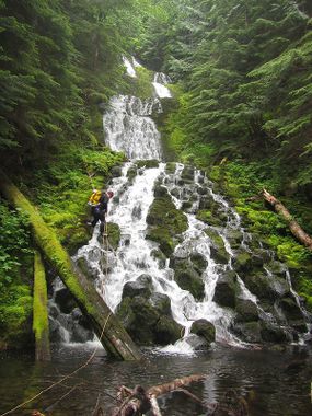
Wind Creek
| Rating: | |||||||||||||||||||||||||||||||
|---|---|---|---|---|---|---|---|---|---|---|---|---|---|---|---|---|---|---|---|---|---|---|---|---|---|---|---|---|---|---|---|
| | Raps:3-6, max ↨180ft
Red Tape:No permit required Shuttle:Required Vehicle:Passenger | ||||||||||||||||||||||||||||||
| Location: | |||||||||||||||||||||||||||||||
| Condition Reports: | 17 Jun 2018
"Some beautiful waterfalls - particularly the big one - but expect a fairly high pay-to-play. Lots of walking between falls. The lower end of the cre |
||||||||||||||||||||||||||||||
| Best season: | Apr-June
|
||||||||||||||||||||||||||||||
| Regions: | |||||||||||||||||||||||||||||||
Introduction[edit]
A pretty creek in the Mt. Hood vicinity. Wind Creek has great scenery, some nice waterfalls, and beautiful bedrock, but the pay-to-play is rather high. Expect much moss and long walks between rappels.
Approach[edit]
Drop a shuttle car at the defunct bridge across Camp Creek, then shuttle up to the Tom, Dick & Harry Trailhead (these days need to park at Snow Bowl). Follow the trail up onto the ridge. When you see the enormous rock cairn, this is a signal it's time to leave the trail. Thrash wherever is easiest down into the basin beyond. It's about 1mi of relatively easy bushwhacking down to reach Wind Creek. The USGS map labels this area as "Wind Creeek Basin" [sic].
Descent[edit]
- The first drop of any significance is located around 3800' elevation. It's an interesting low-angle falls composed of large mossy blocks of stone. Probably not worth the bother of rappelling, however. Bypass DCR.
- R1 & R2: Wind Creek Falls. Located at about 3500ft. The falls is composed of multiple tiers. We rappelled the first few running a 60m rope out to its entire length, then rigged a second pitch off a tree DCR to get down the last tier. The last tier might be downclimbable, but don't slip.
Continue downstream, passing occasional downclimbs.
- R3: 25ft.
We hiked along the south side for some time through largely open, easy forest, before dropping back into the creek. The lower section has long stretches of nice bedrock for walking, with the occasional downclimb along the way.
- R4: 30ft.
- R5: 15ft.
Exit[edit]
On nearing Camp Creek, bail out DCL and follow various user and game trails 0.25mi west to FR 2632 and the closed bridge (to vehicles) across Camp Creek.
Red tape[edit]
Might need a parking pass to park at SnowBowl these days.
Beta sites[edit]
Trip reports and media[edit]
Background[edit]
First descent by Keith Campbell and Kevin Clark in June 2018.
