Wolf Creek (Olympic Peninsula)
| Rating: | |||||||||||||||||||||||||||||||
|---|---|---|---|---|---|---|---|---|---|---|---|---|---|---|---|---|---|---|---|---|---|---|---|---|---|---|---|---|---|---|---|
| | Raps:3-7, max ↨115ft
Red Tape:No permit required Shuttle:None Vehicle:Passenger Rock type:Slate | ||||||||||||||||||||||||||||||
| Start: | |||||||||||||||||||||||||||||||
| Parking: | |||||||||||||||||||||||||||||||
| Condition Reports: | 17 Jul 2023
"No evidence of previous descent in canyon, nor can I find any info of the canyon online. So probable first descent. Ghosted canyon due to being unfami |
||||||||||||||||||||||||||||||
| Best season: | July
|
||||||||||||||||||||||||||||||
| Regions: | |||||||||||||||||||||||||||||||
Introduction[edit]
Fun midsize canyon filled with downclimb and rappels. Depending on how much you like biking, this is a worthwhile canyon. If hiking up, the pay-to-play ratio would lower quite a bit.
During the descent, my phone died, and could not record rappel lengths, so these are all by memory. The max rappel length is 105-115ft depending on anchor choice. This one I remember quite well.
Also I plan to add some more picture/flow analysis once I get back to my laptop (which might be near the end of August).
Note: the passage of bikes via the Bypass Trail along the Elwha is a privilege, please be courteous to other trail users. Also biking with heavy loads feels weird. The gravel road has been know to take some down, be careful.
Also, it’s a rare encounter but the NPS service has a truck on the washout side, so there are vehicles on the road to watch out for.
A pack animal can often be found, if you encounter any please dismount and get off the trail downslope of them. Take off your helmet/hat (hats/helmets can make you look scary to pack animals). Talk to them and their person as they pass.
Approach[edit]
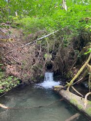
Start at the Madison fall trailhead. Bike up to till you reach the intersection of the watercourse and road. Stash bike Get into the watercourse
Descent[edit]
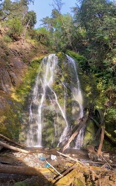
My phone died while on the first descent, so I was unable to record some of rappel length in the canyon. The longest drop is 105-115ft and is part of a two-stage drop. Next person to run it, please update this page with more precise and accurate rappel length, and remove this note
Photos from Northwest Waterfall Survey indicate that the major drop (as shown in cover photo) has a rooster tail in high flow, this may indicate hazardous conditions not yet encounter/written about.
All drops have a plethora of natural anchors; logs and logjams. I ended up to ghosting this canyon,(using retrievable slings) leaving no webbing in the canyon.
Logs are loose so use caution. The last 3 rappels had some loose rock in the watercourse their face, be careful.
I choose to enter the watercourse near where it crosses the road DCL. If you venture far up DCL you might avoid some mild bushwhacking but you gain elevation that you must descend again, choose your poison.
R1: Mild downclimb DCL, veer DCL. Downclimb first stage to sediment then second stage downclimb to log and crawl across to creek. If the logjam reshuffle it could become a rappel needing about ~30ft (hoz+vert).
R2: chill downclimb DCL out of water course on bedrock. If flows are high, rappelling could be needed here, if so ~20ft
R3: two-stage problem, has a pothole-like feature formed by massive boulder and logs. Right at the base of the first stage could become a strainer in moderate/high flow. Downclimb DCL using log and canyon wall. The log could become too slippery/unstable if so rap. Rap ~20
R4: part two of the two-stage drop. Flow splits into two paths. Downclimb DCL using logs and walls. Also could rap off the abundance of logs though they looked unstable and small so choose carefully ~25ft. Once at the bottom look behind the boulder for a treat.
R5: is part of a two-stage drop. I choose to do this in two pitches, you might be able to do this with just 1 pitch.
Theirs a lot of different options in and out of the watercourse. Theirs currently a convenient log that spans a right before the drop, it’s wedged in their tight but is small. Could easily be dislodged by high flow, check this anchor well. rappel needs ~40ft per long horizontal travel.
The untested idea for single rap; set a traverse line to access a large tree DCR above the flow of the first drop would also be an hanging belay. Estimated to be around 130-150ft.
R6: second pitch to rappel 5, you’ll reach a log spanning the canyon, it is cedar so it is kinda of bendy. 105-115 ft needed for this drop.
R7: 50ft of rope per long horizontal travel, it’s ~30ft drop. Used live cedar that twisted over the watercourse. Lots of loose twigs and branches on the tree that could result in a stuck rope, be careful.
Exit[edit]
Follow creek DCL till you see reach the sediment benches left by Lake Mill, climb up the slope of these. Then on top near the hillside, you’ll find the old Smokey trail. Take this trail to whiskey bend road, it’s in fairly good shape albeit with the downed trees. From the top take a left to head down the road back to where you stashed your bike. Bike out to Madison falls TH.
Red tape[edit]
Beta sites[edit]
Trip reports and media[edit]
Background[edit]
Documentation, scouting, and probable first descent by Thomas.
The drainage north, hurricane creek, is of the same geologic formation and looks like it has some promise.

