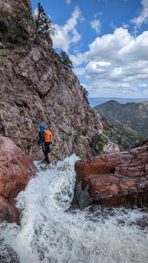
Y Bar Canyon
| Rating: | |||||||||||||||||||||||||||||||
|---|---|---|---|---|---|---|---|---|---|---|---|---|---|---|---|---|---|---|---|---|---|---|---|---|---|---|---|---|---|---|---|
| | Difficulty:3B IV (v3a2 IV) Raps:7+, max ↨160ft
Red Tape:No permit required Shuttle:Required 15min Vehicle:Passenger Rock type:Quartzite, Schist | ||||||||||||||||||||||||||||||
| Location: | |||||||||||||||||||||||||||||||
| Condition Reports: | 25 Mar 2023
"Rugged and beautiful. 3h approach, 3.5h descent, 4.5h exit. Replaced / rebuilt webbing and anchors at 6 out of 7 rappels. R7 pull was tough and it lik |
||||||||||||||||||||||||||||||
| Best season: | Spring
|
||||||||||||||||||||||||||||||
| Regions: | |||||||||||||||||||||||||||||||
Introduction[edit]
A good Mazatzal Mountains canyon with long and strenuous approach and exit hikes.
The hike begins at the Barnhardt trailhead which is accessed from SR87 near Rye, AZ. The trip can be completed by leaving a shuttle vehicle at the Deer Creek trailhead or by hiking back up to the Barnhardt trail via Shake Ridge. The ridge route may be slightly shorter, but it would add roughly 1600 elevation gain to the hike - pick your poison as they say. The parking for Deer Creek trailhead is signed and immediately across from the junction of SR188 on the west side of the road. The turnoff for Barnhardt trailhead is 3.4 miles north from Deer Creek trailhead on SR87 and is also signed and on the west side of the road. Drive 5 miles to the end of Barnhardt Road to reach the trailhead on what is typically a fairly well-maintained dirt road.
Approach[edit]
From the trailhead head south on Shake Tree Trail (also called Y Bar Basin Trail) for about 4 miles before leaving the trail to hike down the brushy slope into a shallow upper side drainage at a point of your choosing.
Note: The trail shown on maps descending to and crossing the Y Bar drainage is heavily overgrown and essentially non-existent as of March 2023.
Descent[edit]
R1: 60' off a rock pinch in the watercourse.
R2: 30' off a rock chock canyon right into a cold pool, immediately followed by R3. R2 and R3 could be combined for a rappel of about 80'.
R3: 25' from a tree canyon right.
R4: 50' (may be downclimbable in lower flow conditions) anchored from a tree in the watercourse.
R5: 70' off a small tree high canyon left into another cold pool (you can get off rappel on the left before committing to the short, but cold swim).
R6: 160' off a double rock chock canyon left down a beautiful cascading waterfall.
R7: 140' off a rock pinch, or high off tree for a smoother pull.
One more notable downclimb into another pool. Then begins the long exit hike (about six miles) which is long, strenuous, and most importantly long.
Exit[edit]
Continue hiking and downclimbing through and around the large boulders in the drainage - the further down canyon you get, the smaller the boulders become. After about 2 miles the canyon enters a lower section of narrows that can be either rappelled (you probably won't feel like putting your wet gear back on after miles of boulder hopping) or bypassed by climbing out of the canyon on the left and hiking along the rim of the canyon all the way to the junction of Shake Tree canyon which comes in from the left. Head down the nose of this confluence from the rim back down into Shake Tree Canyon and continue down for another .25 mile to reach the confluence with Deer Creek. Punch through the brush to find the Deer Creek Trail and follow it another 3 miles to the Deer Creek Trailhead.
Red tape[edit]
Beta sites[edit]
 Super Amazing Map : Y Bar Canyon
 HikeArizona.com : Y Bar Canyon
Trip reports and media[edit]
- https://www.facebook.com/pat.winstanley.7/media_set?set=a.1045172685541428.1073742062.100001461198708&type=3&pnref=story
- http://www.shadowcatadventures.com/y-bar-canyon-2/
