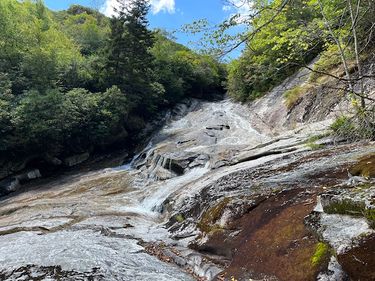
Yellowstone Prong
| Rating: | |||||||||||||||||||||||||||||||
|---|---|---|---|---|---|---|---|---|---|---|---|---|---|---|---|---|---|---|---|---|---|---|---|---|---|---|---|---|---|---|---|
| | Raps:3, max ↨200ft
Red Tape:No permit required Shuttle:Optional 2 mi Vehicle:Passenger | ||||||||||||||||||||||||||||||
| Start: | |||||||||||||||||||||||||||||||
| Parking: | |||||||||||||||||||||||||||||||
| Shuttle: | |||||||||||||||||||||||||||||||
| Condition Reports: | 19 Sep 2024
"Went after a lot of rain for both of our first times through the canyon. I definitely recommend going after a lot of rain as it would not have been n |
||||||||||||||||||||||||||||||
| Best season: | Anytime (avg for this region)
|
||||||||||||||||||||||||||||||
| Regions: | |||||||||||||||||||||||||||||||
Introduction[edit]
Creek stomp through Lower falls, rappel second falls (optional single pitch), continue down to Yellowstone falls (mandatory rappel 2 pitches), continue to skinny dip falls and exit to trail.).
Approach[edit]
Park at the Graveyard Fields Overlook Parking Lot. Go ahead and put on wetsuits here if you plan to wear one. Take the trail north down to Second Falls. Turn downstream the moment you cross the water and you will be right at the top of the first waterfall.
Descent[edit]
All three rappels have plenty of anchor choices to keep you in and out of the water, and they all have routes off in the bushes which allow you to climb down and bypass the rappels entirely. The beta below is what we did to stay as much IN the flow as possible.
R1 (Second Falls) - 150 ft off tree down canyon left.
R2 (Yellowstone Falls Upper Half) - 200 ft off tree down canyon right.
R3 (Yellowstone Falls Lower Half) - 100 ft off tree down canyon right.
The rest of the trip is boulder hopping until you reach skinny dip falls and exit to trailhead.
Exit[edit]
Option 1 (Recommended) - If you set up a shuttle, exit right from the river to the parkway from Skinny Dip Falls. The trail will end at Looking Glass Rock Overlook.
Option 2 - If you only have one car, you can exit the river left and get onto the MST which will take you in a loop back up to Second Falls.
Red tape[edit]
Beta sites[edit]
Bogley Outdoor Community - Tombstone Blues First Descent, Pisgah National Forest
Trip reports and media[edit]
Tombstone Blues First Descent, Pisgah National Forest - Bogley Outdoor Community Fridays on the Fly: Tenkanyoneering - Blue Ridge Outdoors
