Yucca Creek
| Rating: | |||||||||||||||||||||||||||||||
|---|---|---|---|---|---|---|---|---|---|---|---|---|---|---|---|---|---|---|---|---|---|---|---|---|---|---|---|---|---|---|---|
| | Raps:8-10, max ↨150ft
Red Tape:Access is Restricted Shuttle:Required 2 hours Vehicle:Passenger | ||||||||||||||||||||||||||||||
| Start: | |||||||||||||||||||||||||||||||
| Parking: | |||||||||||||||||||||||||||||||
| Shuttle: | |||||||||||||||||||||||||||||||
| Condition Reports: | 15 May 2021
"Used longer approach from Little Baldy Saddle as Crystal Cave Rd is closed. Approach added time and shuttle distance, tho upper canyon was cool and co |
||||||||||||||||||||||||||||||
| Best season: | Mar-Nov
|
||||||||||||||||||||||||||||||
| Regions: | |||||||||||||||||||||||||||||||
Introduction[edit]
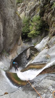
Yucca Creek heads down out of Sequoia National Park from Crystal Cave and cuts through a short but absolutely gorgeous technical section. The exit is unfortunately long and tedious.
Approach[edit]
From Little Baldy Saddle, hike southwest to the top of the hill. Drop down the other side into a small drainage. Follow this small drainage down til it starts to become steep, then cut left, staying on the west side of the ridgeline where it's not too brushy, eventually cutting right into the drainage. Another creek will join from the right, 500ft above the first technical section.
Alternative: From the Crystal Cave parking, hike down to Crystal Cave, pass the spider web gate and head down the path from there. It eventually gets narrow, cuts down to Yucca Creek and disappears. Just head down from here. It's about an hour of climbing over logs and bushwhacking to the first rappel.
Descent[edit]
The upper technical section starts 500ft below the confluence of two forks, with scenic waterfall rappels (up to 150ft), that can be done dry to either side of the falls, saving you from having to put your wetsuit on too soon. After 4-5 rappels, it goes back to creek walking. Eventually the creek goes dry (I think water gets pulled off into Crystal Cave). Below here is a sizeable dryfall, down-climbable on the left. Soon after, flow rejoins as Cascade Creek enters from the left.
Just past Cove Creek, there's a 90ft sliding rappel (longest in this section). Just after is a shorter dropped anchored from way back on a tree. You'll soon enter a very scenic gorge with short slides between potholes. Next significant drop is a potenital jump or slide, followed by a rappel (looks like a great slide, but its shallow. Good spot for cairn anchor in a crack above it). Last is a drop beside a tree (big rocks in the pool, probably don't jump) that can be dwonclimbed or rappelled. This section goes by too fast, but there are not many slots like this in the Sierra.
Exit[edit]
So yeah, basically downstream. You might think it would be a good idea to hike on the sides, and I'm sure you'll try it, but neck high poison oak will chase you back every time. 4 or 5 miles of bushwhacking down a slippery creek til you get to the last mile or 2 of trail. If you stay in the water, there is no poison oak, just lots of spice bush, which smells nice, and is fairly soft. So that's nice I guess? It might take you anywhere between 3 and 9 hours to get down this.
The last 2 miles has a reasonable trail (although the 1st mile of it has pretty serious poison oak, so if you hate PO more than walking in the creek, wait a little longer). Just over 3 miles, reach a pair of big granite slabs separated by a short drop and a pool. Find the trail down on the right at the bottom of this one. Go into the forest for a moment, then climb slabs up to the right to stay on the trail when things open up again.
- This trail is on 1945 topo maps, going from the lower trailhead up Yucca Creek, then cutting up a ridge (.75mi down from the technical gorge) to Colony Peak. However the trail is old, eroded, overgrown, and gone in many places. It's possible that you could find the trail and hike it up to Crystal Cave Road, though the night-time closure of the road might make doing so risky. It's also possible that you might find more useful pieces of it upstream of the last 2 miles, though when I tried this, I found the trail to be in horrible shape, and the poison oak to be even worse.
Red tape[edit]
Crystal Cave Rd is only opened for limited hours for access for cave tours. The Little Baldy Saddle access is recommended.
