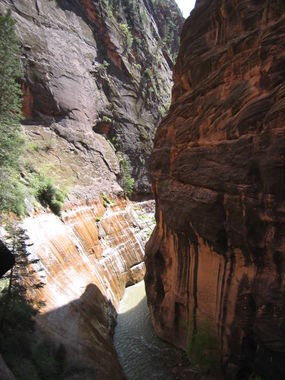
Zion Narrows (Lower)
Jump to navigation
Jump to search
Also known as: Virgin River Narrows; Zion Canyon.
| Rating: | |||||||||||||||||||||||||||||||
|---|---|---|---|---|---|---|---|---|---|---|---|---|---|---|---|---|---|---|---|---|---|---|---|---|---|---|---|---|---|---|---|
| | Difficulty:2B II (v1a2 II) Raps:
Red Tape: Shuttle: | ||||||||||||||||||||||||||||||
| Location: | |||||||||||||||||||||||||||||||
| Condition Reports: | |||||||||||||||||||||||||||||||
| Best season: | Summer; Fall
|
||||||||||||||||||||||||||||||
| Regions: | |||||||||||||||||||||||||||||||
Introduction[edit]
The Zion Narrows can be visited as a in-and-back hike from the north end of Zion National park, the area called Temple of Sinawa. No permit required for this option. Most people do not venture beyond the confluence with Orderville.
They can also be explored on the way out of some other technical canyon that ends in the Narrows, like Englestead, Mystery or Imlay.
They can also be explored in its entirety in a 2 day one-way backpacking trip from top to bottom to avoid hiking against the currents. This option will require a permit. Some hikers opt to do it in a very long day (12h+). A permit is required for either a one day or two day trip from the top down.
Approach[edit]
Descent[edit]
Exit[edit]
Red tape[edit]
Beta sites[edit]
 Chris Brennen's Adventure Hikes (Southwest) : Zion Narrows
 RoadTripRyan.com : Zion Narrows From the Bottom
 Climb-Utah.com : Zion Narrows
 HikeArizona.com : Zion Narrows
 Super Amazing Map : Zion Narrows (lower)
 AmericanSouthwest.net : Zion Canyon
 ToddsHikingGuide.com : Zion Narrows
 SummitPost.org : Virgin River Narrows
Trip reports and media[edit]
 Candition.com : The Narrows
