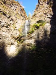
Able Creek
| Rating: | |||||||||||||||||||||||||||||||
|---|---|---|---|---|---|---|---|---|---|---|---|---|---|---|---|---|---|---|---|---|---|---|---|---|---|---|---|---|---|---|---|
| | Raps:5-6, max ↨80ft
Red Tape:Permit required Shuttle:None Vehicle:Passenger | ||||||||||||||||||||||||||||||
| Location: | |||||||||||||||||||||||||||||||
| Condition Reports: | 26 Mar 2022
"Able is truly a gem. Don’t get hung up on the 5 miles. Just bring mountain bikes and it makes it much more easier. The long creek walk out? Don’t |
||||||||||||||||||||||||||||||
| Best season: | april-Sept
|
||||||||||||||||||||||||||||||
| Regions: | |||||||||||||||||||||||||||||||
Introduction[edit]
A beautiful creek with a short technical section. Expect a lot of hiking on the way in and out, making this one a high pay-to-play. This area is frequented by hunters in season, so wear bright colors.
- bring bikes for a quicker approach
Approach[edit]
Directions[edit]
From the small community of Northwoods, WA along the Lewis River, locate the Eagle Cliff store & campground. Across the street take the No 10 Rd (not signed) downwards for 0.4mi to a gate and turnaround. Park here, but don't block the gate. This is the same trailhead for Northwoods Creek. In 2020, Rayonier Tree Farm purchased the land and a permit to access the land is needed.
Hike In[edit]
Follow a maze-like series of logging roads up along the east side of the creek. Go past a minor tributary at the top and, after a small washout, thrash straight down to drop into the creek. Expect to take ~1.5hrs.
Descent[edit]
The full distance in the creek is about 2mi. Expect significant stretches of walking between rappels.
- R1: 50ft.
- R2: 20ft.
- R3: 30ft.
Able Creek Falls (R3-R6). This falls is deep in a narrows and has three rapid-fire rappels. Entering this area in high water could be extremely dangerous; there is no escape.
- R4: 30ft.
- R5: 45ft and mandatory swim. *Alternatively, there’s a bolt DCR, more sporty and no swim.
- R6: 80ft + extra rope per the anchor being set back from the top. Alternatively, bolt DCL near the the lip.
Look for a natural arch high in the cliffs downstream of the main falls. Continue downstream perhaps another hour to the bridge. Some nice sections of bedrock, but expect lots of rock hopping. Stay in the creek as much as possible to avoid impact to the fragile riparian environment.
Exit[edit]
Upon reaching the bridge, turn right/east and hike back out along the road. The road takes about +30min.
Alternatively, hike back up to the forest road and walk it out or use a bike to cruise down in 35 minutes.
Red tape[edit]
Free non-hunting recreational permit from Rayonier Hunting & Recreation is required. "Pope Swift South Non-Hunting Individual" is what you need.


