Barranco de Huaxtla
| Rating: | |||||||||||||||||||||||||||||||
|---|---|---|---|---|---|---|---|---|---|---|---|---|---|---|---|---|---|---|---|---|---|---|---|---|---|---|---|---|---|---|---|
|
| |||||||||||||||||||||||||||||||
| | Difficulty:3B II (v4a4 III) Raps:4 + 4 jumps, max ↨225ft
Red Tape:No permit required Shuttle:Required 45 minutes Vehicle:Passenger Rock type:Rhyolite | ||||||||||||||||||||||||||||||
| Location: | |||||||||||||||||||||||||||||||
| Condition Reports: | 22 Mar 2021
"The water is blue but not seethrough. Though they are deep enough to jump the drops. Waterquality might not be so good. The canyon is short but scenic |
||||||||||||||||||||||||||||||
| Best season: | Dec - May
|
||||||||||||||||||||||||||||||
| Regions: | |||||||||||||||||||||||||||||||

Introduction
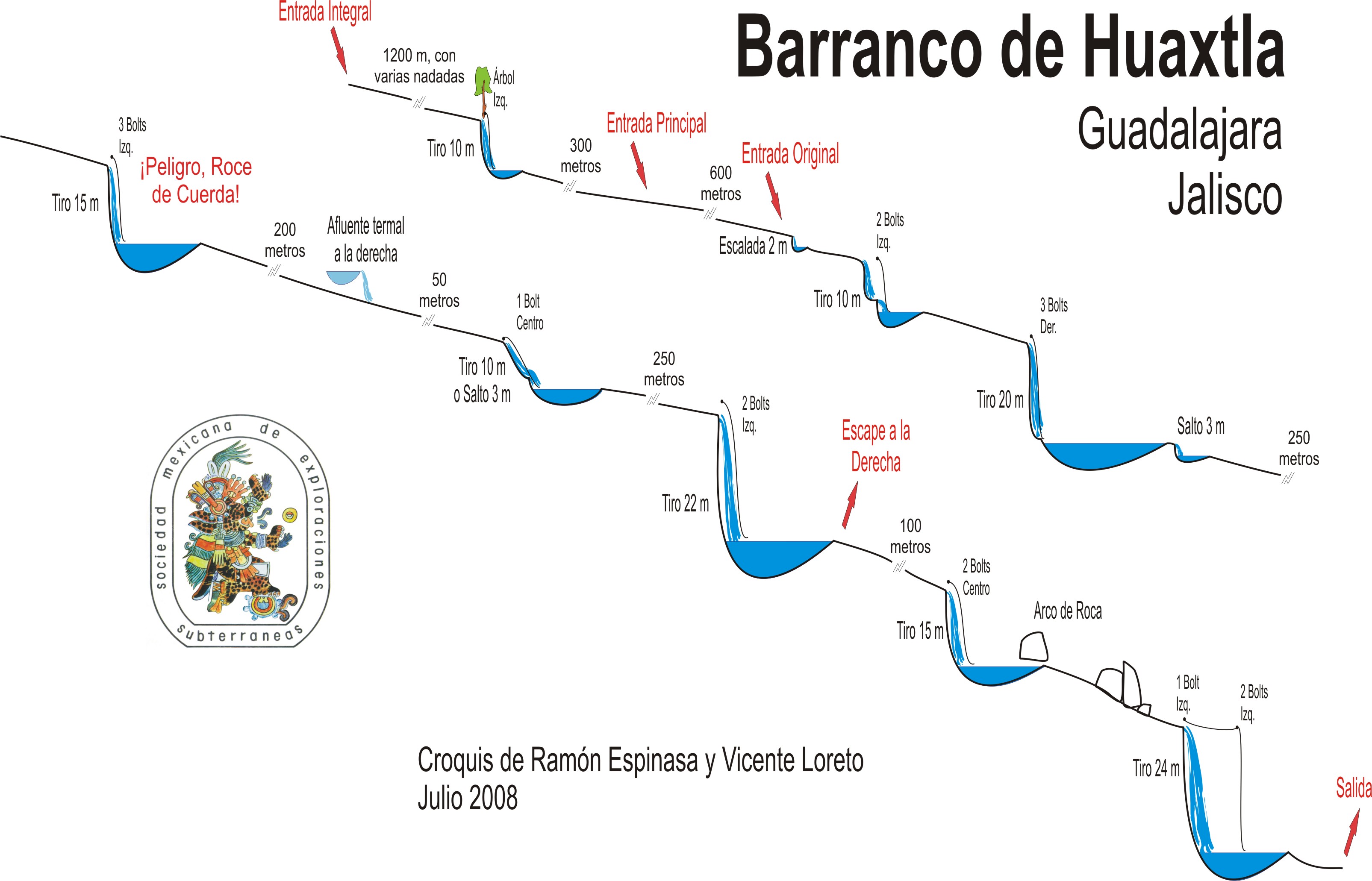
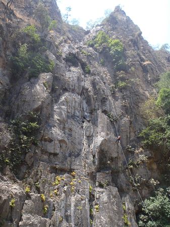
This canyon is located about 45 minutes NW of Guadalajara and was the first technical canyon done in Jalisco in the mid 1990's. It is developed in very hard rhyolite with very tall and narrow walls (which themselves are well known for hard rock climbs) creating a very spectacular setting. Unfortunately a garbage dump has been built in the headwaters of this stream, so it is not recommended to visit between June and Nov. when the rainy season can wash contamination from the garbage dump down the stream. Fortunately there are a number of springs midway down the canyon, that give fresh water for the dry season.
Approach
The standard approach now that the canyon can only be done in the dry season is to take the road that goes to the village of Huaxtla, and stop just before the cow grate at the top of the hill and park on the left. From the car pull out, walk back downhill, to the previous arroyo, and follow that 360 feet / 100m to the top of the first rappel. Note: this access comes in after R4, and arrives right at R5 (which everybody now jumps).
El acceso más alto se encuentra en el kilómetro 18 de la carretera de Guadalajara a San Cristobal de la Barranca, punto en que se cruza el río por un puente. Sin embargo el acceso más recomendable se encuentra en el kilómetro 20, en el Rancho El Robledal. Tras la construcción de la entrada se ve una pequeña presa, que hay que rodear para bajar al barranco siguiendo el desague de la presa.
Descent
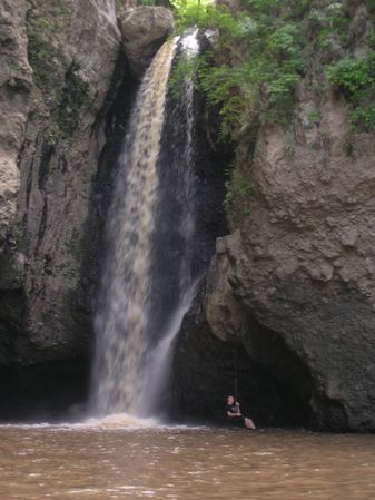
The entrance rappel is 352 feet / 110m, with a re-belay ledge at the 130 foot / 40m mark. From there it is a downclimb over boulders to reach the main stream and right into the 1st jump at R5 (of 10 to 21 feet). Follow the obvious water course downstream passing R6 (which can be jumped by those brave people willing to jump 70 feet / 22m), R7, which is usually jumped but can be climbed around on the left, and then the final R8 - known as the Cascada de San Lorenzo (this can be rappelled on either the left or right depending on water levels, but should Not be jumped).
La primera parte es relatívamente engorgada, y el recorrido se hace muy deportivo, con numerosos destrepes, nadadas y cortos saltos. Los primeros rápeles son muy estrechos en su cabecera, pero posteriormente el barranco se abre bastante y únicamente se estrecha en las cascadas. Muy escénico.
Exit
From the last pool, climb over boulders for some 60m until finding an old aquaduct, follow the old aquaduct about 1km until passing uphill through a mango orchard, and gaining a small road that leads into the village of San Lorenzo, where your car should be parked.
Poco después de la última cascada se encuentra un canal y vereda a la izquierda que hay que seguir hacia el poblado de San Lorenzo, donde se habrá dejado un coche.
Red tape
There has been access issues with the village of Huaxtla, so it is preferable to get dropped off at the Approach park pull out, and then leave the car down in San Lorenzo.
Beta sites
 JaliscoVertical.Weebly.com : HUAXTLA
- Barranquismo.net : Huaxtla
- Cañonismo.com : Huaxtla
Trip reports and media
Access Rappel of 110m
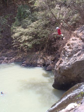
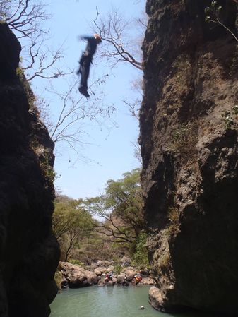
Jumping R5
R6 in summer high water flow - not recommended these days with the new garbage dump upstream. Some people have jumped from the rock atop the cascade.
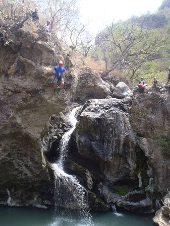
Jumping R6 from midway up
Jumping from the high side of R7
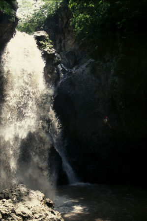
Rappelling the dry side of R8 in summer high water conditions


Background
This canyon was pioneered by Vicente Loreto in the early 1990's, hand drilling bolt holes, which typically took 2 hours each in the hard rhyolite rock. Combined with breaking the drill bits, it took a number of trips to rig all the cascades. Some glue-in bolts were added in the later 2000's by parties unknown, and the last cascade - R8 - San Lorenzo had bolts added to the wet side in May 2014 by Chris Lloyd.
 Vicente Loreto rappeling R3 in 1995
Marcelo Villavicencio, del Club de Exploraciones de México A.C. realizó el primer descenso de las últimas dos cascadas. La exploración y armado de la parte alta del cañón se realizó por iniciativa de Vicente Loreto, apoyado por Alejandro González, Bernardo Alcantar y Alexandra Taylor, de 1989 a 1992. La instalación fue particularmente dificil por la dureza de la roca, y cada spit les tomó de 1 a 2 horas, y rompieron dos martillos. Se desconoce quien instaló los anclajes químicos.