Bear Creek (Sierra National Forest)
| Rating: | |||||||||||||||||||||||||||||||
|---|---|---|---|---|---|---|---|---|---|---|---|---|---|---|---|---|---|---|---|---|---|---|---|---|---|---|---|---|---|---|---|
| | Raps:6?, max ↨200ft
Red Tape:No permit required Shuttle:Required 15 min Vehicle:Passenger | ||||||||||||||||||||||||||||||
| Start: | |||||||||||||||||||||||||||||||
| Parking: | |||||||||||||||||||||||||||||||
| Condition Reports: | 16 Jul 2022
"Went through and replaced all the webbing, and added bolts to make the R5 hallway more manageable. The flow was pretty low, but still enough to make s |
||||||||||||||||||||||||||||||
| Best season: | June-Sept
|
||||||||||||||||||||||||||||||
| Regions: | |||||||||||||||||||||||||||||||
Introduction[edit]
With two narrow granite hallways taking 100% of the flow, Bear Creek should not be underestimated. Potholes, downclimbs, and a long slabby rappel round out this canyon. Natural anchors can be found/made with care, but some rappels would be better if bolted (as of July 2022, all sketchy rappels have been bolted).
Waterflow can be estimated from the road, or more accurately by following the use trail from the road up to the final rappel.
Approach[edit]
This canyon is on the way to McKinley Grove, just off Dinkey Creek Road fifteen miles past Shaver Lake. Park at the pullout by the bridge. Shuttle back up McKinley Grove Road, turning right at the sign for Swamp Lake up forest road 10S13 and park in the clearing (37.0516, -119.1151). The road is marked as an OHV route but is partially paved and passenger cars should have no trouble. Continue down OHV route 10S13G by foot for a little under a mile. At the “No vehicles” sign/end of route, turn off the trail and downhill 250 feet to the creek.
Descent[edit]
Cross the creek and walk DCL along boulders until the canyon opens up and begins to drop. Suit up here. Fun and occasionally deep potholes greet you, getting gradually steeper and descending into a slot, which drops off 15’ for R2. This is the first granite hallway, which is bypassable if needed DCR. In lower flow it may be possible to downclimb in the watercourse; we (first descent) fiddlesticked the second large tree DCR to drop 50’ into the slot before R2 15’ from a large flake DCL. Choosing a tree further downcanyon would allow combining these rappels and staying out mostly of the flow. Stem/downclimb the rest of the hallway.
The creek widens and some routefinding around boulders is necessary. Continue downcanyon until the obvious drop. R3’s anchor lies within/around the large boulders DCL. Rappel (125’) as much in the flow as desired. In very high flow, DCR provides a dry option.
As the canyon bends to the right, downclimb DCL, jump (shallow!) 5ish ft center, or rappel from a log DCR. Continue downcanyon, downclimbing as necessary, until the flow funnels into a second slot. The crack can be downclimbed until a boulder choke, at which a bolt provides a location for a handline. It may also be possible to bypass this first drop entirely by entering the slot by downclimbing DCL. The next several small drops are partner assist downclimbs, generally to the left.
R5 is a short drop from a bolt DCR, after which the remainder of the hallway can be downclimbed.
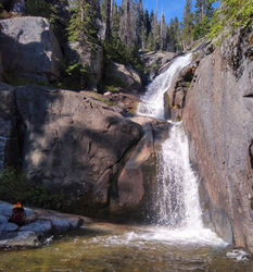
R6 is the top of the three-stage waterfall visible from the road. There is a tree DCR that can be fiddlesticked with 200’ of rope to descend the first two stages. This rappel (200’) is stairsteppy, the most direct line is in the flow, but diverging to avoid it is straightforward. If the flow is not too high the entire drop can be downclimbed.
R7 is anchored off a bolt on the wall DCL, about 40'. At the bottom there are nice slabs to dewetsuit and dry gear.
Exit[edit]
Take the established use trail DCR back to the road.
Red tape[edit]
Beta sites[edit]
Trip reports and media[edit]
June 2020 trip report and photos by Quinn Shemet
Background[edit]
First known descent June 2020 by Carly, Quinn, Evan, and Gavin

