Big Creek (Olympic Peninsula)
| Rating: | |||||||||||||||||||||||||||||||
|---|---|---|---|---|---|---|---|---|---|---|---|---|---|---|---|---|---|---|---|---|---|---|---|---|---|---|---|---|---|---|---|
| | Raps:0-1, max ↨20ft
Red Tape:No permit required Shuttle:Optional 2 min Vehicle:Passenger | ||||||||||||||||||||||||||||||
| Location: | |||||||||||||||||||||||||||||||
| Condition Reports: | 18 Jun 2023
"The log jam has shifted a bit and the rappel is now optional. There is a rock shelf DCR you can step down to and down climb into the creek, or a deep |
||||||||||||||||||||||||||||||
| Best season: | Jul-Sept
|
||||||||||||||||||||||||||||||
| Regions: | |||||||||||||||||||||||||||||||
Introduction[edit]
A nice short narrows on Big Creek (Wynoochee Valley) located just above FR 22. While not a major destination in its own right, it's worth a visit if you're in the area and have a little time to spare. Can be run an hour (or less if you have a shuttle).
- A wetsuit is recommended. Have your flotation dialed.
- The checkpoint is Big Creek from the bridge. Or just above the narrows.
- The Big Creek Narrows is easily combined with other destinations in the Wynoochee Valley. It's possible to visit 2-3 of them in a single day.
- While the original beta described this as a non-technical descent, a large logjam requiring a rappel has appeared near the top of the narrows. For the first descent in a given year, it may be wise to bring a short rope and harness. Logs washed downstream can get jammed in constrictions. More debris fills in behind them to create a natural dam. Sometimes, they can get quite large. Technical gear provides options should you need them.
Approach[edit]
Follow FR 22 to the bridge where it crosses Big Creek. This is a good place to check the flow. The creek is not impressive from the bridge. Leave a car here and shuttle (or hike) east 0.2mi, then left on FR 2294. Follow for about 0.5mi when you can see the creek down through the trees on the left. Park along the side of the road. There was a wide shoulder as of 2020 with plenty of room for parking. Suit up on at the road and bushwhack down wherever is easiest and drop into Big Creek.
- There are a couple of campsites right at the bridge over Big Creek.
- The original beta described following FR 2294 to the next bridge over Big Creek and descending from there. This will add +0.7mi of river walking with no additional narrows. Not recommended.
Descent[edit]
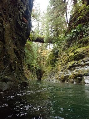
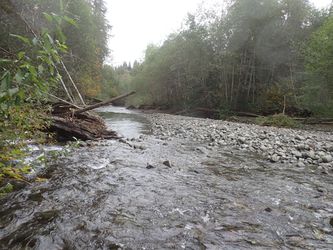
Head downstream about 5min. At first it is not very impressive. The creek then abruptly swings left and the scenery changes dramatically. Enter the narrows. In several places fallen logs span the narrows overhead dripping with ferns and other epiphytes. Be aware the current can be strong in places.
- R1: 10ft. As of 2020 a giant logjam has appeared inside the narrows. Bring a short rope to rappel down to the bottom. Might be possible to downclimb and pass underneath the logjam, but might not be recommended if the flow is high.
Pass through a beautiful narrows below the logjam. Sadly, the narrows is short and sweet. The creek passes through an interesting area of bedrock channels, then opens out again. An old water gauge station DCL is a sign you're getting close to the bridge.
Exit[edit]
You can exit DCL up to the campsite, or, if occupied, continue to the bridge and exit DCL up to the road.
Red tape[edit]
None.
Beta sites[edit]
 CanyoneeringNorthwest.com (archive.org) : Big Creek Narrows

