Big Granite Canyon (Upper)
| Rating: | |||||||||||||||||||||||||||||||
|---|---|---|---|---|---|---|---|---|---|---|---|---|---|---|---|---|---|---|---|---|---|---|---|---|---|---|---|---|---|---|---|
| | Raps:1-5, max ↨215ft
Red Tape:No permit required Shuttle:None Vehicle:Passenger | ||||||||||||||||||||||||||||||
| Start: | |||||||||||||||||||||||||||||||
| Parking: | |||||||||||||||||||||||||||||||
| Condition Reports: | 6 Sep 2025
"UBG exploration, with a run of the lower section on the way out.. Upper section is fine. As mentioned, worse rock and less water because its above |
||||||||||||||||||||||||||||||
| Best season: | Jun-Aug
|
||||||||||||||||||||||||||||||
| Regions: | |||||||||||||||||||||||||||||||
Introduction[edit]
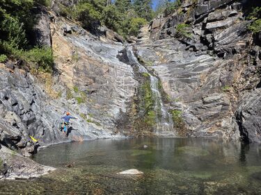
Upper Big Granite is a remote, short, pretty section of creek off of the North Fork of the American River. In contrast to Big Granite Canyon (Lower), the rock is notably lower-quality. The flow is also substantially lower, as the upper section is above the confluence with Little Granite Creek. That said, it is a pleasant section of gorge, with at least one or two very cool drops and a cute little jump.
With its remote access and lack of an obvious exit before the intersection with the Big Granite Trail, Upper Big Granite has a rather absurd pay-to-play ratio if done by itself. Combined with the (much better) lower section, Big Granite Canyon can serve as a long hard day hike or chill overnight backpacking trip with a little bit of canyon to spice it up. If you’re in the area and game for an overnight, you’re likely better served by combining Big Valley Canyon and Lower Big Granite, but it’s possible the full Big Granite descent could be a viable backup option if Big Valley flows are too high.
Approach[edit]
The approach point is similar to that for Lower Big Valley. Follow the roads to Sugar Pine Point from the Yuba Gap exit. The road to the yellow gate near (39.25190, -120.53720) is, as of September 2025, relatively friendly for passenger cars. There’s a good flat camp spot off of the road to the left shortly before the gate. Leave a car at the gate (or camp spot) and continue down the road on foot.
Follow the road/trail towards Cherry Point. You’ll pass the Big Granite Trail to your right; that’ll be your exit. We went all the way to Cherry Point proper, then descended the 1500 ft to the creek in and around the gully near 39.25913, -120.51079, joining with the creek at 39.25407, -120.50231. This slope is quite steep, composed of loose shale, and covered with thick live oak and manzanita. From map, satellite, and what we observed while descending, it looks much more pleasant to continue along the ridge upstream to the northeast until the terrain gets lower-angle and less brushy, maybe somewhere near 39.27258, -120.50568.
Descent[edit]
Big Granite Creek steepens as it approaches the ridge down from Cherry Point. First is a large blocky falls, which might be a pleasant rappel into a pool DCL, but is also easily downclimbable. More downclimbs follow, then the canyon drops before the confluence with a small creek on the left.
- R1: Fiddlestick from tree center, around 215’ all the way to the canyon floor. It may be better to stop at the small ledge around 200’ from the tree. The center of this ledge hosts a rope-eating flake, and the downclimb off of it DCL is easier than it looks. The whole rappel can also likely be bypassed.
- R2: Fiddlestick from horn/flake DCR, 65’. Ample opportunity for knot chocks DCL. Likely bypassable far DCR.
- R3: Fiddlestick from big oak tree DCL, 150’. This is the most mandatory rappel. It seems likely possible to bypass DCR, but would be steep, sketchy, and unpleasant.
- R4: Probably 40’ish? from fallen log, or downclimb to jump DCL. Slightly technical jump; the depth in the pool varies substantially.
Exit[edit]
Creekwalk 1.75 mi until the creek crosses the Big Granite Trail. Drop your packs (or continue to the river to set up camp) and go do the lower section! Then take the trail back to your car.
