Booth Creek
| Rating: | |||||||||||||||||||||||||||||||
|---|---|---|---|---|---|---|---|---|---|---|---|---|---|---|---|---|---|---|---|---|---|---|---|---|---|---|---|---|---|---|---|
| | Raps:2-3, max ↨130ft
Red Tape:No permit required Shuttle:None Vehicle:Passenger | ||||||||||||||||||||||||||||||
| Location: | |||||||||||||||||||||||||||||||
| Condition Reports: | |||||||||||||||||||||||||||||||
| Best season: | Jul-Sep
|
||||||||||||||||||||||||||||||
| Regions: | |||||||||||||||||||||||||||||||
Introduction[edit]
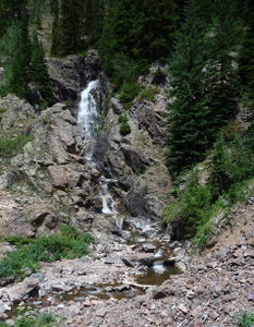
Booth Creek is perhaps the best canyon descent that can be done as a day trip from the Denver area. It has a taste of what a real canyon has to offer: a big waterfall into a pool and steep walls that almost form a narrows section. Booth Creek is a cold mountain canyon, requiring a full wetsuit.
However, Booth is relatively short. One perspective: "With only two rappels, one of which is unremarkable and the other is a decent, semi-long rap in an aerated and widely spread cascade suitable for beginners, this creek is below average by any measure for Colorado. There is no commitment zone as the short area between the two rappels is escapable. Think of it as a hiking day with 2 bonus rappels. The first rappel ends in a deep pool and there is a ledge 20 feet above the surface, a potential jumping perch."
Stream Gauge for Booth Creek: http://waterdata.usgs.gov/co/nwis/uv/?site_no=09066200&agency_cd=USGS
There is usually 4 or 5 more cfs running than what the gauge says. As an approximate suggestion, intermediate canyoneers can descend up to 10cfs. Descending at higher than 15cfs is not advised. The current is swift and the drops are dangerous. Descend with proper training in wet canyon techniques.
Approach[edit]
Driving: There is no parking at the Booth Lake trailhead or any surrounding Neighborhood. Visitors must take the free shuttle from inside Vail. Take I-70 to the Vail Town Center exit (Exit 176). Park for free (day parking/$25 overnight/no longer that 14 days) at the Vail Village parking garage and take the free bus outside the transportation center to East Vail. The bus departs approximately every 30 minutes. Get off at the Booth Falls bus stop and head up 1/4 mile up the road until you reach the Booth Lake trailhead.
Hiking: From the trailhead, hike 2.2 miles north on the Booth Creek Trail through a spectacular aspen forest. Notice the fault where the limestone ends and meets the Precambrian granite of the Eagle's Nest Wilderness area. The forest opens into a willow-lined valley near the first glimpse of one of the falls. Continue steeply up the trail to various overlooks at the top of Booth Creek Falls. This is a great spot to scout the water level. The trail passes the top of the falls and a sneak route entrance could be made here.
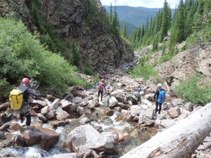
To gain one additional short rappel and a quarter mile of stream walking in The Upper Gorge, continue up the trail beyond the top of Booth Falls. In another quarter mile, the valley opens with sides of talus slopes as Booth Creek comes into view again below to the left. Scramble down the talus to the level of the creek, don your wetsuit and technical gear, and head down canyon.
Descent[edit]
The Upper Gorge makes a good warm up and includes several small drops can be downclimbed in lower water flow.
R1: 25' from a tree on Canyon Right
The Upper Gorge ends at the top of Booth Creek Falls by the trail. Exit here if needed. Enter here to skip the Upper Gorge and skip the additional combined half mile approach and stream walking.
R2: 130' from a boulder in Canyon Center. The pool at the bottom is a deep swim. Set the rope length, as a hydraulic could be dangerous with extra rope. Be careful with the pull as ropes have been stuck here before. This rope length had previously been listed as a shorter estimate and has been increased to 130' after a descent where it created a dangerous situation with the rope coming up short.
Downclimb in the gorge until the next drop
R3: 110' two-tier from a tree on Canyon Right. Beware a sharp edge the rope runs over.
R3 ends in a pretty amphitheater. Downclimb over a logjam and several short drops to the exit.
Exit[edit]
All too soon the gorge ends and willows take over. Follow faint trails on the east side of the creek back to the main trail. Send someone up the trail to retrieve the webbing and you're done!
Red tape[edit]
This canyon is in the Eagles Nest Wilderness. Please follow leave-no-trace techniques and leave the electric drill at home.
The top of Booth Falls (R2) is a popular hiker destination, so send someone to retrieve the webbing anchor after the descent!


