Box Canyon (British Columbia)
| Rating: | |||||||||||||||||||||||||||||||
|---|---|---|---|---|---|---|---|---|---|---|---|---|---|---|---|---|---|---|---|---|---|---|---|---|---|---|---|---|---|---|---|
|
| |||||||||||||||||||||||||||||||
| | Raps:9, max ↨82ft
Red Tape: Shuttle: Vehicle:Passenger Watercraft:Yes Rock type:Granite and Basalt | ||||||||||||||||||||||||||||||
| Location: | |||||||||||||||||||||||||||||||
| Condition Reports: | 29 Jun 2026
"Amazing day in Box! Some logjams have moved in the middle section. This gets rid of one of the raps as the anchor is now ~15 feet above the canyon. It |
||||||||||||||||||||||||||||||
| Best season: | Jun-Oct
|
||||||||||||||||||||||||||||||
| Regions: | |||||||||||||||||||||||||||||||
_Banner.jpg)
-20141119045431_pic.jpg)
-20141119045528_pic.jpg)
-20150722011351_pic.jpg)
-20210812181400_pic.jpg)
-20141119045717_pic.jpg)
-20141119045829_pic.jpg)
Introduction
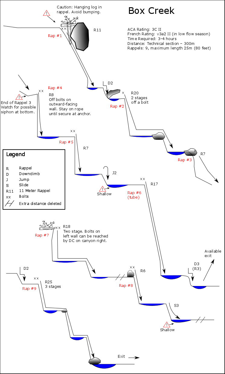
Crystal clear water, polished granite and mossy green landscapes make of Box Canyon one of the best canyons of British Columbia. This canyon is adjacent to Monmouth Canyon but much shorter. Box is known for changing dramatically year to year; more than most canyons in the region. As a result, the beta as written is almost always partially outdated. Due to changing floors, accessible bolts one year become far out of reach the next. The first run or two of the season should be prepared to fix/install anchors. Subsequent teams should look around for anchors that make sense. Relying solely on the beta will likely mislead you. (Note that the topo is also outdated)
Approach
River Crossing
See Crossing The Squamish River
Box Canyon Hike
The hike in is marked with pink flagging tag and follows a trail for the first half of the approach.
Mon-Box Approach
Some teams will run Upper Monmouth Creek, then cut over through open forest to Box from the bottom of Keyhole Falls. This makes for a pleasant longer day of canyoning.
Descent
_Box-2016.png)
The hanging log pictured in the above diagram is now gone. The log jam at the first rappel is growing, and there is a considerable increase in gravel and debris descending the watercourse as of Sept. 2018..
Update August 2020: Rappel 1 route under the hanging rock has filled completely. R1 is now technically a three-stage rappel, maybe better as a two-stage rappel with a break at first pool.
Update Sept 2023: Can confirm that R1 is a THREE STAGE. Also can confirm that, ideally, it should be bolted after the first stage. But it seemed to pull ok. Didn't measure it out in the commotion to find an anchor, but roughly 80-90' total. Immediately after this is another drop that seemed to have no anchor in place. We double stranded off of a suspended log DCL in the flow. About 18', plus a short second stage that can be rapped on the same rope or downclimbed. There are also currently logs to anchor off of DCR. Immediately after is a chute that can be downclimbed to the edge with bolts DCR. Belay your first or less experienced as necessary to the edge.
The canyon is now bolted. Just keep in mind that there are a couple of two and three stage rappels, reusing a same anchor to rappel two or three consecutive waterfalls (Rappels 1, 2, 7, and 9). You will lose sight of the people on rappel, so in high water you may want to station canyoneers along the way to keep an eye on the least experienced or even better, find some locals that might be willing to show you the way.
Note: The second rappel anchor location has changed! Do not anchor off of the two obvious bolts on top of the boulder to canyon right of the water course. They have been seriously compromised by flow and debris from the last couple of winters. A new bolt has been installed (2016) off to the left. Move canyon left, around the big rock and find one big, burly rap bolt facing down canyon. Rappel down, across the log and to the lip of the vertical pour off, where you'll find another anchor facing out, just around the corner (rappel 4).
Note S3 is too shallow to slide (2020) "Rap 8" is now two-stage.
Note D3 may not be doable, currently requires rap off tree canyon left. (2020)
Note Rap 7 can now be done as two separate raps (2020)
British Columbia folks are very friendly, if you post on the facebook group 'Vancouver Canyoning' you will find many locals that will be happy to come along and show you their finest canyons.
Exit
Upon exiting the canyon, hike out the way you came. Once you reach the river, it is likely that you will find that the tide has changed and the current may be more difficult. It is possible to paddle upstream on the side bank and then paddle downstream to the canoe drop-in point or paddle directly across the Squamish river to the canoe drop-in point or slightly past the drop-in point and then hike back to the car. The attached map displays all the possibilities, but current and tide may allow you fewer options.
Red tape
The canyon is located on Crown land, however it is part of an agreement with the Squamish Nation - the land is part of a designated culturally significant area. Travel through the canyon by private parties is permitted, but not by commercially guided groups. Canyoneers are requested to be respectful of the land, and minimize impacts.
Beta sites
- BC Canyoneers
 CanyonCollective.com : Box Creek
Trip reports and media
Background
Details of the first bolting (10th June 2014): https://web.archive.org/web/20180820092708/http://bccanyoneers.com/2014/06/14/bolting-box-canyon/