Break Hollow
| Rating: | |||||||||||||||||||||||||||||||
|---|---|---|---|---|---|---|---|---|---|---|---|---|---|---|---|---|---|---|---|---|---|---|---|---|---|---|---|---|---|---|---|
| | Difficulty:2A II R (v1a1 II) Raps:0
Red Tape:No permit required Shuttle:None Vehicle:Passenger | ||||||||||||||||||||||||||||||
| Location: | |||||||||||||||||||||||||||||||
| Condition Reports: | 29 Apr 2017
"I completed descents of both Lone Rock Canyon and Break Hollow in about 9 hours to then camp on the lake at the site in the main arm of Lone Rock cany |
||||||||||||||||||||||||||||||
| Best season: | spring, fall
|
||||||||||||||||||||||||||||||
| Regions: | |||||||||||||||||||||||||||||||
Introduction[edit]
A short, non-technical tributary to Wahweap Creek near Lake Powell; though the interesting part of the canyon is quite short, it is pretty unique. It is possible to approach the canyon in two ways: one if by land, two if by sea - as it were. If you already happen to be on Lake Powell in the Wahweap Bay area you can get out at the muddy banks of Wahweap Creek and hike up the creek to the canyon, but it also appears possible to park off of highway 89 at 37.020315, -111.592837 and approach the canyon overland - the overland route mileage should be about four miles shorter. Knee pads recommended.
If choosing the "by land" approach, a parking area appears available on the east side of highway 89 1.3 miles north of Lone Rock Road. I have not completed the approach from this parking area, but it looks simple enough.
If choosing the "by sea" approach, the launching off point for the trip is Lone Rock beach in very southern Utah at the western end of the lake. Drive east from highway 89 just north of the Arizona/Utah border on Lone Rock Road to the beach and primitive camping area at the end of the road. Though the northern end of the beach is mostly gravel, this area is the first to fill up with campers on this popular beach. The farther south you go, the deeper the sand gets; four wheel drive required.
Approach[edit]
If approaching from the lake, paddle northwest for a little under two miles to where the lake ends at Wahweap Creek, the banks of which are deep mud - avoid footwear that may get lost in the mud. Hike northwest along the banks of the creek for about 1.5 miles, then follow the watercourse of the canyon north where it meets the creek to climb up the short cliff on either side of the canyon, thrashing through some brush along the way. I climbed up on the east side - the exact route I took was too steep and loose to recommend, but there appear to be a few options available to safely get to the top. Once on top, simply hike north to the head of the canyon.
The overland approach route looks to be about 1.5 miles; there is one short cliff to negotiate along the way to get down to Wahweap Creek, but there appeared to be many options for safe passage.
Descent[edit]
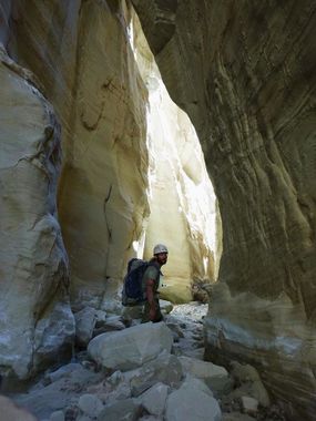
A short downclimb at the head of the canyon can be either done or hiked around on the right. Shortly afterward the canyon drops into a narrow slot that requires stemming about 20-25 feet off of the canyon floor for a distance of about 80 feet (or so). The stemming is easy enough as the top of the slot is a pretty good "V" to lock into, but the walls are sandy and at least one large block of sandstone appeared loose and requires caution to stem around it in case it gives way. At the end of the stemming section is an elevator downclimb of about 20 feet, after which the canyon seems to be completely filled in by a massive breakdown of boulders up to something like 60 feet deep - luckily, enough geological time has passed that the watercourse has carved a way under the boulders to allow passage. Climb down into the dark (a headlamp may be handy to see where you are going) to pass under the breakdown through a short tunnel. After the tunnel the canyon is easy walking and interesting, including one room that was only lit from a single beam of light through the boulders above. Too soon the canyon opens a bit and becomes completely choked with brush you must thrash through to get to its end. The brush is horrifyingly thick here, my approach was to stick to the wall so I only had brush on one side of me at any time, suffer it as best you can - follow the watercourse back to Wahweap Creek for the exit.
Exit[edit]
Return the way you came.
Red tape[edit]
Lone Rock beach requires a fee of $14 per day, per vehicle to stay or park at the campground. Since the campground is administered by the National Park Service, an interagency pass will cover it as well.
