Breitenbush River (South Fork North Fork)
| Rating: | |||||||||||||||||||||||||||||||
|---|---|---|---|---|---|---|---|---|---|---|---|---|---|---|---|---|---|---|---|---|---|---|---|---|---|---|---|---|---|---|---|
| | Raps:4-7, max ↨100ft
Red Tape:No permit required Shuttle:None Vehicle:High Clearance | ||||||||||||||||||||||||||||||
| Location: | |||||||||||||||||||||||||||||||
| Condition Reports: | 5 Sep 2025
"Very wild and untouched canyon run. Removed several old and very unsatisfactory anchors. Ghosted most of it so if I remember correctly we only left an |
||||||||||||||||||||||||||||||
| Best season: | Jul-Sep
|
||||||||||||||||||||||||||||||
| Regions: | |||||||||||||||||||||||||||||||
Introduction[edit]
Valhalla was overrun by the Lionshead Fire in Sept 2020 and is open. The road to get to the canyon from the 46 is closed to vehicle traffic. Use extreme caution when descending the creek. Between landslides, fallen trees, and loose rocks, this area may be unstable and dangerous for years to come. The canyon may have changed dramatically. Do not rely on the beta below being accurate.
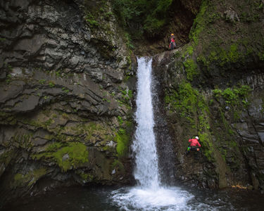
The South Fork North Fork Breitenbush River is located within Mount Jefferson Wilderness in Marion County, Oregon. It forms the boundary between Mount Hood National Forest to the northeast and Willamette National Forest to the southwest. A half mile section of the stream begins with two ~100 foot tall waterfalls in an amphitheater (one emanating from a tributary originating from Dinah-mo Peak and Bear Lake), followed by many small waterfalls and a narrow canyon. It was brought to widespread public attention by Oregon Public Broadcasting's Oregon Field Guide in February 2016.
- Do NOT underestimate this canyon. It's a step or three up from most other aquatic canyons in the area. The canyon can be overwhelming for beginners even with competent leadership. Be fully prepared. Expect a lot of water even when "low". Good navigation skills are required to get in and out.
Waterflow[edit]
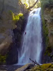
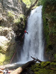
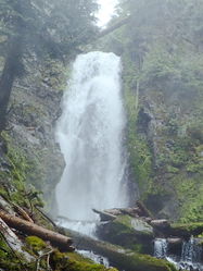
The typical best season is July-September, with high flows at the start of the season that mellow out as summer progresses. The reference pictures used below are of the first rappel, which may look similar to each other but show the waterfall with very different water densities. Keep in mind that the flow in the creek roughly doubles after this waterfall. If you find too much water after this rappel, you can still escape the canyon.
Approach[edit]
Drive[edit]
Access to the following roads is closed seasonally from 1 December to 1 April, and snow and other factors can prohibit access beyond the seasonal closure. Check with the U.S. Forest Service for updated road conditions.
From Detroit, Oregon, take Hwy 46/Breitenbush Rd 16.5 miles. Shortly after a sharp left switchback, turn right on unpaved NF-4220 (High clearance recommended but cars can make it if driven carefully.). Drive 4.4 miles, and look for suitable parking.
Hike[edit]
The route indicated on the map was first scouted by Karl Helser. It requires a small amount of bushwhacking at the start, and then goes across an open old burn, and finally down a very open hillside in mature forest.
Descent[edit]
Snowmelt can produce extremely high flow in the canyon that can make the descent very difficult and dangerous. Major undercuts are present where the stream sharply turns a corner; avoid these spots at all cost in high flow conditions.
The descent uses natural anchors, but keep in mind that conditions can change from year to year, and some anchors will be carried away by spring floods. Winter floods will rip through here and re-arrange everything. Therefore, teams (especially the first team each season) should be prepared accordingly with plenty of webbing, maillon rapides, and perhaps a bolting kit. Expect the unexpected, there may be the need for more rappels than the writeup indicates, in which case the canyon could take significantly longer than indicated.
R1: 25ft. tree L.
R2: 100 ft (30 m) from a large dead log spanning the river at the edge of the waterfall on DCR (down canyon right). This section of the canyon is very unstable with lots of loose rock. You will likely be in the full flow of the waterfall at times, although it is often possible to avoid most of it with skill. The pool at the bottom is not deep, so there are no issues with hydraulics.
- High water: Send down the most experienced canyoneer first, and set up a guided rappel for the rest of the team if desired.
Escape: escape is possible after R2 on DCR. Very steep scramble route. Beware loose rock.
R3: 20 ft (7 m) from a tree high on the slope DCR into a pool. This is in the full force of the water but the drop is short and the water doesn't have time to build much momentum.
R4: 15 ft (5 m) from the logjam at the edge of the pool.
R5: 50 ft (15 m) from a deadman anchor (will need to be rebuilt every season). This rappel is sometimes the crux of the descent, although depending on where the deadman is built it can be a dry rappel in lower flows.
- High water: There will be a VERY DANGEROUS hydraulic at the bottom of the waterfall, so make sure you rappel on canyon left where the flow is less!
(NOTE: Anchoring the Deadman on the natural L side will put you almost completely out of the flow and away from any hydraulics- if any actually exist.)
R6: 30 ft (10 m) from a semi exposed tree at the edge of the falls on DCL. It is recommended to make a handline belay to reach the tree and then rappel from there.
More: all of the other waterfalls and logjams along the route are more or less downclimbable or bypassable, but you may also build anchors and rappel these in low to moderate flow. They will be impossible or very dangerous to tackle in high flow.
R7: There is one particularly difficult and exposed DC down a log (then crawling behind the falls) towards the end that most would choose to rappel off a log anchor on DCR. In extremely high flows (probably at least 160-180cfs) this could be a dangerous strainer.
Exit[edit]
Now you earn your day by finishing with a 1600' exit climb.
Follow the route indicated on the map to hike back to the parking area. Make sure you wait to turn the corner before starting your ascent, or you will get cliffed out. Do not go up the obvious big talus/dirt slope or you will get cliffed out with extremely loose and dangerous rock and dirt. Above the cliffs you will be in in open, mature, and easily walkable (but steep) forest for most of the climb out. The final ~0.4mi crosses large talus on with an old burn and then finishes with a bushwhack for the last part before the car.
Red tape[edit]
Free, self-issue wilderness permits are required for all entry to the Mount Jefferson Wilderness, which includes the canyoning route, from the Friday of Memorial Day weekend through 31 October. The permits are usually available at wilderness trailheads, and they help the USFS during search and rescue, and to track use trends. For more information, contact or visit the Willamette National Forest Detroit Ranger District Office.\
Visitors to the Mt. Jefferson Wilderness require a Central Cascades Wilderness Permit for all overnight use and some day-use between June 15 and Oct. 15.
Beta sites[edit]
- "Shangri-La (Dinah-Mo Falls) Hike". Outdoor Project. Retrieved 27 Feb 2016.
Trip reports and media[edit]
"Discovering Valhalla: Oregon's Secret Gorge". Oregon Public Broadcasting. Retrieved 1 Feb 2016.
 Karl Helser's NW Adventures : South Fork North Fork Breitenbush Canyoneer 6-27-16
2025 Visit https://youtu.be/jMnZe1Q5Fxg?si=ws0_5xs2hYsy31Y7
Background[edit]
"Mahogany Aulenbach, who lived at Breitenbush Hot Springs, first visited the area in 1986. He backpacked into the area and was intrigued enough by what he saw to continue his exploration over the years. A couple of trips later, he and friends Reed Wilson and Garde Wells rappelled into the “Shangri-La” big waterfalls area and named the southwest falls “Dinah-Mo Falls” in honor of ancient forest activist Dinah Ross."[1]
On 31 July 1992, members of Corvallis Mountain Rescue responded to a search and rescue callout for a missing hiker. Seven CMR personnel traveled up the SFNF Brietenbush River and spent a night in the canyon.[2]
In 2010, Mike Malone, a United States Forest Service employee (now retired), was flying in a helicopter while responding to a wildfire and spotted the canyon from the air. He took note and later returned on foot, hiking up the SFNF Breitenbush River from below the canyon, and made it a little farther upstream on each trip. He then contacted Oregon Public Broadcasting in 2014, and Malone and a crew from OPB investigated the area further and planned a descent. On 24-31 July 2015, a five-person team (Brian French, Jared Smith, Benjamin Trapanese, John Waller, and Mike WIlliams), assembled by OPB, descended the half mile technical section of the canyon over the course of three days, documenting the descent on film. Turns out, Malone was unable to make the descent but hiked to meet the team below the technical section.[3]
References[edit]
- ↑ Gilfillan, Jule; Rosman, John. "Secret's Out! Have You Been To Valhalla?". Oregon Public Broadcasting. Retrieved 5 February 2016.
- ↑ Keltner, Mardi. "The Search for Jonathan Korn". Corvallis Mountain Rescue. Retrieved 27 Feb 2016.
- ↑ Burns, Jes; Rosman, John. "Discovering Oregon's Secret Canyon". Oregon Public Broadcasting. Retrieved 6 February 2016.


