References:Breitenbush River (South Fork North Fork)-20160708213931

From ropewiki.com
Jump to navigation Jump to search
  • Breitenbush River (South Fork North Fork)-20160708213931 pic.jpg
  • Location: Breitenbush River (South Fork North Fork)
    Reported by: Lucach
    Date: 28 Jul 2015
    Comment: Extracted from Documentary
    Waterflow: Moderate
    Very Low Low Moderate-Low Moderate Moderate-High High Very High Extreme
    0% - 40% 40% - 70% 70% - 90% 90% - 110% 110% - 130% 130% - 160% 160% - 200% >200%

    • Very Low: Water flow should not represent any danger (class B = a2).
    • Low: Not as fun, but should be safe even for beginners (class B/C = a3).
    • Moderate-Low: A bit low, still fun but not very challenging (class C1- = a4-).
    • Moderate: Challenging but not dangerous for intermediate canyoneers (class C1 = a4).
    • Moderate-High: A bit high, quite challenging but not too dangerous (class C1+ = a4+).
    • High: High water, only for experienced swift water canyoneers (class C2 = a5).
    • Very High: Dangerously high water, only for expert swift water canyoneers (class C3 = a6).
    • Extreme: Extremely dangerous high water, may be unsafe even for experts (class C4 = a7).

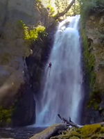
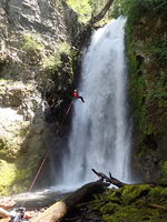
    Historical reference pictures used in Waterflow analysis


    (log in to submit reference picture)

    28 Jul 2015
    Moderate
    27 Jun 2016
    Very High
    21 May 2016
    Extreme
    Breitenbush River (South Fork North Fork)-20160708213931 pic.jpg Breitenbush River (South Fork North Fork)-20160708205734 pic.jpg Breitenbush River (South Fork North Fork)-20160708212607 pic.jpg