Burns Gulch
| Rating: | |||||||||||||||||||||||||||||||
|---|---|---|---|---|---|---|---|---|---|---|---|---|---|---|---|---|---|---|---|---|---|---|---|---|---|---|---|---|---|---|---|
| | Raps:3, max ↨150ft
Red Tape:No permit required Shuttle:Optional 1.7mi Vehicle:4WD - High Clearance Rock type:Tuff and Andesite | ||||||||||||||||||||||||||||||
| Start: | |||||||||||||||||||||||||||||||
| Parking: | |||||||||||||||||||||||||||||||
| Shuttle: | |||||||||||||||||||||||||||||||
| Condition Reports: | |||||||||||||||||||||||||||||||
| Best season: | Jul-Sept, BEST Jul
|
||||||||||||||||||||||||||||||
| Regions: | |||||||||||||||||||||||||||||||
Introduction[edit]
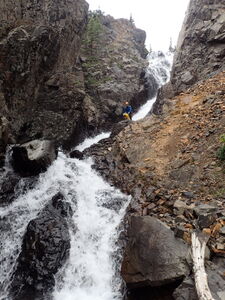
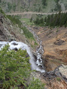
Burns Gulch offers three interesting rappels in an easy to access short drainage with a car shuttle.
Approach[edit]
Drive 10 miles from the center of Silverton on CR2 next to the Animas River to park a shuttle vehicle across from Burns Gulch. The dirt road gets rougher past Eureka.
To set up a Shuttle, continue 0.7 miles on CR2, then drive across the Animas River on Burns Gulch Road, a rougher section of single lane dirt requiring high clearance four wheel drive.
Park the Shuttle Vehicle 1.0 mile up Burns Gulch Road where the drainage levels out. This saves 500' of elevation gain.
Hike 300ft slightly downhill to the South to intersect the drainage.
Descent[edit]
R1: 85' from a tree on Canyon Left
R2: 150' from a rock in Canyon Center
After a first 20' falls, which the rappel may be next to based on the anchor, the water snakes through a low angle trough. Beware possible foot entrapment, which can be avoided by carefully selecting stemming foot placements. This section is the crux of the canyon as all the waterflow is this one location and the reason why the season was listed to start in July after most of the snowmelt rather than June.
R3: 120' from a tree on Canyon Right, shared as an ice climbing anchor
Exit[edit]
From the bottom of R3, continue down the scree field next to the watercourse. Either walk an old road, still on the East side of the Animas River, back to the dirt 4x4 Burns Gulch Road, or hike across the Animas River and up the short hill back up to CR2.
Red tape[edit]
Beta sites[edit]
Trip reports and media[edit]
13 Jul 2024: First known summer descent, evidence of ice climbing anchors. Ira Lewis, Wayne Herrick, Carl Bern


