Butterbox Canyon
| Rating: | |||||||||||||||||||||||||||||||
|---|---|---|---|---|---|---|---|---|---|---|---|---|---|---|---|---|---|---|---|---|---|---|---|---|---|---|---|---|---|---|---|
|
| |||||||||||||||||||||||||||||||
| | Raps:6-11, max ↨66ft
Red Tape:No permit required Shuttle:None Vehicle:Passenger Rock type:Sandstone | ||||||||||||||||||||||||||||||
| Start: | |||||||||||||||||||||||||||||||
| Parking: | |||||||||||||||||||||||||||||||
| Condition Reports: | 31 Dec 2025
"There are currently four bolts (including 1 access bolt) on the jump/tree chockstone. Easy to reach with 2 bolts linked with a long section of chain a |
||||||||||||||||||||||||||||||
| Best season: | Nov - Mar
|
||||||||||||||||||||||||||||||
| Regions: | |||||||||||||||||||||||||||||||

Introduction
Butterbox (a.k.a. Mt Hay) canyon is a very popular Blue Mountains classic canyon and is a great short day out. Its highlight is the "chockstone" abseil where you land on a large chockstone wedged between the canyon walls. The common exit features a ~15m Ewbank grade 16 rock climb requiring lead climbing skills and 5 quickdraws.
Butterbox is regularly run by commercial groups, and is a very good option if you have some canyon experience.
The climb out can get very "busy". The cliff is hot, some participants are stressed by the exposure and the climb, while others are frustrated by the pace of those ahead of them. Please maintain considerate and safe behaviour.
Quality
- The canyon is rated 6 out of 10 on the Brennan Quality Scale.
- David Noble rates the canyon 4 out of 5 for quality and Medium-Hard for difficulty.
- 2 stars (regionally significant) in the French Federation of Mountain Climbing (FFME) grading system
Water levels
- In typical conditions Butterbox is a2 to a3
- The catchment for Butterbox is approximately 5 km²
- The canyon features a narrow chute (P8 in the canyon topo) where all water is funnelled through. This concentrates the water and in higher flow into a powerful jet. In higher flow conditions (after significant rain) this feature may require implementing more advanced SRT canyoning techniques to safely navigate e.g. a guided rappel
- A very inaccurate but sometimes relevant reference can be taken at the Grose river gauge a long way downstream with a ~668 km² catchment. >400 ml/d (4.63 m³/s) usually means some heavier rain somewhere in the valley. It can take >12 hours for the gauge to reflect events in Grose's headwaters
Approach
By car
- Park at Mt Hay carpark as per above
- The dirt road to the carpark is easily damaged by rain and use-related wear, and may require an AWD/4WD
- Check Mount Hay Road for closures/current road conditions
By foot
- Refer to the GPX via Gaia GPS (Gaia app not required - allows you to download the GPX file from browser)
- Route and waypoints in the GPX file are approximates only! GPS tracking in canyons is notoriously unreliable.
- The entry is a short well worn path
- In the attached canyon topo the canyon starts with the technical down climbs straight after the "trip intentions log"
- The entry down climbs may require "spotting" of your team members and passing packs
Descent
Proceed down canyon referring to the Butterbox Canyon v4a2III canyon topo for details on problems you will encounter along the canyon
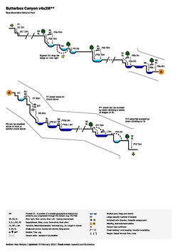
- P6a: New bolted mega-anchor + access bolt on the chockstone, replacing the previous dying tree abseil anchor (which appears to have a beetle infestation).
- P8: Now has a river left option - 2*anchor bolts + 1*access bolt in addition to the river right older bolted anchor. The new RL anchor is a very clean drop and is likely to have a lower risk of getting a rope stuck on pull down compared to RR (the V-goove between chockstone and wall).
Exit
- River right, about 20m downstream of the last abseil (P13)
- Start going up the obvious small gully for a few meters, then turn left. As of 12/2025 there's a fairly easy to follow track that follows the cliffs NW, NE through a steep gully, then eventually turns SW (up at arrow) towards the climb. About 45 min at a slow pace.
- Following a traverse along a small cave with several fixed hangers to the base of a rock climbing section that requires lead climbing skills.
- The ~15m bolted rock climb has 4 fixed hangers and a U bolt, finishing a double bolt belay - no bolt plates required. Graded Ewbank 15 [1].
- After the climb, turn climbers right then up the short steep and somewhat loose trench in the gully past 2 glue in P bolts. Continue on well established path back to carpark.
- The alternative (rarely done) non-climbing exit involves following the creek down to the Grose River, walking upstream on the Grose to the Blue Gum Forest, and then up the Lockley Pylon Track back to the Pinnacles.
Red tape
- Butterbox/Mt Hay canyon is commonly commercially guided.
- Due to it's popularity the canyon will often have multiple parties in it on the weekend. Be considerate of other parties and if possible let faster parties pass.
Beta sites
- Mt Hay Canyon - OZultimate.com
- Mount Hay canyon exit - The Crag
- Butterbox Canyon - NSW National Parks and Wildlife Service
- Butterbox - Descente Canyon
Trip reports and media
 YouTube.com : Richard Pattison, Mount Hay Canyon movie
Background
David Noble says: First descent probably by an Institute of Technology Bushwalking Club Party in the mid fifties (Bob Holmes et al). This was prior to a descent by the Catholic Bushwalking Club in 1958. The CBC had tried to go up the creek in 1952 and explored the area from below. On one trip, they forced a pass up Butterbox Point - this may have been the same pass found by Tom Williams on a trip with Bob Sault and Dave Noble and others in Dec 77.
A trip report of the first confirmed ascent of the now standard exit can be viewed here (led by Tom Williams on Christmas Eve 1977): https://www.subw.org.au/archives/press-on-regardless/mt-hay-canyon/