Cañon Azul Turquesa
| Rating: | |||||||||||||||||||||||||||||||
|---|---|---|---|---|---|---|---|---|---|---|---|---|---|---|---|---|---|---|---|---|---|---|---|---|---|---|---|---|---|---|---|
|
| |||||||||||||||||||||||||||||||
| | Difficulty:3B II (v4a2 III) Raps:7, max ↨69ft
Red Tape:No permit required Shuttle:Optional 0 min Vehicle:Passenger Rock type:Rhyolite | ||||||||||||||||||||||||||||||
| Location: | |||||||||||||||||||||||||||||||
| Condition Reports: | |||||||||||||||||||||||||||||||
| Best season: | Oct-Jun
|
||||||||||||||||||||||||||||||
| Regions: | |||||||||||||||||||||||||||||||

Introduction[edit]
! * * * as of February 2021, this canyon is not recommended due to large amounts of trash being periodically dumped into it * * *
This canyon is located about 30 minutes N of Guadalajara and is developed in beautiful sculpted rhyolite. the approach hike is over an open field that then drops down into a very tall and enclosed canyon. The standard trip does the first 7 rappels, and then cuts out on the left, to hike back up to the car (which avoids a 2 hour car shuffle if wanting to to the whole canyon).
Approach[edit]
Take the road out of Guadalajara towards Tesistan, then turn right onto the highway 23 towards San Cristobal de las Casas for 13.3km. Turn right into the village Lomas de Montechelo, and follow the road another 2.3km. to a right turn, and then follow the electric line until a closed gate. Park there and then walk 700m down to the SSE, to get to the first rappels.
Descent[edit]
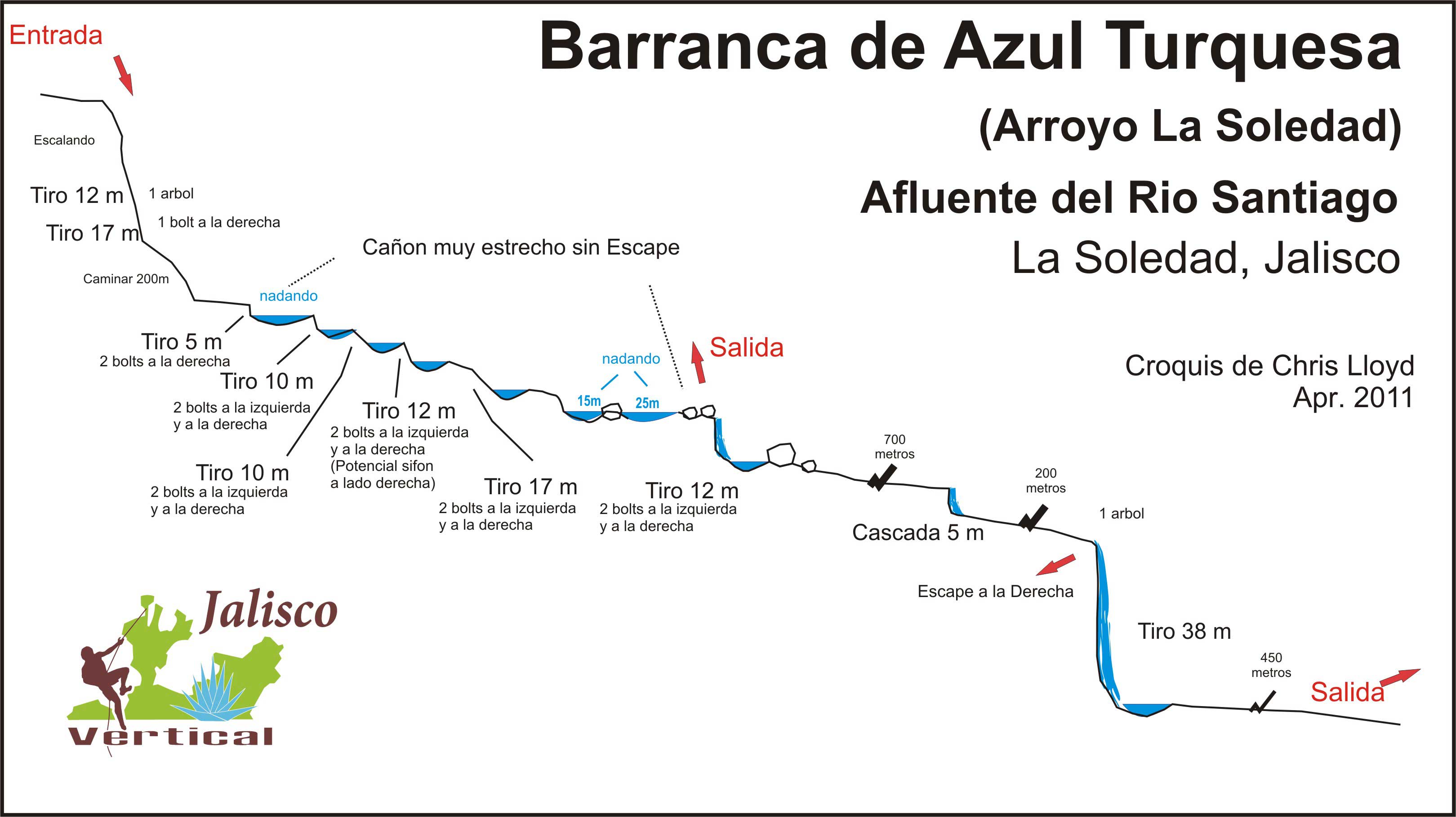
R1 15m - 1 tree r. (dry)
R2 21m – 2 bolts l. (dry)
R3 5m - 1 bolt r. & 2 l. or Jump down the crack on right, below the bolt (but face into center of canyon)
R4 9m – 2 bolt center (not very useful). & 2 bolts r.
R5 9m –2 bolts l. & 2 bolts r.
R6 14m – 2 bolts l. (for lower water levels) & 2 bolt r. (for high water levels)
R7 15m – 2 bolts izq. (low water) & 2 bolt r. (high water)
R8 12m –2 bolts l. & 2 bolts r.
r1 5m – or walk to one side
R9 38m – From tree.


Exit[edit]
The normal exit is to get out on the left after the 25m swim after R7, and before going down R8. Take this steep climb up, and return to your car in about 40 minutes.
Red tape[edit]
Beta sites[edit]
 JaliscoVertical.Weebly.com : AZUL TURQUESA
Trip reports and media[edit]
Background[edit]
This canyon was explored and rigged by Cañones en México A.C. (CEM y DDB) in November, 2009 by Jose Navarro, Ismael Escoto Valencia, José Benavides, Christian Becerra, Iván Nava, Christian Gerber, Diego del Rio, Arturo Prado.