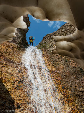
Canyon of the Clouds
| Rating: | |||||||||||||||||||||||||||||||
|---|---|---|---|---|---|---|---|---|---|---|---|---|---|---|---|---|---|---|---|---|---|---|---|---|---|---|---|---|---|---|---|
| | Raps:4, max ↨100ft
Red Tape:No permit required Shuttle:None Vehicle:4WD - High Clearance Rock type:San Juan Volcanic Tuff | ||||||||||||||||||||||||||||||
| Location: | |||||||||||||||||||||||||||||||
| Condition Reports: | |||||||||||||||||||||||||||||||
| Best season: | Jul - Sep
|
||||||||||||||||||||||||||||||
| Regions: | |||||||||||||||||||||||||||||||
Introduction[edit]
This canyon is entirely above treeline, in the fragile alpine tundra life zone. In addition, the slopes and canyon walls here are rotten and very crumbly. A misplaced footstep or a poorly planned anchor will damage this canyon and the adjacent slopes, and damage from one canyoner can be enough to require decades of restoration.
Do NOT go around any of the drops and do NOT exit/enter the canyon midway unless you are having an emergency. Even one person bypassing a drop will create an unsightly social trail that will not only take decades to heal, but its presence will encourage others to take it, causing even more damage.
Anchor building is difficult here. There are no logs or trees to sling - it is all rock stacks, and there aren't a lot of large rocks to choose from. Resist the temptation to go around a drop. Do not come here if you aren't skilled in building difficult anchors, especially without using trees and logs.
This canyon, more than just about any other, is in danger from recreational use. The Forest Service is watching it to see just how respectful canyoners can be. This canyon is your chance to show land managers that we can recreate in the outdoors with a high regard towards nature, putting the resource first. You must practice leave-no-trace here in every step you take, in every anchor you build, and in every rappel you descend. If you can not do this, or if you aren't sure, or if you have no formal training with leave-no-trace techniques, skip this canyon.
Starting at a trailhead elevation of just under 10,700 feet and hiking up to the drop-in at a hair under 12,400 feet, this canyon requires high-altitude fitness. While the gain is only 1,700 feet and typical for canyon routes in the San Juan Mountains, the top elevation of over 12,000 feet may affect some. If coming from sea level, best to acclimitize a few days before attempting this route.
The views are phenomenal. Above timber line. It is easy to see how this canyon got it's name.
The "4" rating is due to the anchor building requirement. You can assume that there will be no anchors and any previous anchors will be washed away as they are all in the watercourse. There is scant material to work with. You must be confident in building deadman anchors in the watercourse.
The "R" rating is due to the snow tunnels you must either tunnel through or walk on top of. They do not appear every year. If they cave in you will have only precious minutes to escape from the frigid water before hypothermia sets in. The snow tunnels and literally freezing water temperatures represent a special risk. Another risk worth mentioning is rock fall. All of the canyon walls and floor are brittle and easily flake off into little scree shards that are ubiquitous and also very sharp.
Approach[edit]
Park at the Rico-Silverton Trailhead, at the end of County Road 7 that runs past South Mineral Campground in Silverton. From Ouray Hot Springs Park, drive south on Highway 550 for 21.5 miles. Make a right on CR7. There is a sign for South Mineral Campground. It is a 7 mile drive on the dirt road. After South Mineral Campground, high-clearance is required.
Hike up the Rico-Silverton trail from the starting elevation of 10,700ft across a tributary, then up and through South Park until you reach a creek crossing at an elevation fo approximately 11,800 feet. Here, go off-trail and follow the creek up to the 12,400ft level.
Descent[edit]
It looks like you are on the surface of Mars. Well above treeline. In a barren scree canyon. Rock fall is a serious concern here. Remember, Leave-No-Trace techniques are imperative. Follow them; live them!
You may encounter snowfields above 12,200ft. Find a way down into the watercourse at about 12,400ft. If all of the potential drop-ins are covered by a large snow field, you may have to glissade down to the watercourse, being careful not to put too much weight on the roof of the snow tunnel when you slide onto it.
You may need to build all anchors from the scant material available. Meat-anchor all but the last rappeller in each case.
R1: Boulder pinch point, mid-watercourse, 100 foot rappel, top 50 feet low-angle, bottom 50 feet near vertical. Elevation 12,200 feet. You may be descending into a snow tunnel.
R2: Deadman, mid-watercourse, 47 foot rappel.
R3: Deadman, mid-watercourse, 50 foot 2-stage rappel, lively rock fall. Take extra care on rope pull due to rock fall.
R4: Deadman, mid-watercourse, 90-foot rappel, 60-feet above the lip, then 30-foot drop. Do NOT walk around this drop, tempting as it may be. The damage you cause will take decades to heal, and the social trail you leave will encourage others to come here and damage it even more. Let the existing impact from inconsiderate canyoners bypassing this drop heal. You are here to rappel down a canyon, not walk around the drops. So rappel!
Exit[edit]
Once you are below the technical section, at 12,000ft, best to keep your wetsuit on and creek your way down to the trail itself. The rocks in the watercourse are surprisingly grippy, probably due to the calcium carbonate.
Once you reach the trail, there is a nice space to change out of your gear. Head down the trail which takes about 45 minutes.
