Cascadas Micos
| Rating: | |||||||||||||||||||||||||||||||
|---|---|---|---|---|---|---|---|---|---|---|---|---|---|---|---|---|---|---|---|---|---|---|---|---|---|---|---|---|---|---|---|
| | Raps:0-2, max ↨30ft
Red Tape: Shuttle: Vehicle:Passenger | ||||||||||||||||||||||||||||||
| Location: | |||||||||||||||||||||||||||||||
| Condition Reports: | 21 Nov 2024
"Visited alone and hired a guide (wore my own canyoning helmet that I had with me). Flow was higher than Id had here before, and the water was warm an |
||||||||||||||||||||||||||||||
| Best season: | oct-july, BEST nov-apr
|
||||||||||||||||||||||||||||||
| Regions: | |||||||||||||||||||||||||||||||
Introduction[edit]
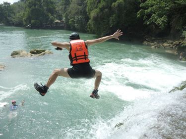
This is a wide river descent having around seven gorgeous travertine waterfalls that can all be jumped. It is also a very popular tourist activity, with local guides always available for hire at the base of the route. Also at the base of the route are a couple restaurants, souvenir shops, lockers for your stuff, changing rooms, and bathrooms. At the parking area about 100 yds up the hill, there are more restaurants and shops.
Feb 2022 fees (per person): 100 pesos to enter the park. 250 pesos for a guide down the waterfalls (including photos).
Approach[edit]
After parking at the official parking lot, walk down the obvious path to the swimming hole village complex. Hire a guide and after changing into proper gear proceed on foot for half a mile along the road and down a set of stairs to reach the bottom of the big falls. One may also start the canyon from further upstream, but then technical gear is mandatory to descend the big falls, unless you want to jump 80ft.
Descent[edit]
It is recommended to visit the big falls from the bottom and explore the multiple caves that hide behind its veil, they are very cool. After that the descent is pretty much the same: jump, jump, jump! Some waterfalls further down also have cave complexes behind them and it's very interesting to explore (ask your guide to show them to you).
Exit[edit]
The descent terminates at the swimming hole village
Red tape[edit]
The local guides will warn you must hire a guide to do the descent, but this is not really enforced by any official regulation.
