Cascade Creek (Durango Waterpark)
| Rating: | |||||||||||||||||||||||||||||||
|---|---|---|---|---|---|---|---|---|---|---|---|---|---|---|---|---|---|---|---|---|---|---|---|---|---|---|---|---|---|---|---|
| | Raps:4 jumps, max ↨18ft
Red Tape:No permit required Shuttle:None Vehicle:Passenger Rock type:sandstone, siltstone | ||||||||||||||||||||||||||||||
| Location: | |||||||||||||||||||||||||||||||
| Condition Reports: | |||||||||||||||||||||||||||||||
| Best season: | Jul-Sep
|
||||||||||||||||||||||||||||||
| Regions: | |||||||||||||||||||||||||||||||
Introduction[edit]
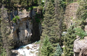
Located at the bottom of Coalbank Pass, Cascade Creek offers a fun, short, slot canyon experience with minimal approach and exit. The views are beautiful as you downclimb and jump several 8 to 15-feet drops through the slot. There are basically 4 obstacles that are either jumps, slides, or rappels, depending on conditions.
This canyon is very short, only 0.1 miles, so it should not be considered a destination by itself. However it is an excellent option when doing some of the other canyons in Silverton, such as South Fork Mineral Creek. Competent small groups may run the whole canyon in 30 minutes, with the descent taking about 15 minutes, and many will choose to run it twice or more.
You may see locals going through in shorts and girls in 2-pieces and barefoot without any gear and wonder why it's rated 3CI and not 2CI. That's because you have to bring a rope to send the first person down each obstacle on rappel to test water depth. If you happen to be behind a group and can see where they are jumping, then you are probably okay to do the same, but the canyon rating would still be a 3.
People have been killed in this canyon, getting swept away when the water levels are too high - especially during the runoff season. The waterflow checkpoint is at the start of the descent, where a large dead tree crosses the span of the creek. The canyon you see at this point is wide, it gets narrow down to 5 feet wide later. If you are not comfortable with the amount of water you see at the start of the canyon abort the descent.
Approach[edit]
From Ouray Hot Springs Park drive south on Highway 550 for 23.5 miles to the only gas station in Silverton, on the right side of the highway. From the Silverton gas station, continue another 19.3 miles south on Hwy 550 where you will see a sign for Old Lime Creek Road. Make a left and park in a large dirt parking area.
CHECK USGS GAUGE!!! There should be cell/data service either at the TH or at Purgatory. https://waterdata.usgs.gov/co/nwis/uv?site_no=09359082 If its above 25 cfs, you should have life jacket, helmet, wetsuit, and swift water skills before proceeding!!! Would not recommend above 50 cfs.
Most waterfalls can be seen from trails above the canyon on the north side. Be sure to see as much of the canyon before committing. There can be new logs or higher levels after rain events at any point of the season.
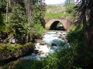
There is an obvious use-trail heading down to the creek level just downstream of the massive culvert where Cascade Creek flows under the highway. This is your watercourse. Before hiking down, you might want to gear up in wetsuit, etc., as the hike down is less than 5 minutes.
Descent[edit]
Several of the jumps can be done higher or lower by climbing up on rock edges. The slides can also be jumped. Always check the depth or watch other groups in front of you to avoid messing up the landing.
Jump 1: Within a few minutes of starting to creek your way down. To avoid a slide into a big rock, climb up on the left side. There, you see jump of less than 10 feet height. Usually shallow, jump right in the middle of the camber. (2021 Theres a tree sticking right in middle, jump to slight left)
Slide 1 or jump: The slide (5 feet), is on canyon just left the watercourse. May be climbed on left then jumped as well with the proper form at about 10 feet high. The water depth was about 8 feet deep right at the white-water froth in the narrow grey camber.
Update 7/5/21. A submerged logs in the middle of a twisted section of next slot. After slide 1/ jump 2 go down a short subway corridor carefully. Stay high on the left to avoid the current sweeping you into the above mention strainers. After the logs are past you either jump (6 ft) on high left, or slide/ float if the current is high enough. Walking also works fine. Then stay right and stay out of water course to scope out next feature.
Waterfall (Mandatory at higher levels): Yellow and orange rock is the setting for the next major drop. Usually jumped from a high right ledge either at or above water level. Jump out and right to the outside edge of big boil. At higher levels, the bottom of this waterfall can act as a dangerous hydraulic. Be sure to jump out. When levels are lower, one can simply slide down the right side ramp into the water.
After this feature, you are in a huge, loud cave like camber. Make your way down and stay high to the right. The next drop is usually jumped from a higher ledge on the right side. This drop doesn't make for a great slide and the water level below the right ledges is almost always bottomless. the Drop ranges from 12-25 ft depend on what ledge you jump off.
Final waterfall and mandatory jump: A 15 feet jump into a large pool that is usually deep enough to not feel bottom. There is a shelf underwater canyon left that jutts out about 3 feet so be sure to jump out to clear this. It should be visible.
Exit[edit]
After the last drop and the canyon narrows open up, exit Canyon Left (north side) and use the climber's trail to return to the dirt Lime Creek Road and walk back to your car parked closer to the bridge.
Red tape[edit]
Beta sites[edit]
- https://waterdata.usgs.gov/co/nwis/uv?site_no=09359082 - USGS watergauge- A "safe" waterflow is 25 cfs and under. Usually by August.
- https://durangoherald.com/articles/106569 A 19 year women drown when the creek was 90 cfs
- http://theknow.denverpost.com/2017/08/25/cliff-jump-waterfall-durango-colorado-safety/155150/
The ABCs — Adrenaline, Baker’s Bridge and Cascade — are southern Colorado’s natural water parks:
- Adrenaline is tucked off Old Lime Creek Road. A short, steep hike takes you to an approximately 18-foot-tall waterfall thundering into a deep pool. You can climb up beside the falls, perch anywhere from 15 to 40 feet above the water and jump from where you feel comfortable. http://ropewiki.com/Adrenaline_Falls
- Baker’s Bridge is located where Old Shalona Road crosses the Animas River. It’s where Paul Newman and Robert Redford jump from a cliff into a river in “Butch Cassidy and the Sundance Kid.” (Through editing, they land in a different river, not the Animas, in the film.) Jumping from this bridge isn’t just dangerous — it’s illegal. Instead, people climb down to nearby cliffs of various heights — as high as 17 feet — and jump from there. http://ropewiki.com/Bakers_Bridge
- Cascade isn’t just one jump. It’s a run through a slot canyon, with mountain runoff providing a series of natural water slides and waterfalls to jump. Once you enter Cascade, you’re committed to being in cold water for about half an hour. http://ropewiki.com/Cascade_Creek_(Durango_Waterpark)
- http://www.verdepr.com/2013/05/10-things-to-love-about-a-durango-summer/ Things-To-Beat-The-Heat-In-Durango article
At the bottom of the canyon:
- http://www.mountainproject.com/v/cascade-canyon/105827468 : Summer Sport Climbing is on the north side:
- http://www.mountainproject.com/v/cascade-creek/105747106 : Winter Ice Climbing is on the South Side


