Cascade Falls (Macquarie Pass)
| Rating: | |||||||||||||||||||||||||||||||
|---|---|---|---|---|---|---|---|---|---|---|---|---|---|---|---|---|---|---|---|---|---|---|---|---|---|---|---|---|---|---|---|
| | Difficulty:4B (v4a2 I) Raps:0-7, max ↨121ft
Red Tape:No permit required Shuttle: Vehicle:Passenger | ||||||||||||||||||||||||||||||
| Start: | |||||||||||||||||||||||||||||||
| Parking: | |||||||||||||||||||||||||||||||
| Condition Reports: | 14 Nov 2023
"Cascade Falls v3A2l. - R6, R7 needs sling replacement. Didnt have any rated slings to replace them. - R1 someone tied a dodgy looking water kn |
||||||||||||||||||||||||||||||
| Best season: | Oct-Apr (avg for this region)
|
||||||||||||||||||||||||||||||
| Regions: | |||||||||||||||||||||||||||||||
Introduction[edit]
Cascade Falls is a short and sweet series of waterfalls that can be descended quite quickly. A great training canyon for beginner canyoners or a nice run for more experienced canyoners who only have a few hours to spare. Super-easy access, short walk-in/out. Some get-fully-wet abseils, potholes and pools, but easy to drip off / warm up on open slabs between abseils so can be done in cooler weather. Can easily walk out from most drops, so ideal for beginners who may be cold or don’t want to abseil further. Very good for teaching/practicing canyon rigging.
Approach[edit]
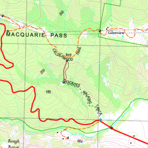
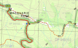
The path up the RL (right side going up) may or may not be closed (try asking on the Facebook groups). The cascades can be approached from the Calderwood trail to the northwest, as shown on the location map.
If parking on the pass at the start of the Calderwood trail it is highly recommended to park at the upper trail (purple star on above map), not at the lower trail (blue star) to avoid aggravating the locals. Also there is very little parking at the lower (blue star) location.
Descent[edit]
A series of 7 drops with various anchors, most placed to get you wet All abseils are optional and can be walked around Some of the drops land in deep-ish wet “potholes” and can be a little tricky to traverse
| Abseil Number | Metres | Anchor Type | Anchor Location | Notes |
|---|---|---|---|---|
| 1 | 22m | Sling | RC | Sling off boulder (reach under the boulder). Stepped abseil with 3 potholes in a row |
| 2 | 37m | Bolts | RC | |
| 3 | 15m | Bolts | RC | |
| 4 | 25m | Bolts | RR | |
| 5 | 15m | Sling | RR | Sling off tree |
| 6 | 15m | Sling | RR | Sling off tree. Can be jumped (check depth) |
| 7 | 30m | Sling | RC | Sling off boulder in stream (look under boulder) |
Exit[edit]
From the base of Cascade Falls walk back along the Cascade Walking Track to the Cascade Falls Parking spot
Red tape[edit]
Beta sites[edit]
- https://canyoning.org.au/forum/viewtopic.php?f=18&t=799
- https://www.nationalparks.nsw.gov.au/things-to-do/walking-tracks/cascades-walk


