Chalk Creek
| Rating: | |||||||||||||||||||||||||||||||
|---|---|---|---|---|---|---|---|---|---|---|---|---|---|---|---|---|---|---|---|---|---|---|---|---|---|---|---|---|---|---|---|
| | Raps:1, max ↨65ft
Red Tape:Closed to entry Shuttle:None Vehicle:Passenger | ||||||||||||||||||||||||||||||
| Location: | |||||||||||||||||||||||||||||||
| Condition Reports: | |||||||||||||||||||||||||||||||
| Best season: | Jun-Sep
|
||||||||||||||||||||||||||||||
| Regions: | |||||||||||||||||||||||||||||||
Introduction[edit]
Original beta by Michael Dallin recopied to ropewiki:
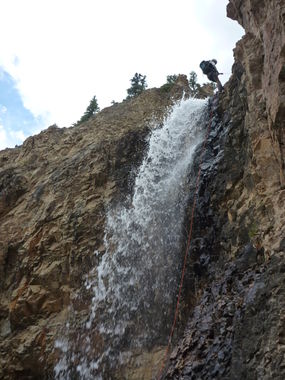
This is a stunt rappel. It is a good one. Don't use ice-climber bolts high on canyon right as it will keep you out of the falls and is very sketchy traverse to reach for a canyoneer.
Chalk Creek Canyon - not to be confused with the more well known Chalk Creek Canyon that flows off of Mt Princeton to the south - drains a quiet alpine valley near the monstrous environmental disaster known as the Climax mine. The drainage is mostly open and rocky, but it does contain one spectacular rappel down Chalk Creek Falls.
A full wet suit is recommended, as the water is very cold, especially at Chalk Creek Falls. It should only take an hour or two to descend.
Approach[edit]
To get there, take Highway 91 south from I-70 (at the exit for Copper Mountain ski resort). Drive past large mine tailing dumps to the Climax Mine, at Fremont Pass. Continue down the other side. Exactly 3.0 miles down the road from Fremont Pass, a dirt road turns off to the right. Turn onto this road, and you'll immediately find a sign warning the need for high clearance 4wd to continue. Drive up the road for 0.2 miles. It is bumpy and a little steep, but should be passable for most 2wd cars with normal clearance. After an uphill section, the road turns to the right, and flattens out. Park here. To the left (west) you'll see an obvious rock cut, what was once an old road or possibly a ditch. Now it is overgrown, though there is a foot path through it. If you follow this path for 5 minutes, you'll reach a great overlook of Chalk Creek Falls. Return to your car.
Grab your gear and hike up the road. If you want to drive up you can, but you will need 4wd past this point. The road enters a light forest after a quarter mile or so, but opens up again shortly. After it opens up, look to the left towards the creek. Find an easy place to descend to the water level.
Descent[edit]
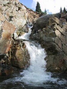
Hike and boulder hop down the stream. There are a few interesting cascades, 6 to 8 feet high, but for the most part the stream is open and boulder-strewn. There are some surprisingly deep pools below the cascades, some more than waste deep, but none deep enough to jump. Eventually you'll reach the top of Chalk Creek Falls, and here the real fun begins.
Sling a bomber tree a few feet from the edge. You'll need a 50 meter rope for this rappel. Once over the edge, you'll be in the falls - and this waterfall will really pound you, so wear a helmet! Don't try this in heavy water flow. Part of the rappel is free-hanging. There is an alcove behind the falls, and 2/3 of the way down you can stop there and step behind the falls. Continue down to the pool at the base of the falls, which is only knee deep.
Exit[edit]
The watercourse below the falls is not interesting. Instead, climb up a steep dirt slope opposite the falls to reach the overlook. Hike the faint trail through the rock cut back to your car.
Red tape[edit]
From Mountain Project: "As of 2015, this area is closed to the public. Any past permission that was granted has been revoked. Certain [ice climbing] guides are allowed with specific arrangements."
Beta sites[edit]
https://www.mountainproject.com/route/105747606/chalk-creek-falls


