Chicken Slot
| Rating: | |||||||||||||||||||||||||||||||
|---|---|---|---|---|---|---|---|---|---|---|---|---|---|---|---|---|---|---|---|---|---|---|---|---|---|---|---|---|---|---|---|
| | Difficulty:3A II (v4a1 II) Raps:2, max ↨170ft
Red Tape:No permit required Shuttle:Optional 2.6 miles Vehicle:4WD - High Clearance Rock type:Sandstone | ||||||||||||||||||||||||||||||
| Start: | |||||||||||||||||||||||||||||||
| Parking: | |||||||||||||||||||||||||||||||
| Shuttle: | |||||||||||||||||||||||||||||||
| Condition Reports: | |||||||||||||||||||||||||||||||
| Best season: | May-Jun, Sep-Oct
|
||||||||||||||||||||||||||||||
| Regions: | |||||||||||||||||||||||||||||||
Introduction[edit]
Chicken Slot is an upper tributary drainage of Chicken Coop Draw, north of Vernal, UT, and has a few rappels and a couple of short downclimbs.
It's a lot of work for two rappels. Not recommended, especially due to the approach around private land. Other canyons in the area are better.
Approach[edit]
Drive: Depart Highway 40 and drive north on S 1500 E St. Turn right on Brush Creek Road = 500 N St., which turns into Diamond Mountain Highway and follow this 17.2 miles from the intersection with S 1550 E St.
Turn left (West) on Old Diamond Mountain Cut, a once-paved, now asphalt off-road road.
Turn Left after 1.4 miles northwest on Old Diamond Mountain Cut to set the shuttle return vehicle. This section requires High Clearance 4WD and is in good enough shape as of 2023 for mid-size width vehicles with good tires and suspension to manage.
Park at the coordinates in a large field.
Return to Old Diamond Mountain Cut, turn left and follow this up the hill to the top of the Diamond Mountain Plateau. Park on the northwest just before the better paved Diamond Mountain Rd.
Hike: Proceed north to the west of the private property line as noted on the kml map. Lose & gain some elevation skirting the first tributary and then climb up above the first rappel, R1.
Descent[edit]
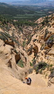
R1: 170' from a tree on Canyon Left. This starts low angle, then turns vertical in a narrow slot.
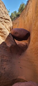
R2: 70' from a deadman, just above the 45' overhanging drop shortly downstream from R1.
A few downclimbs follow before the open streambed simply becomes the exit walk.
Exit[edit]
Walk the creek back to the shuttle car.
Drive: return on Diamond Mountain Rd, driving 18.5 miles back to Highway 40.
Red tape[edit]
Beta sites[edit]
Trip reports and media[edit]
Previously explored.
Jun2023: beta update, photos and map added


