Claustral Canyon
| Rating: | |||||||||||||||||||||||||||||||
|---|---|---|---|---|---|---|---|---|---|---|---|---|---|---|---|---|---|---|---|---|---|---|---|---|---|---|---|---|---|---|---|
|
| |||||||||||||||||||||||||||||||
| | Difficulty:3B III (v3a2 III) Raps:4-6, max ↨49ft
Red Tape:No permit required Shuttle:None Vehicle:Passenger Rock type:Sandstone | ||||||||||||||||||||||||||||||
| Start: | |||||||||||||||||||||||||||||||
| Parking: | |||||||||||||||||||||||||||||||
| Condition Reports: | 12 Apr 2026
"Claustral is one of the most iconic canyons in the Blue Mountains. The new bolts at the Keyhole abseil have altered some of the character that made th |
||||||||||||||||||||||||||||||
| Best season: | April, Sep;Oct;Nov;BEST in Dec - Mar
|
||||||||||||||||||||||||||||||
| Regions: | |||||||||||||||||||||||||||||||

Introduction
While not technically difficult (v3a2IV****) Claustral canyon’s sheer visual beauty makes it one of the best canyons in Australia and can be included amongst the best in the world. This impressive slot canyon features lush greenery covered canyon walls, waterfall abseils through a cave-like tunnel, swims, scrambles and even glow worms (if you reverse up Thunder canyon from the junction). Too good to rush. Take a camera.
Please check the National Parks website for notices and alerts:
Quality
- 4 star (international significance) quality in the FFME grading system
- 10/10 for quality and Medium difficulty in the OzUltimate/Brennan grading system
- Grade 4 (moderate to difficult) in Rick Jamison's Canyons Near Sydney guidebook
Water levels
- Catchments:
- ~2.5 km² at P4
- ~5 km² at Ranon
- ~10 km² at Thunder
- If you cross several smaller streams on entry (on the normally dry path, before the last ~300m wet gully to Claustral brook), P1 is starting to look like an easier jump or bottom of P4 is starting to look like a "harmless" but quite organised hydraulic, assume the P6 keyhole is now fully underwater (siphon) & dangerous
- There is almost no escaping the flow between the first abseil (very few, hard options), definitely not past P4 to the Thunder confluence (multiple past causalities in between).
- If water flow looks sustained near P4, send a more experienced party member or two to assess P6 before the entire party is committed.
- A BOM rain radar check over the last 24h can help to discover recent storm cells in the area.
- several parties have backed out of P6 due to underwater keyhole, in spite of all other weather sources suggesting a low-water day. 24h Radar suggested likely >30mm in the last 24h nearby (imprecise in BOM's current version, just a bunch of bad pixels around the area)
- There are no direct river gauges. The Grose river gauge at -33.615114, 150.629008 helps to determine recent rainfall and flows over a much larger area over the past few days. If you see something large that makes no sense, it can be useful to explain it (rule out Claustral)
Approach
- Download the GPX.
- From the roadside parking on Bells Line of Road, walk on the south side of the road in an easterly direction. Just before the start of the steel "Armco" crash barrier, find the constructed path running parallel to the road.
- The entry track from the road to the junction with Claustral Brook was upgraded in 2023 by NSW National Parks and Wildlife Service, and is now a well-graded walk-in.
Descent
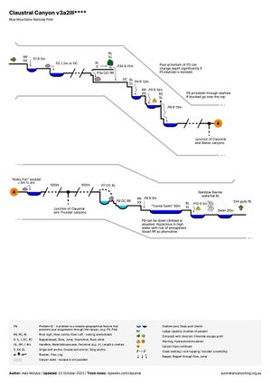
- The canyon topo is not to scale and only marks significant problems. It does not capture the finer nuances of the canyon.
- You are still required to possess good canyon route-finding skills to navigate the canyon
- Claustral is a long day for most parties with no straightforward escape after the P1 abseil.
- Claustral has had several canyoning fatalities in the past - do not underestimate the canyon.
| Problem number | Type | Metres | Location | Note |
|---|---|---|---|---|
| 1 | Abseil | 5m | RR | Unlinked bolts. Can be jumped but water level can vary. Check before jumping. |
| 2 | Jump / DC | 2m | RC | Jump or awkward down climb. Consider meat anchor + hand line for anyone not confident in jumping. |
| 3a | Down climb | RR | Down climb on river right. Requires dropping onto boulder from sitting position. Party members should support each other to descend safely. | |
| 3b | Abseil | 10m | RL | Approach along ledge on river left. Abseil from tree. |
| 4 | Abseil | 12m | RL | Chain-linked bolts. This pitch is the first of the "Black Hole of Calcutta" three pitch abseil series. Finishes in deep pool.
34m (SRT) just reaches bottom of P5 with rebelay at P5. |
| 5 | Abseil | 10m | RL | Chainset bolts. Single access bolt on canyon righ. Step up on the rock to find the access bolt and to easily reach the chains. Awkward narrow stance at anchor. Only enough room for about 3 people to stay out of the water. Small not too obvious ledge to unclip at the pool if needed. |
| 6 | Abseil | 15m | RL | "The keyhole": Chainset bolts, canyon left, on the downstream side of the keyhole. Access bolt through the keyhole on canyon right. Ledge at bottom to unclip on river right. The weight of the waterfall can be avoided by abseiling river right. |
| Creek walking / wading approx 500m | ||||
| Junction of Claustral and Thunder canyons. Thunder enters on river right. Thunder can be reversed as an optional side trip and adds approximately 30 minutes to 1 hour to the overall Claustral trip time. Thunder is well worth the effort due to glowworm cave at the end. | ||||
| 7 | Down climb | 5m | RL | Approximately 500m after the junction of Claustral and Thunder canyons there is a large ledge with overhang on river right. Avoid river right ledge and proceed by down climbing through boulder pile on river left. There are multiple routes through the boulders however the easiest most direct is on the very left. |
| 8 | Down climb | RR | From the P7 down climb proceed to river right to down climb | |
| 9 | Abseil | 5m | RR | Chain-linked bolts. High up on RR. Around a small corner so not visible upon approach. |
| Swim | 50m | The "Tunnel Swim" | ||
| 10 | Abseil | 4m | RR | Bolts on boulder RR, facing downstream.
Avoid old RL down climb with V crack (site of fatality in 2007, crack just wide enough to catch a human foot, hazardous in higher flow) |
| Shortly after P10 down climb/abseil Rainbow Ravine waterfall enters on river left. This indicates you are close to the exit. The exit gully is after a 20m swim found after the Rainbow Ravine waterfall. |
Topo
Alternate Topo:
Exit
- The exit gully (easy to miss!) is directly at the end of a 20m swim, after the entry of Rainbow Ravine waterfall into Claustral Brook on the river left
- The route proceeds up a steep gully for a short distance (~20m) and then traverses left (looking up the gully) under a cliff line. A metal arrow marker indicates the turn off left.
- Follow the footpath under the cliff until you're in Rainbow Ravine
- Proceeding up Rainbow Ravine requires several tricky rock scrambles that border on low grade unprotected climbs. You may wish to run hand lines and haul packs for less capable party members. Some may find the following two scrambles challenging:
- Dry boulder crack on the right when ascending. Good but hidden holds, may need to wedge a foot into a tight crack at the first step
- Wet boulder on the left when ascending. Get out of the water on a small wet ledge then traverse right via two carved footsteps, with good hand grips above
- Where the Rainbow Ravine gully splits higher up, head up the left branch.
- At the waterfall at the top (a couple of treated pine logs have been dug into the ground as steps), walk to the right along the ledge under a small cliff line to the other gully until you get near the creek, and then up a ramp to the left and back over the top to the left gully. Avoid using the pine log steps as above them it is eroded and slippery, and can easily be avoided via the newer walking route to the right.
As at 12/2025 three variant exits are in common use:
1) Via Camels Hump to Claustral Brook (longest route)
- Proceed up along a well trodden route to Camels Saddle. A metal arrow marker indicates the route direction (i.e. right).
- Proceed down onto the saddle and then turn left down a steep downhill until you reach Claustral Brook. A metal arrow marker indicates the route direction (i.e. left)
- Follow the the track along the Claustral Brook until you reach the junction with Dismal Dingle
- From here there are a couple of small canyon sections where you will get wet again - how much depends on your scrambling and bridging skills, and desire to (not) get wet.
- Proceed along Claustral Brook until you've reached the junction of the entry track and Claustral Brook. The entry track is also your exit track! Some have missed this in the past a proceed to accidentally descend Claustral Canyon again!
2) Abseil route (shorter route)
- Branches off the classic route at 33.5611° S 150.4086° E - the metal arrow marker near the Saddle. The arrow indicates right for variant 1. This route branches to the left instead.
- Requires one 20m abseil (or 2 x 10m abseils) from 2*bolts or look for slings.
- Finishes directly opposite the approach gully.
- This abseil route is a good 1h quicker than the above route descending Claustral Brook, avoids re-entering water, and brings you directly to the side-gully entry/exit track. Very well established as at 12/2025
3) Abseil route "short cut" (shortest route)
- Branches off the classic route at 33.5638° S, 150.4076° E and re-joins option 2 to reach the abseil route. Easy to follow as at 12/2025.
Red tape
- Claustral canyon is commercially run
- Due to its popularity the canyon will often have multiple parties in it on the weekend. Be respectful of other parties and if possible let faster parties pass
Beta sites
- OZultimate.com - Claustral Canyon
 Descente-Canyon.com : Claustral
 CanyonMag.net : Claustral Canyon
- NSW National Parks and Wildlife Service - Claustral Canyon
Trip reports and media
Background
Claustral Canyon was discovered by Sydney University Bush Walkers (SUBW) parties in the early 1960s but the waterfalls were first descended by a Kameruka Bushwalking Club party in 1963.