Clear Creek (San Juan Mountains)
| Rating: | |||||||||||||||||||||||||||||||
|---|---|---|---|---|---|---|---|---|---|---|---|---|---|---|---|---|---|---|---|---|---|---|---|---|---|---|---|---|---|---|---|
|
| |||||||||||||||||||||||||||||||
| | Raps:9, max ↨200ft
Red Tape:No permit required Shuttle:Required 30 min Vehicle:4WD - High Clearance | ||||||||||||||||||||||||||||||
| Location: | |||||||||||||||||||||||||||||||
| Condition Reports: | 19 Aug 2019
"Tons of logs across mid to lower clear creek drainage from avy debris. Pretty much impossible to get down top of middle down based on our observations |
||||||||||||||||||||||||||||||
| Best season: | Jul-Oct
|
||||||||||||||||||||||||||||||
| Regions: | |||||||||||||||||||||||||||||||
_Banner.jpg)
Introduction
An avalanche in Clear Creek during the 2018-2019 winter followed by the Ice Fire in October 2020 has rendered this descent not what it formerly was.
The Quality Star rating for this descent is unreliable as it may not reflect current post-avalanche and post-fire conditions.
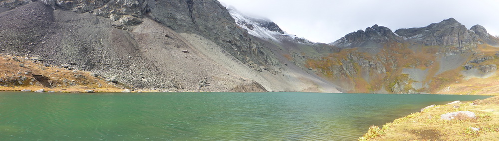
- Driving the 4x4 switchbacks to Clear Lake above the Upper Clear Creek waterfalls still provides unforgettable views.
- Middle Clear Creek was impacted by avalanche and fire.
- Lower Clear Creek was leveled.
- The Confluence of Ice Lake Creek and Clear Creek still has large avalanche debris at least 5 years later
Approach
For a full descent, set up a car shuttle. Leave a car at the bottom in the busy Ice Lake Trailhead Parking Lot. Drive up the dirt high clearance 4x4 switchbacks to Clear Lake.
Descent

Upper Clear Creek
This part of the canyon is open and slippery. The views are the best asset.
R1: 100'
R2: 100'
R3: 50'
R4: 45'
R5: 60'
_pic11.jpg)
Middle Clear Creek
This section had been the recommended section when it was free of debris and hidden in the forest. For a short day out, descending just Middle Clear Creek can be accomplished by parking at the switchback at the top, exiting at the bridge and walking the road uphill to the cars. The 4x4 switchback near the bridge is signed for No Parking.
Middle Clear Creek could be an option on a rainy day as the summer water flow and the commitment are both low.
_pic25.jpg)
_pic32.jpg)
R6: 120' (2022) Rappel into the corridor (was: rappel a full 200'/60m rope to a tree wiped out by the avalanche)
R7: downclimb through branch rubble (2022) (was: 140' from the tree mid-corridor around a bend in the stream course)
R8: 90' (2022) to the bridge (was: rappel 170' from above bridge to the bottom of the waterfall below the bridge)
_pic71.jpg)
_pic70.jpg)
_pic72b.jpg)
_pic73.jpg)
_pic74.jpg)
_pic75.jpg)
Lower Clear Creek
_pic51.jpg)
_pic52.jpg)
_pic53.jpg)
R9: unknown after avalanche (was: rappel 50' from tree in Canyon Center to the start of The Confluence)
_pic54.jpg)
_pic55b.jpg)
_pic56.jpg)
_pic57.jpg)
_pic58.jpg)
Confluence with Ice Lake Creek
The nature of the canyon changes with the rock band and the extra water from Ice Lake Creek. Re-assess the water volume in early season or after rains. Escape up the hillside canyon left if deemed too much. Otherwise complete the course to the road below.
_pic80.jpg)
_pic81.jpg)
_pic82.jpg)
_pic83.jpg)
Exit
Depending on the exit, hike switchbacks, the trail system, or the road back to vehicle.
Red tape
Beta sites
Trip reports and media
Background
2014-09-21 exploration descent. all natural anchors. Ira Lewis, AJ Pastula, Logan DeGrand, Leanne Thompson, Steven Arhart