Clouds Creek
| Rating: | |||||||||||||||||||||||||||||||
|---|---|---|---|---|---|---|---|---|---|---|---|---|---|---|---|---|---|---|---|---|---|---|---|---|---|---|---|---|---|---|---|
| | Difficulty:4B (v4a2) Raps:3, max ↨148ft
Red Tape:No permit required Shuttle:Optional Vehicle:4WD | ||||||||||||||||||||||||||||||
| Start: | |||||||||||||||||||||||||||||||
| Parking: | |||||||||||||||||||||||||||||||
| Condition Reports: | |||||||||||||||||||||||||||||||
| Best season: | Oct-Apr (avg for this region)
|
||||||||||||||||||||||||||||||
| Regions: | |||||||||||||||||||||||||||||||
Introduction[edit]
Good a3 flow with Clouds gauge on 60ML/d, when Orara gauge was too high on 790 ML/d.
https://waterinsights.waternsw.com.au/15324-richmond-regulated/river-data#204037
Approach[edit]
Enter the Clouds Creek State Forest at -30.03217, 152.65310 -30.03217, 152.65310. Drive as far as you can. Surveyors road now has a hard pack rock crossings on the creeks as of 05/2024. Waterfall and Old Pidcocks roads overgrown after fires. Waterfall is drivable but scratchy so recommended park when it becomes overgrown and walk along Waterfall Road and down to drop in at -30.040061, 152.678062 -30.040061, 152.678062. Note: The end of Waterfall rd is incorrectly marked on Google maps, it turns toward the canyon, not away from it. The correct coordinates are -30.0392612, 152.6769440
- Option 1 recommended: follow last gully on right just before end of Waterfall rd, down to R1 on large rock bar across creek at start of canyon.
- Option 2: continue to very end of Waterfall rd, find steep trail on right of spur to large rock platform above first pool. Cross creek up to R1 or scramble gully on left to water and start from R2.
Descent[edit]
| Rap | M | L/R | Description |
|---|---|---|---|
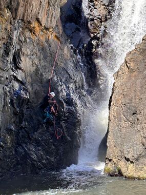
| DC | 10m | RR | From walking path with hand over hand rope at the end (Dec 2025) cross flow and downclimb into pool. |
| R1 | 20m | RC | 2 Glue-ins. Dry abseil into first large pool. Higher flow will create extra waterfall RR. Adding bolts on high point at RR would make a good first drop in high flow, 30m in the extra waterfall RR |
| Exit first pool RR. Follow ledge past narrow channel with small waterfall at end, submerged rocks, no anchor. Difficult scramble, or short rap off staples on ledge to start of second pool. Swim pool to R2 anchor RR. | |||
| R2 | 25m | RR | 2 Glue-ins near a corner at the top (can be waist high when you're standing there). Water funnels into a tight fissure - you can abseil down to a ledge about 3m above the boil then traverse away from flow - ledge eventually gives way to slippery sloping rock - good jump from here. Even in low water, last has to pull ropes from ledge and jump, otherwise friction makes rope pull extremely difficult. |
| R3 | 50m | RL | 2 Glue-ins far from edge. Into third large pool. Ledge at bottom. Better a longer rope to pull from other side of pool. |
| Quite a few 100m creek walk with optional small drops, scrambles and swims. | |||
| R4 | 50m | RR | 1 Glue-in. Swim across fourth massive pool. Better a longer rope to pull from other side of pool. |
Exit[edit]
Climb out and up to Old Pidcocks Road. Old Pidcocks does not go all the way to the creek anymore, as it's very overgrown. Once on the higher less step part it is easier to walk on the South side parallel to the old dirt road.
If tired of slippery swim/hopping on a rainy day there is an easy exit about 250m after R3 (still got about 500m to R4) at -30.03667, 152.67878 up ridge direct to cars
Red tape[edit]
Beta sites[edit]
Trip reports and media[edit]
 YouTube.com : ArdenE, Clouds Creek Canyon
