Conditions:Bear Creek-20240724010259
Latest: |
16 Jul 2024 (1 yr, 7 mos ago) |
|---|
| Reported by: | Smontanya (3 reports) | |
|---|---|---|
| Quality: | Ok |
|
| Waterflow: | Very High |
|
| Wetsuit: | ||
| Water temperature: | ||
| Difficulty: | Special challenges |
|
| Time: |
Team: 3 people with experience level Advanced to Intermediate
Trip report URL:
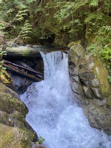
Comments: We did not run Bear Creek. Hiked up to the bottom of R4 and the top of R5. Water looked very high.We had no knowledge of what the flow would look like on the upper three raps or the condition of the anchors. It had not been run this year and there are too few reports to gauge what this flow would look like. We then chose to hike up Bear Creek to see R3 from the bottom. We fouond that there would have been no way to access the R3 anchor without an auto-belay or a protected traverse line and even the we couldnt know if anchors would be there if we could access it... Safety first. We ate lunch and hiked back out. We did look at bolt Creek River Rd Gage @ 2.08csf and Skykomish River Nr Gold bar @1460csf for reference. Definitely an August/Sept canyon. Pic for reference/ you can see this about about 1/2 mile up from the forest/creek edge before turning away from the water.
All condition reports
| Date | Quality | Waterflow | Wetsuit | Difficulty | Time | Team | Reported by |
|---|---|---|---|---|---|---|---|
| Good | Dry | | Normal | | 3 people | Jcsjcs (144 reports),Kristoffer (17 reports),Dfeerer (6 reports) | |
Comment: Note that the condition report below ours is from a different Bear Creek.
Hot approach up a well-maintained trail before traversing over to the drop-in. This canyon had a lot of fun downclimbs but not much in the way of rappelling. Anchors were in moderate condition; some webbing will need to be replaced soon. Excellent rock quality.
| |||||||
| Ok | Very High | | Special challenges | | 3 people Advanced to Intermediate | Smontanya (3 reports) | |
Comment: We did not run Bear Creek. Hiked up to the bottom of R4 and the top of R5. Water looked very high.We had no knowledge of what the flow would look like on the upper three raps or the condition of the anchors. It had not been run this year and there are too few reports to gauge what this flow would look like. We then chose to hike up Bear Creek to see R3 from the bottom.
We fouond that there would have been no way to access the R3 anchor without an auto-belay or a protected traverse line and even the we couldnt know if anchors would be there if we could access it... Safety first. We ate lunch and hiked back out. We did look at bolt Creek River Rd Gage @ 2.08csf and Skykomish River Nr Gold bar @1460csf for reference. Definitely an August/Sept canyon. Pic for reference/ you can see this about about 1/2 mile up from the forest/creek edge before turning away from the water. | |||||||
| Great | Dry | None | Special challenges | | 4 people Brand new to Advanced | Fish (3 reports) | |
Comment: We ran this canyon on our friend's birthday. It was his first conyoneering experience so we ran this canyone very slowly. We hiked in at night and camped in a nice sandy area with surrounding rock walls right where the return trail connects with the ascent trail.
Ascent from car to leaving the trail took 1.5 hours. Turn off trail at the ocotillo encircled with quarts. We were likely the only people to have ran this canyon in 2022 because between the second and third rappel there was a fully intact ram's carcass. We replaced webbing on all anchors (total 60 feet). First rappel's anchor was off a horn with chockstones and a good warmup height. The second rappel's anchor was off a large boulder on the right side. Recommendation to move far back when doing rope pull to avoid heavy abrasion on rope due to rough rock. Second rappel could have been accomplished with a 150 foot rappel to a wide ledge with a 30 foot down climb at the end, but we rappelled the whole 180 feet. The third rappel's anchor we rebuilt a cairn anchor as that appeared to be the only anchor option. This was a fun last rappel. Overall a very enjoyable trip with zero other human interaction close to Palm Springs and San Diego.
| |||||||
