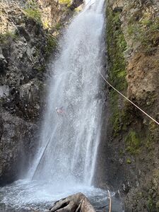
Conditions:Breitenbush River (South Fork North Fork)-KarlHelser@Facebook-2016-06-27
Jump to navigation
Jump to search
| Questionable: location? |
Data was extracted by automated processes and it may not be accurate. Confirm if correct, Edit to fix mistakes or Delete (permanent) if not relevant. (please login to edit report) |
|---|---|
Latest: |
27 Jun 2016 (9 yrs, 7 mos ago) |
| Reported by: | KarlHelser@Facebook (5 reports) | |
|---|---|---|
| Quality: | ||
| Waterflow: | ||
| Wetsuit: | ||
| Water temperature: | ||
| Difficulty: | ||
| Time: |
Trip report URL: https://facebook.com/groups/58689255788?view=permalink&id=10154300367635789
Comments: extracts from Facebook posts, click link for full details (privacy restrictions may apply)
- " Four of us descended South Fork North Fork Breitenbush last Monday (6/27). The approach and exit were straight forwad, but the water flow was HIGH! Thanks for the help from Thor Mac Cumhail and Luca Chiarabini, Deb Hill and I were able to stay alive." Pacific North-West Canyoning
All condition reports
| Date | Quality | Waterflow | Wetsuit | Difficulty | Time | Team | Reported by |
|---|---|---|---|---|---|---|---|
| Great | Moderate Low | Thin wetsuit | Advanced | | 4 people Expert to Intermediate | TexasLorenzo (38 reports) | |
Comment: Very wild and untouched canyon run. Removed several old and very unsatisfactory anchors. Ghosted most of it so if I remember correctly we only left anchors on 2 of the raps. One on a rock DCL of the rap in the cover photo and one on DCR tree of R2. Very tricky set ups, traverse lines, slippery rock, and dangerous log jams. The canyon itself is quite beautiful almost the entire way through but def not a trek I will ever do again. The road is open now, the hike in is not too bad but takes about an hr. The exit is a HUGE pain in the butt. The post fire damage has made the initial climb out very treacherous. We had to set up 3 hand lines for the 1st 500 feet of vertical. Very loose and crumbly dirt/rock. A fall here would be disastrous, possibly leading to a helo flight out. After reaching the top of that ridge you only have about 1300 more feet vertical to get over. IMO if you’re an advanced group and want to see something rare…it’s worth a go but be prepared to walk out in the dark and take plenty of H2O for that hike out! Def not a beginner friendly canyon.
| |||||||
| Great | Moderate Low | Full wetsuit | Special challenges | | 6 people Intermediate to Expert | Michelle (60 reports) | |
Comment: This canyon is like a smaller version of Big Creek in WA. The flow was mod-low, and the waterfalls presented no issues. R2 was intimidating for some people in the group, but as they rappelled they stayed mostly out of the water and had no issue. For R4 we went off the existing webbing and deadman, and were completely out of the flow, so for us R2 was the 'crux' rappel. On the exit, we followed the recently changed exit description in the beta from the group a few weeks before us, and were just about killed by falling rock and sliding down the extremely bad scree and loose dirt below the cliffs. Twice we had to lay down a rope and anchor on a tree for the rest of the group to batman up the rope and avoid dropping rocks below. Therefore I changed the beta back to the original beta that has a much safer exit through the vegetation just downstream of the talus field below the cliffs. Otherwise, the walking through the forest was very pleasant as there is no underbrush whatsoever, just some minor bushwacking right near the parking area.
| |||||||
| Great | Moderate High | Full wetsuit | Advanced | | 3 people Advanced | Blueshade (55 reports) | |
Comment: While not for beginners or those faint of heart, not really a problem for those experienced with high water. No hydraulics found and water was either endurable or avoidable depending on desires. Run at appx 146cfs. DCs at the end may require some above average skill.
| |||||||
| | | | | DaveSchroader@Facebook (1 reports) | |||
Comment: extracts from Facebook posts, click link for full details (privacy restrictions may apply)
| |||||||
| | | | | KarlHelser@Facebook (5 reports) | |||
Comment: extracts from Facebook posts, click link for full details (privacy restrictions may apply)
| |||||||
| Amazing | High | Full wetsuit | Advanced | | 4 people Expert to Advanced | Lucach (75 reports) | |
Comment: We encountered a lot more water than we expected. The canyon was extremely technical and every obstacle had to be carefully analyzed to find best solution. We had to rebuild all previous anchors and found no evidence of prior anchors anywhere in the canyon. We did find a watch and forgot a 200ft rope at the top of R3 rappel. If you find it please contact User:Lucach
| |||||||
| Significant | | | | 5 people | Jesseahouser (14 reports) | ||
Comment: Brian French, Jared Smith, Benjamin Trapanese, John Waller, Mike WIlliams
| |||||||
