Conditions:Fish Fork-20250220012741
Latest: |
2 Apr 2022 (3 yrs, 10 mos ago) |
|---|
| Reported by: | Willie92708 (1017 reports) | |
|---|---|---|
| Quality: | Amazing |
|
| Waterflow: | High |
|
| Wetsuit: | Full wetsuit |
|
| Water temperature: | ||
| Difficulty: | Advanced |
|
| Time:
"+" is not declared as a valid unit of measurement for this property. |
Team: 4 people
Trip report URL: https://www.facebook.com/groups/socalcanyoneering/posts/5232586470110356/
Comments:
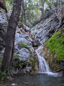
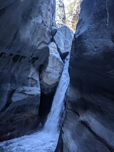
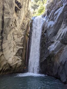
This is posted from my friend's report. His pictures look amazing, but read his report for the full story:
SoCal Roundup 2022...Fish Fork Trip Report
At some point in the weeks prior to the RoundUp Jayson had a bright idea to run Fish Fork with a Mt. Baldy summit approach. This sounded like a terrible idea, so a few of us immediately jumped on and started our planning.
Cesar had promised Carne Asada the night before we left which was basically the only thing the group was looking forward to. He started the grill late and by the time everyone was enjoying the meat (some more than others I'm told) we were already attempting to fall asleep and cursing the laughter and good spirits emanating from the campground.
We met Jayson at the trailhead at 3:00 am and started our ascent up the mountain.
Because we're awesome, we timed the summit to perfectly align with the sunrise.
I took some photos of the gorgeousness while Jayson made some snide remark about how I'm a terrible photographer for shooting his portrait into the morning sun. That photo has remained his profile picture until this day.
It had snowed in the days leading up to it so our original route was not a viable option, we decided on the now least threatening way down. Having enough of looking at Hell A from above we strapped on our microspikes and started our descent. A third of the way down we randomly ran into a kind, older woman who maybe weighed 90 pounds soaking wet. She was packing up her 100 pound pack and chatted us up a bit. She mentioned she found the body of Sri last spring after he presumably slipped and slid 2,000' down the mountain, exploding at terminal velocity on impact. She warned us to not make the same mistake, smiled, then walked her way back up the mountain as we continued down.
We found a steep but manageable descent route and I was out in front when I heard a bounce and a whoosh. Thinking quickly, I turned just as a rock smashed into the side of my pack. My team of gomers above couldn't have thrown this rock at me with that amount of velocity, so I took it as a sign that the canyon gods were warning us this was a stupid idea (or they just wanted my face to explode in the backcountry at a minimum).
Undeterred, we hit the canyon floor and started walking into the legendary Fish Fork. I say legendary because it's SoCal's highest rated canyon, but least travelled. Not because it's good.
If you're curious what Fish Fork is like, I'd like you to picture a 12 mile hike in the narrows, with full technical and overnight gear. Endless walking over slippery bowling balls, rappels every 3/4" mile, and a general feeling that the "technical" section is just around the corner, but alas it never comes.
What does come is nonstop creek walking, overgrown bush (reminiscent of Cesar Emilio Castro Torres’s mother), and a general MEH for the "canyon" itself.
It was brutally slow going and after 14 hours the group decided it was time to call it a day and set up camp at the Hotel California. It was cold now, so we quickly ate and then decided on spooning for our sleeping, starting with the largest man being held at the front to the smallest boy holding onto the group in the back. I quickly warmed up and nestled into Nathan's neck and placed my hands warmly between two pillows. In retrospect, I don't actually remember anyone bringing pillows, but I digress.
When the morning came we zipped up our wetsuits and started creek walking for miles upon miles.
It's worth noting there were a few rappels that were fun, at least for everyone but Jayson. The first big one had a pushy amount of flow and when Jayson came up out of the pool you could see deep within his eyes that he was thanking the white Jesus for sparing his soul.
There was another nice, 50' rap later on. I saw at the top, watching the team go down one by one. Jayson made some comment about being a Greek god one second before slipping on the rappel and smashing his beautiful face into the mossy wall. This was my personal highlight of the trip.
We eventually hit the confluence of the San Gabriel and pulled our gear off sensually, knowing now that the canyon was shite and the "fun" was over.
More and more arduous miles of creek walking came before we found ourselves at the bridge to nowhere. A few curious jumpers asked us if Brandon needed help because he was looking like death himself. We told them he desperately did, but not to worry, we weren't.
From that point on the creek walking subsided to more miles of trail walking, this time with the company of some lovely hikers who had turned up the noise on their boomboxes to a volume only matched by Jayson's now angry, pumping blood.
When we finally made it back to the escape pod the now broken Brandon asked us where we found our old man's strength. We replied in tandem that old men have a unique ability to hike endlessly since we have nothing left to look forward to at home; truer words have never been said. As we started the car and drove off the pain of the stupid idea quickly turned into laughter and fond memories of Brandon's consistent suffering.
In summary, Fish Fork is not a canyon for Canyoneers. It's a backpacking trip with some technical rappels. If that's your flavor, send it. If you prefer to have fun, I'd personally skip this but would for sure recommend it to my enemies.
I suspected it was a stupid idea, and I couldn't have been more right.
1 star, don't look at my photos and go "awww, it's gorgeous, we need to do it" or if you do, don't say I didn't warn you.— eating dinner with beloved family♥ with Nathan Elliott and
2 others
at FISH & FORK.
All condition reports
| Date | Quality | Waterflow | Wetsuit | Difficulty | Time | Team | Reported by |
|---|---|---|---|---|---|---|---|
| Amazing | Moderate | Thin wetsuit | Normal | | 4 people | Jcsjcs (141 reports),Kristoffer (17 reports) | |
Comment: Dropped off the shuttle vehicle at Heaton Flat. The road to Lupine was decent for a high-clearance vehicle. We camped for the night and were on the trail at 4:30 the next morning. Some of the fire roads on the approach were difficult to stay on in the dark but we made do with a bit of bushwhacking.
We dropped in at Little Fish Fork camp at 7:00 about half a mile upstream of where the beta indicates that the descent begins, as there did not appear to be a good path on the east side of the drainage. There were a few rappels in this upper section with existing anchors. The main portion of the descent had sections with a variety of characters such as flash flood debris, short slides, and long sections of creek walking. Fish Fork's technical challenges are largely concentrated in two groups about 1/3 and 2/3 of the way down the descent, characterized by the chockstone waterfall and the big waterfall respectively. The chockstone rappel had an intimidating amount of flow but ended up being easily doable by either swinging behind the waterfall at the bottom or keeping the rope DCR while on rappel. The big waterfall was a treat with some powerful flow at the bottom but no hydraulic challenges to speak of, as the water on the surface would easily carry one downcanyon. There were a few more miles of pretty creek walking after that before we arrived at the junction with East Fork at 14:15. After a break, it took two hours to get to the bridge and another two to complete the exit. All in all, Fish Fork was tremendously rewarding as well as challenging, and in our opinion deserves its mythical status in SoCal canyoneering lore. | |||||||
| Amazing | High | Full wetsuit | Advanced | | 4 people | Willie92708 (1017 reports) | |
Comment: This is posted from my friend's report. His pictures look amazing, but read his report for the full story:
at FISH & FORK.
| |||||||
| Amazing | Low | Thin wetsuit | Normal | | 2 people Beginner to Advanced | Stinky buds (7 reports) | |
Comment: Super gorgeous canyon. The approach was a bit longer than imagined. Came in from inspiration point..we kinda ditched the trail up at the ridge and just started shooting down into little fish fork camp which is where we camped at the first night. Our second day we shot straight into our canyon from little fish fork camp which was fun.. just a bit of bushwhacking and route finding but soon after you start hitting your rappels… all anchors are webbing… most are good except for two (the two bigger drops) needs to be replaced soon.. there was one rappel that we had to use a ghost anchor method on a tree due to no anchor...
side note one of the bigger drops(guessing 90-100 ft) has an anchor a bit far from the drop We only had a 70 meter rope so we extended our rope by tying in another rope to give additional length in order to retrieve rope after rappel.. so I would suggest bringing extra rope or anything longer than a 70 meter… The canyon had a great mix of jumps and slides with the rappels… once you get to fish fork camp area (fish fork meets San Gabriel river) you will no longer have rappels.this is where we slept for our final night before our exit.. It’s about 3 miles from fish fork to the bridge to nowhere and then 5 miles from the bridge to our second car.. with no special tasks or anything.. once you hit fish fork it’s basically just walking through.. such a beautiful peaceful canyon…
| |||||||
| Great | Moderate Low | Thin wetsuit | Normal | | 3 people Advanced | Mcc (20 reports) | |
Comment: This was a strenuous adventure surrounded by beautiful fall scenery. The handful of technical sections were really cool and pretty, but few and far between. Lots of creek walking. Most anchors were in decent condition. No special challenges. The flow was mellow and the water is cold. A thin wetsuit for those that get cold easily or a some kind of top is ideal.
We did the shuttle route from Guffy Camp (since the gate to Lupine Camp is closed for some reason. This adds an additional 3 miles to the approach, but it's all downhill) down to Heaton Flat. The long shuttle sucks but this way might be the least worst option. From Guffy to Fish Fork camp at the confluence with San Gabriel River took 10 hours. Then an easy hike out the next day. Take your time and enjoy this grand adventure. It's long and tiring but well worth it.
| |||||||
| Great | Significant | None | Special challenges | | 2 people Advanced | Fitbiker1031 (8 reports) | |
Comment: we started at inspiration point and hiked along the fire road from inspiration point to lupin campground. (9 miles) this took us 3 hours as we were traveling mostly at night hiking quickly. we slept for the night then started out at 6 am on a trail clearly marked fish fork. few turns and roughly 5 miles late, we dropped into fish fork at around 930 am. fish fork was a beautiful canyon, but a few setbacks. the canyon was much longer than we expected, (a guess of 8-9 miles) to reach the San gabriel river. it recently rained so the river was very muddy all the way down fish fork, which led to falling knee deep in mud pockets a couple dozen times. most of the time was spent doing fairly easy bouldering. expect a lot of just hiking in the canyon between repels. we finally reached San gabriel river at 730 pm. spent the night and started the hike up the San gabriel ( a lot of bouldering, easy, but alot) to join with the vincent gulch trail. all together our trip was about 30 miles. a very long hike no matter where u start from. fish fork was a beautiful canyon, just plan it being a little longer than u think.
| |||||||
| Amazing | Significant | None | Easy | | 1 people | AW~ (1 reports) | |
Comment: Travelling through elevations 6800 to 5800, aka the upper non-technical section, from Pine Mountain. Brisk water flow. Flash flood scars with large amount of gravel flooded the canyon....making for easy travel, but no pools or ponds. Hope some storms can clear it up.
| |||||||


