Conditions:Memaloose Creek-20170713004654
Latest: |
12 Jul 2017 (8 yrs, 6 mos ago) |
|---|
| Reported by: | Rockguac (3 reports) | |
|---|---|---|
| Quality: | Great |
|
| Waterflow: | Moderate High |
|
| Wetsuit: | Full wetsuit |
|
| Water temperature: | ||
| Difficulty: | Normal |
|
| Time: |
Team: 3 people with experience level Intermediate to Advanced
Trip report URL:
Comments: seasonal fires have changed the landscape dramatically, however the canyon runs the same.
All condition reports
| Date | Quality | Waterflow | Wetsuit | Difficulty | Time | Team | Reported by |
|---|---|---|---|---|---|---|---|
| Amazing | Moderate | Thin wetsuit | Normal | | Briwellman (89 reports) | ||
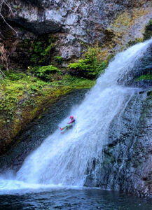
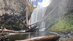
Comment: Great day to run the creek. The big logjam is still holding up at R1. When that releases, the creek will be a mess because its holding lots of logs. Highly recommended to climb behind R3 and slide. Super fun!
| |||||||
| Great | Moderate Low | Full wetsuit | Normal | | 3 people Advanced | Mads (61 reports) | |
Comment: This was a fantastic October canyon with quite nice flow for this time of year — better than we expected! We combined Memaloose and South Fork Clackamas in 4.5 hours car-to-car. We ran Memaloose first and it took us 2 hours from the car through R3. We found a rad slide on R3. Rappel 80 or so feet to the final ledge, then get off rappel and follow the ledge to the waterfall. 20’ slide straight through the flow. :) All anchors in good condition.
| |||||||
| Good | Moderate High | Thin wetsuit | Special challenges | | 3 people Beginner to Intermediate | PsychoWard (46 reports) | |
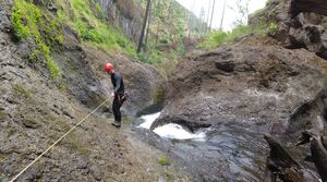
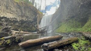
Comment: This short canyon packed a good punch for us. The log jam at R1 is extreme - It’s like a small city. We found a hole through it by climbing up and over and through the top on DCR, which allowed minimal interaction with the log jam. We replaced the webbing on R1, which is a log protruding out of the jam. We stayed out of the flow at first, but you’ll eventually end up in full flow toward the bottom. In retrospect, we probably should have put a wrap three on the log, but what we did worked well. The flow was pretty strong which made that rappel somewhat challenging. The R2 to R3 sequence was a little tricky and required a rebelay to R3 due to the flow level (about 60-65ft of rope). R3 is a great rappel line outside of the flow. The last rappel was pretty straightforward, it just required some awkward moving around some fallen logs. Overall a good day, but it was a bit more spicey than expected.
| |||||||
| Good | Moderate | Thin wetsuit | Special challenges | | 3 people Beginner to Intermediate | ClayShad (9 reports) | |
Comment: We dropped a shuttle car at the bend at Big Cliffs and then parked at Memaloose Bridge and walked up the 45 road. Took just over an hour and a half to walk up and then drop down the descent into the creek via the hand lines that are already on the trail down. The big log jam is still there above R1. It seems solid enough composed of very large logs. We threaded our way to the creek bed through the log jam from DCR. Replaced the webbing on R1. I consider this anchor marginal as it is only held onto the log by large protruding knot/broken limb. We backed it up with a meat anchor for the first two rappelers. More cautious canyoners may choose an anchor further back on the log jam, although the rope pull may be an issue then. R1 is a swimmer but you can stay mostly out of the flow until the last 10-15 feet where you will swing under the falls and into the main flow.
R3 was a challenge for our team as we didn't like not being able to see around the corner as the channel turns right in this three tiered whitewater drop. The water was really moving through this narrow channel. The second tier will sweep you off your feet and spin you around at this level but if you stay in control you can scoot onto the ledge DCL of that tier and regain your feet. R3 anchor is DCL at the bottom tier on the horizontal ledge. We opted to zip-line all our packs on this one. If the water is flowing hard or you have less experienced swift water rappelers you may consider setting up a rebelay from R2 to R3 to keep from getting washed over the falls at R3. Plan on a 50-60 foot rappel line. The logs at the bottom of R4 are mostly out of play. There was one strainer log we had to negotiate but when we rappelled the main line down to the bank, then stayed on rope until we could step onto the strainer log then come off rope and drop into the pool downstream of the log and swim, we were all fine. Walked the old trail out to the Clackamas and swam across. Clackamas was running at 950cfs at the Three Lynx gauge and the swim was pretty easy in the slack water. | |||||||
| Good | Moderate | Full wetsuit | Normal | | 3 people Advanced to Intermediate | Briwellman (89 reports) | |
Comment: We approached via the Memaloose Bridge and walked up the paved road. Followed the map, there is a trail leading all the way down to the creek complete with hand lines. There is a new logjam at R1 but all the rest of the log jams have been washed out. I think its a mystery where all those hundreds of logs go because they aren't in the creek. I'll update the beta.
| |||||||
| Good | Moderate | Thick wetsuit | Normal | | 5 people Brand new to Advanced | Fil (36 reports) | |
Comment: Hiked in from the convergence with Clackamas; crossed where the bridge used to be :( Fun raps with a fun belay from R1 to R2.
| |||||||
| Ok | Moderate Low | Full wetsuit | Special challenges | | 5 people Intermediate to Advanced | Briwellman (89 reports) | |
Comment: Approached bottom up. Crossed S Clack where the bridge used to be. Only a pipe remains. Lots of burned downed trees and sticker vines. Not a terrible approach. R1 was great!! The rest wasn't anything special. Water in memaloose is noticeably colder than S Clack. Exit back to S Clack was the same terrain as approach with downed trees and sticker vines add creek walking. Not terrible, not fun.
| |||||||
| Great | Moderate High | Full wetsuit | Normal | | 3 people Intermediate to Advanced | Rockguac (3 reports) | |
Comment: seasonal fires have changed the landscape dramatically, however the canyon runs the same.
| |||||||
| Unknown | Extreme | | | | Tiffanie (139 reports) | ||
Comment: Bridge crossing the Clackamas river and subsequent road is closed due to forest fire last year. We walked up the road about 1.5 miles and dropped into Memaloose. Water flow was way too high, we walked to the confluence and up S. Fork of the Clackamas but it was also running too high too. It ended up being an interesting hike.
| |||||||


