Conditions:Silver on the Side-20150310180546
Latest: |
7 Mar 2015 (10 yrs, 9 mos ago) |
|---|
| Reported by: | Bahman (11 reports) | |
|---|---|---|
| Quality: | Ok |
|
| Waterflow: | Dry |
|
| Wetsuit: | None |
|
| Water temperature: | ||
| Difficulty: | Normal |
|
| Time: |
Team: 2 people with experience level Intermediate to Advanced
Trip report URL:
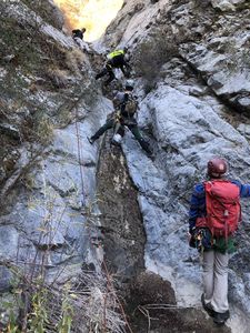
Comments: Lots of loose rock, particularly at the drop-in point, as well as some rock fall throughout the canyon. Lots of bushwhacking, throughout the canyon as well as at the exit. Anchor webbings (blue and purple in color) were mostly new, rigged by two climbers going through the canyon ahead of us.
All condition reports
| Date | Quality | Waterflow | Wetsuit | Difficulty | Time | Team | Reported by |
|---|---|---|---|---|---|---|---|
| Poor | Dry | None | Special challenges | | 6 people Brand new to Advanced | Eljefe62 (65 reports),Mikeatran (87 reports),Llamafilm (12 reports),Jleila (1 reports) | |
Comment: LOLOL SUCKFEST. Poison Oak and cuts and scratches and bruises oh my. Replaced all webbing/rebuilt all anchors.
| |||||||
| Unknown | | | Special challenges | | 3 people Intermediate to Expert | Exitfiftyone (22 reports),David (18 reports) | |
Comment: We attempted to approach Silver on the Side using the shortcut route. The first half of the route was brushy but easy enough to follow - the use trail kept us out of thick brush. The second half of the approach was a different story. Once we got to a flat lookout where the route "splits" (Suicide to the West, Silver on the Side to the East), we were able to easily identify the Suicide route, but not the SotS route. We spent a fair amount of time attempting to punch through thick brush to cut over to SotS, but didn't have much luck. Eventually we decided descending Suicide instead would make a better plan B.
So, if you're interested in descending SotS via the shortcut, be prepared for a heavy bushwhack. Some kind of tool (e.g. machete) would be highly recommended.
| |||||||
| Good | Very Low | None | Normal | | 4 people Intermediate to Expert | Rapbear (76 reports) | |
Comment: Took the short cut route. It's steep (~1500 ft in 1.8 miles) but in remarkably good shape. The guide ropes on the approach are showing their age.
Replaced many of the major rappel webbing as they haven't been renewed in quite some time and were often faded or crunchy. Rebuilt the R9 rock cairn anchor. Water flow is pretty non-existent except for the occasional pool. The canyon weed was trimmed back and the trail is easier to follow. Watch out for the poison oak. It's everywhere closer to the end.
| |||||||
| Great | Dry | None | Normal | | 5 people Advanced to Expert | Estunum (34 reports) | |
Comment: Anchors used were good, as we only did 5 or so rappels, down climbed the rest. This was a night run and the maintenance on the trail made this very easy on navigating. Updated the kml for the shortcut approach. Took us 5.5 hours car to car; Parking lot to sign at Suicide/SOTS fork, 1.25 hrs. Sign to bottom on SOTS, 1 hrs. Descent, 2.75 hrs. Exit, 0.5 hrs.
| |||||||
| Good | Dry | None | Normal | | 3 people Intermediate | ADubs (13 reports) | |
Comment: Canyon as described in beta. Used sneak approach. Handlines on the way up are still intact, though that nylon rope in the lower section of the climb has seen better days. We crossed the talus field as the brush was far too dense to try to combat, all the cleared trail remains in good shape. We used the bush at the top for R0 and did not try the ridge downclimb. We rebuilt the cairn anchor at the top of R9 and replaced the webbing because we didn't trust the tangle of what was there. We removed it, and replaced the corroded rapide as well. The rest of the webbing in the canyon is fine but the thin red webbing at the top of R8 will need replacing soon, I think. Poison oak is thick and everywhere after R6.
| |||||||
| Good | Very Low | None | Normal | | 5 people | Willie92708 (1015 reports) | |
Comment: Water flow has actually from basically zero to enough that the long trough downclimb required special stemming tricks to stay dry (see pic). I cheated and rappelled off a bush DCR on the rock face. Also, I verified that it's easy enough to proceed down the ridge from the drop-in rappel (off the ridge) and downclimb directly to lower section R1.
| |||||||
| Great | Very Low | None | Special challenges | | 2 people Intermediate | FChien (6 reports) | |
Comment: Completed using Suicide canyon approach in 5.5 hours car to car. 3.5 hours from drop in.
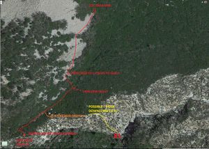
Followed the KML track to the shortcut drop in; the approach up until suicide canyon was great, After leaving the trail for suicide canyon to head towards the shortcut drop in, it turned to very dense brush. We navigated to a gully and followed that up. After a significant amount of bushingwacking, it appeared the gully was suddenly well cleared and the going go much easier all the way to the drop in. Big thanks to the team that did all the clearing!
| |||||||
| Good | Dry | None | Special challenges | | 6 people Intermediate to Expert | Willie92708 (1015 reports),Cesar (21 reports) | |
Comment: We started on the same approach as suicide with a total elevation gain of about 1,500. The 6 of us did a lot of work on the approach clearing a path most of the way up to the first rappel on the side of the canyon. If you take this approach beware (as shown in attached image) that as you exit onto the rock section (scree and talus) and start climbing up there is a risk of being hit by rocks. As I was going up this section, I came close to a large rock (about half my size) and it with the entire section of smaller rocks started to slide down the mountain only to stop about 2 ft down. This was not a fun experience and the reason that next time I would cross at the lower section instead of going high. The canyon is fun and the anchors are good. We replaced and place new webbing where needed. At some of the rappels it may be a good idea to keep your eyes open for rocks that are ready to fall and just kick them down (as long as there is no one below you). After the last rappel, you still have a couple of down climbs that may require a hand line and your butt protector. Over all good time and next time we run the canyon it will be on less time. We also placed a few cairns where necessary to help with the approach navigation in the rock band. Willie: you follow the Suicide approach to a junction at 34.27409, -118.22384 and head straight North (not West to Suicide) to gain the talus field directly. Also: there is now 2 anchors to rappel into the canyon, but we noticed that there is also a low angle sub-ridge that goes directly down to R1, so it may be possible to enter the canyon without rappelling into it.
| |||||||
| Good | Dry | None | Special challenges | | 2 people | Willie92708 (1015 reports) | |
Comment: We did enough work to finish the trail to the scree / talus field, then cut our way into the small gully. We headed up the gully further than the entry waypoint, because the travel was easy, and we soon could see the ridge on the side. We rappelled 130 feet into the canyon floor by a sizeable tree. We did not do any trimming in the canyon, which was mostly OK, except for sticker vines below the downclimb (was a rappel) that is clogged with dead trees. We replaced all the webbing on all anchors (except one set of bolts) and rebuilt the cairn anchor for the last rappel (180 footer)
| |||||||
| Poor | Very Low | None | Special challenges | | 2 people Advanced | Tarannosaurus (26 reports) | |
Comment: Used the Stone Canyon approach for extra conditioning. I think this canyon should be re-named Booby Trap. The rock was incredibly deceptive, particularly in the upper portion of the canyon, making down climbing extremely difficult since seemingly solid foot and hand holds would regularly pull out of the rock (this was also true if you were hiking anywhere near the edge of the watercourse - the ground would crumble beneath your feet). Trees and bushes were hardly more trustworthy, with so many of them being dead and brittle. Replaced several anchors and webbing, including the webbing at the top of the 120 foot rappel which literally tore in half when we tested it. There were no good anchor sources readily available at the 180 foot rappel, so we built a cairn anchor in a little pothole in the water course - the next group to come through will be greeted with rotting webbing and a rusted link (sorry). Also very brushy in several portions of the descent - lots of thorns and scratches today. Overall a major slog for only a couple of attractive sections. Would certainly benefit from a clean up (we didn't have time for much since we exited in the dark anyway), but nothing is going to fix the loose/falling rock issue. Recommend using the shortcut approach since the rock quality seemed to improve over the descent.
| |||||||
| Ok | Dry | None | Normal | | 2 people Intermediate to Advanced | Bahman (11 reports) | |
Comment: Lots of loose rock, particularly at the drop-in point, as well as some rock fall throughout the canyon. Lots of bushwhacking, throughout the canyon as well as at the exit. Anchor webbings (blue and purple in color) were mostly new, rigged by two climbers going through the canyon ahead of us.
| |||||||


