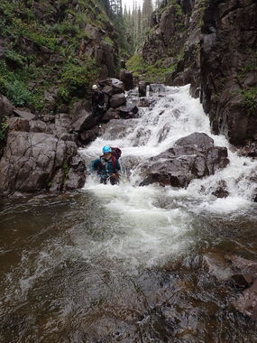
Conejos River (North Fork)
| Rating: | |||||||||||||||||||||||||||||||
|---|---|---|---|---|---|---|---|---|---|---|---|---|---|---|---|---|---|---|---|---|---|---|---|---|---|---|---|---|---|---|---|
| | Raps:0
Red Tape:No permit required Shuttle:None Vehicle:Passenger | ||||||||||||||||||||||||||||||
| Location: | |||||||||||||||||||||||||||||||
| Condition Reports: | |||||||||||||||||||||||||||||||
| Best season: | Jul-Sep
|
||||||||||||||||||||||||||||||
| Regions: | |||||||||||||||||||||||||||||||
Introduction[edit]
This is pretty section of narrows with quite a bit of water, but is non-technical and only yields a handful of slides in the canyon. The primary reason for posting is to make sure no one else wastes their time hiking up there to explore the canyon if they are looking for a technical canyon.
Approach[edit]
Drive to Three Forks TH west of the seasonal town of Platoro, CO. From Platoro drive west/north on County Road 250 for 5 miles then left onto Forest Road 247 for 5 miles and park at the end of Fdr-247. Starting elevation is 10,200 feet. Follow the Conejos River Trail past a sign for South San Juan Forest for about 2 miles to a sign for Three Forks, stay straight on Trail #712 for about 1/4 mile to a fork; take the right fork (north) Trail #714. The trail will switchback steeply through the forest for about a half mile. Once the trail flattens and you can start to glimpse the river, leave the trail to start your descent.
Descent[edit]
Several slides leading into chest deep boils.
Exit[edit]
Once the watercourse flattens out and before the confluence with the Main Fork Conejos River, exit left to find the trail you came in on.
Red tape[edit]
Beta sites[edit]
Trip reports and media[edit]
First descent 9/5/15 Kelton Manzanares, Logan DeGrand, and Stephanie Minnaert https://www.facebook.com/media/set/?set=a.1470292059966128&type=1&l=63ccba4d4f
