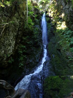
Cora Creek
| Rating: | |||||||||||||||||||||||||||||||
|---|---|---|---|---|---|---|---|---|---|---|---|---|---|---|---|---|---|---|---|---|---|---|---|---|---|---|---|---|---|---|---|
| | Raps:5-6, max ↨95ft
Red Tape:No permit required Shuttle:None Vehicle:Passenger | ||||||||||||||||||||||||||||||
| Start: | |||||||||||||||||||||||||||||||
| Parking: | |||||||||||||||||||||||||||||||
| Condition Reports: | 23 Jul 2023
"No anchors were found, so possible first descent. Easy shortie creek; nothing too remarkable. R2 is the real reason to run this one where the creek pl |
||||||||||||||||||||||||||||||
| Best season: | May-Jul
|
||||||||||||||||||||||||||||||
| Regions: | |||||||||||||||||||||||||||||||
Introduction[edit]
A pleasant, mostly mellow shortie creek draining Cora Lake north of the Sawtooth Ridge in Gifford Pinchot National Forest. It's actual name is "Big Creek", but I'm labeling it Cora Creek here to avoid confusion with the more famous Big Creek further south. Cora Creek is short & sweet (can be run in a few hours); it's probably not a great destination unto itself, but could be combined with other canyon adventures in the neighborhood, or if you want something short on a rest day. Would rate it as entirely beginner-friendly (with the exception of R2, which could be skipped).
- Checkpoint: Check the flow where Cora Creek flows under the road just before parking area.
- Watershed: 0.8mi^2. Highest point in watershed is about 5400ft. The watershed is north-facing and may hold snow later in the season.
Approach[edit]
From the Cora Lake trailhead, follow the trail upward about 0.45mi. The trail crosses below R2, then switchbacks up and crosses again just before R1. Just before the second creek crossing, bushwhack upwards (easy) to the top of R1. There's a nice bench above the creek for suiting up. You might take a quick detour over to the lake for great views of High Rock towering above.
Descent[edit]
DCL = Down Canyon Left; DCR = Down Canyon Right.
This is a high tourist area. Please do not leave fixed anchors in places visible from the trail.
- R1: Two-tier 95ft onto the trail.
- R2: Cora Falls- 90ft from a tree DCL down a 4ft wide slot reminiscent of Apparition Falls on Olallie Creek. This is the crux rappel and could be dangerous in high water. (See the signature photo above.) Beware a large vertical log right in the middle of the chute which might be prone to catching ropes during the pull. If the flow permits, it might be better to break this up into two stages:
- R2a: 55ft to a small platform big enough for 1-2 people at the base of the log.
- R2b: 30ft from an anchor on the bottom of the log out of the slot.
Climb over a large logjam at the bottom (slight user trail DCL) to reach the trail crossing. There's another 20ft two-stage drop below the trail, but it may not be worth your time due to a lack of good anchors. Bypass DCR.
- R3: 35ft. Huge old growth log spanning the creek below the falls.
- R4: 20ft from log creek center.
There's a short walk to the next falls; can by pass some of the brush by jumping out of the creek briefly DCL.
- R5: 45ft from tree DCL. Beware healthy grove of devils club atop the falls.
Exit[edit]
Below R6 is a garden of Devil's Club. It's probably best to exit the creek and bushwhack back to the parking area (5min) in largely open forest.
Red tape[edit]
None.
Beta sites[edit]
Trip reports and media[edit]
Background[edit]
First descended in 2023.
