Cornet Creek
| Rating: | |||||||||||||||||||||||||||||||
|---|---|---|---|---|---|---|---|---|---|---|---|---|---|---|---|---|---|---|---|---|---|---|---|---|---|---|---|---|---|---|---|
| | Raps:3, max ↨150ft
Red Tape:No permit required Shuttle:None Vehicle:Passenger Rock type:sandstone | ||||||||||||||||||||||||||||||
| Location: | |||||||||||||||||||||||||||||||
| Condition Reports: | |||||||||||||||||||||||||||||||
| Best season: | Jun-Sept
|
||||||||||||||||||||||||||||||
| Regions: | |||||||||||||||||||||||||||||||
Introduction[edit]
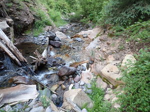
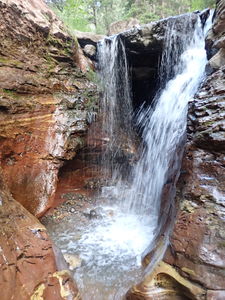
The bottom of Cornet Falls is a short hike from downtown Telluride. The approach gives amazing views of Telluride and the box canyon of the San Miguel River. The main attraction is Cornet Falls, but two short drops upstream make this feel like more of a canyoning route.
This waterfall is a confirmed nesting site for the Black Swift, listed as a Species of Special Concern by the U.S. Forest Service and U.S. Fish and Wildlife Service. The swifts migrate from Brazil annually to occupy this site from late May until late September, raising a single chick. The swifts are susceptible to disturbance from human activities near their nests, including noise and movement, direct disturbance or destruction of their nests, and trampling of vegetation. Canyoneering/climbing at this waterfall during the Black Swift nesting season (late May - late September/first frost) is likely to cause direct damage to nests, eggs, and young, and disturb adult swifts enough to cause them to abandon their nest and offspring. Click here for more information on the Black Swift.
Approach[edit]
Park on North Aspen St near the corner of W Dakota Ave.
The Jud Wiebe Memorial Trail forms a loop, crossing Cornet Creek on a bridge. Hike either way.
* Option 1 Counterclockwise: Walk one block south on N Aspen St, go left (east) one block on W Galena Ave, head left (north) on N Oak St and turn right (west) on Tomboy Rd, just past W Gregory Ave. Hike the one car wide dirt Tomboy Rd for a quarter mile and turn left (northwest) on Liberty Bell Rd at a trailhead sign. Continue uphill past giant water tanks and onto the Jud Wiebe Memorial Trail. Continue to the bridge over Cornet Creek.
Approach: 1.4 miles, +863'
* Option 2 Clockwise: From the parking on North Aspen St, continue north on North Aspen St past the sign indicating this is a Dead End. The Jud Wiebe Memorial Trail starts just past the end of the road. Go left (west) over the bridge to start uphill. While longer, this direction is verified to provide stunning views of the town and valley. At a trail junction with the Mill Creek Waterline Trail, stay right. Continue to the bridge over Cornet Creek.
Approach: 1.9 miles, +1140'
Descent[edit]
At the bridge over Cornet Creek, begin downstream.
R1: 25' from a slung bush in Canyon Center. Short, but slippery
R2: 20' releasable from a tree on Canyon Right
R3: 150' Cornet Falls from a higher tree set back on Canyon Left. 30' of webbing was tied in a loop. This location made for an easy pull from below and easy to get on rope. The final 100' of the rappel is free-hanging.
Exit[edit]
Walk a quarter mile back to the car on an obvious trail. As of 2022, some trail damage has occurred with fallen rocks/slide, but it picks right up again.
Red tape[edit]
Beta sites[edit]
Trip reports and media[edit]
2022-06-25 Known to not be the first descent. Page created, info, photos and map added by Ira Lewis and Ryan Humphries


