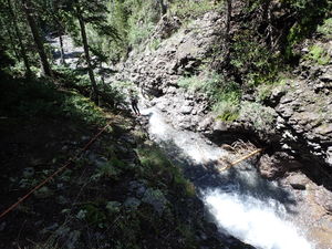
Cub Creek
| Rating: | |||||||||||||||||||||||||||||||
|---|---|---|---|---|---|---|---|---|---|---|---|---|---|---|---|---|---|---|---|---|---|---|---|---|---|---|---|---|---|---|---|
| | Raps:3, max ↨100ft
Red Tape:No permit required Shuttle:None Vehicle:Passenger Rock type:Conglomerate, Sandstone | ||||||||||||||||||||||||||||||
| Start: | |||||||||||||||||||||||||||||||
| Parking: | |||||||||||||||||||||||||||||||
| Condition Reports: | |||||||||||||||||||||||||||||||
| Best season: | Jun-Sep, BEST Aug-Sep
|
||||||||||||||||||||||||||||||
| Regions: | |||||||||||||||||||||||||||||||
Introduction[edit]
Cub Creek is a great intro canyon with nice rappels and would likely be descended as much as Lower Angel Creek if it weren't such a long hike up the Bear Creek Trail and up a steep final meadow. It's certainly worth descending once.
Combine with Bear Creek if afternoon thunderstorms are NOT in the forecast and the team can move quickly through the overall distance and elevation gain.
Approach[edit]
Cub Creek is a tributary of Bear Creek and located upstream of the Bear Creek technical descent.
Hike the Bear Creek Trail (241) from the dirt parking lot on the East side of Hwy 550 by the tunnel for 2.8 miles and cross Cub Creek. Continue a short distance on trail until a large steep meadow on the left side of the trail.
Hike up the meadow (+350'). At the top find a game trail at the edge of the forest on the left and follow this as it contours trending downhill to intersect Cub Creek.
Descent[edit]
R1: 80' for 40' falls from a rock pinch in Canyon Center
R2: 60' from a rock pinch on Canyon Right
R3: 100' from a tree on Canyon Left for a two stage rappel
Exit[edit]
After the final rappel, hike a short distance to the main Bear Creek Trail and return to the parking lot below. Add in a descent of Bear Creek on the way if afternoon thunderstorms are NOT in the forecast and the team can move quickly through the overall distance and elevation gain.
Red tape[edit]
Beta sites[edit]
 Super Amazing Map : Cub Creek
Trip reports and media[edit]
First known descent by Logan DeGrand and Tom Collins III. July 2016
27Aug2022: kml map and beta details added. Ira Lewis, Dan Kinler, Ryan Humphries


