Cunningham Creek
| Rating: | |||||||||||||||||||||||||||||||
|---|---|---|---|---|---|---|---|---|---|---|---|---|---|---|---|---|---|---|---|---|---|---|---|---|---|---|---|---|---|---|---|
| | Raps:2, max ↨50ft
Red Tape:No permit required Shuttle:None Vehicle:High Clearance | ||||||||||||||||||||||||||||||
| Start: | |||||||||||||||||||||||||||||||
| Parking: | |||||||||||||||||||||||||||||||
| Condition Reports: | 16 Aug 2022
"Excellent flow. Replaced webbing and rapides at both rappels. It was a fairly cold, overcast morning. I wore a 4/3 with a 3mm neoprene vest and was co |
||||||||||||||||||||||||||||||
| Best season: | Jul-Oct; BEST Aug-Sep
|
||||||||||||||||||||||||||||||
| Regions: | |||||||||||||||||||||||||||||||
Introduction[edit]
A few very nice aquatic waterfalls with a quick approach and exit. The surrounding valley is quite pretty and the two rappels are of good quality so some may find the route worthwhile. If only the technical portion was longer…
Later in the season, this may be a nice spot to take someone new to the sport for a more aquatic canyon experience.
Cunningham Creek could be descended along with nearby Mountaineer Creek (http://ropewiki.com/Mountaineer_Creek).
Approach[edit]
Drive: from W 12th and Greene St in Silverton, drive 4.4 miles East out of town on CR 2. Turn South at Howardsville on CR4 for another 4.5 miles and turn Left at the fork to the Highland Mary Lake Trailhead.
Hike up the trail for a quarter mile noting smaller cascades in Cunningham Creek on the right. Once above an obvious cut through a cliff band, depart the trail and approach the creek.
Descent[edit]
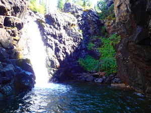
R1: 50’ from a tree on Canyon Left. Can be done inside or outside of the flow. Lands in a shallow pool below.
R2: 30' from a rock horn / pinch Canyon Right into a narrow pour spout and a neat alcove with a waist depth pool. You will be directly in the waterflow on this rappel and in higher flow pummeled by a rooster tail.
After R2, leave the alcove by downclimbing a small fall and continue downstream until it's easier to regain the trail.
Exit[edit]
Follow the trail downhill to the car.
Red tape[edit]
Beta sites[edit]
Trip reports and media[edit]
Explored 28Aug2020. Ira Lewis, Chris D'Amico


