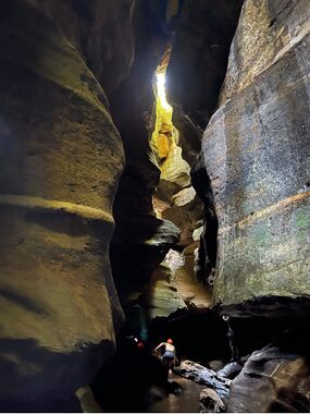
Dargans Creek
| Rating: | |||||||||||||||||||||||||||||||
|---|---|---|---|---|---|---|---|---|---|---|---|---|---|---|---|---|---|---|---|---|---|---|---|---|---|---|---|---|---|---|---|
| | Difficulty:2A (v1a1) Raps:0
Red Tape:No permit required Shuttle:None Vehicle:High Clearance Rock type:Sandstone | ||||||||||||||||||||||||||||||
| Location: | |||||||||||||||||||||||||||||||
| Condition Reports: | |||||||||||||||||||||||||||||||
| Best season: | Oct-Apr (avg for this region)
|
||||||||||||||||||||||||||||||
| Regions: | |||||||||||||||||||||||||||||||
Introduction[edit]
Dargan creek canyon is a short, easier but still very pretty canyon downstream of the Railway dams at Clarence. The dams are a popular swimming and climbing spot and the car park can fill up quickly on a summer weekend.
Rope: 10m handline handy
Wetsuit: recommended
Walk in: 20-40min
Walk out: 20-40min
Descent: <1hour
Elevation Gain: 180m
Distance 3 Km
Approach[edit]
Car Park: Turn off of Bells Line of Road just west of a railway bridge at MGA436929 and follow the access road beside the railway. Turn left before the locked gate then right and follow through to the car park. This road can get rough so 4wd handy for clearance.
Walk-in: From car park walk down the hill towards the dam. Before the dam wall go right over a sandstone ledge then down to the left following the climbers access trail. Cross creek and past main wall then cross back over near the foundations for old pump house. Then up to the cliff base on river right and work your way downstream.
Note: since the 2013 fires this section is very scrubby. An alternate route is to head along a fire trail from the car park on a spur that traverses the top of the lower climbing area, At the end of the climbing area scramble down through the cliff with aid of a handline.
Once around a big righthand bend suit up and enter the creek at MGA4459145
Canyon starts fairly open with a couple of small down climbs before it closes in for a nice dark constricted section.
It's also possible to rap in close to the canyon start with a 30m abseil from a tree at the cliff line below the fire trail uswed to exit along te ridge
Descent[edit]
Exit[edit]
Option 1[edit]
Reverse back up canyon and out the way you came in
Option 2[edit]
From where the canyon opens back out use a fixed-line to scale the waterfall coming in on the right. Then up the next cliff by using spikes in the tree which were apparently in place before the mid 50s. From there work up the side creek, the first part is exposed and aided by a fixed-line. then scramble up to the right to access the end of a fire trail leading back to car park.
Option 3[edit]
With prior permission of landowner at the bottom, it is possible to drop a car in Hartley vale and do a through trip. Flynny's tip: Don't ever do this.!You know how much I love a scrub bash but seriously not worth it.
Red tape[edit]
https://www.darganscreekreserve.org.au/
Beta sites[edit]
Trip reports and media[edit]
 Wikiloc.com : Dargan's Canyon
https://sleepwhenwearedead.net/2018/02/10/dargan-creek-photo-trip/
