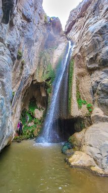
Darwin Falls
| Rating: | |||||||||||||||||||||||||||||||
|---|---|---|---|---|---|---|---|---|---|---|---|---|---|---|---|---|---|---|---|---|---|---|---|---|---|---|---|---|---|---|---|
| | Difficulty:3B II (v3a2 II) Raps:3, max ↨110ft
Red Tape:No permit required Shuttle:Optional 0 min Vehicle:4WD | ||||||||||||||||||||||||||||||
| Location: | |||||||||||||||||||||||||||||||
| Condition Reports: | 28 Oct 2023
"Road to Darwin Falls is almost completely gone. Access is closed to the public except via walk in. Canyon was once again scoured by the Aug Hurricane |
||||||||||||||||||||||||||||||
| Best season: | Nov-Mar (avg for this region)
|
||||||||||||||||||||||||||||||
| Regions: | |||||||||||||||||||||||||||||||
Introduction[edit]
Warning: the road is closed and it is not legal to drive in the wash. Be prepared to hike from CA-190.
Amazing waterfall rappel, attentive shrubbery and some fun bypasses after the first rappel-er lands. The first (larger) waterfall sequence is private, but the second (smaller) waterfall is a popular hiking destination and the chances of an audience are often high.
Darwin Falls Canyon changed a lot in 2022 and 2023. Major flood in August 2022 scoured away vegetation. Then a storm in January 2023 filled the pools in with gravel (ankle deep water!). The remnants of Hurricane Hilary flooded the area in August 2023, removing what little vegetation remained and damaging Panamint Springs Resort's waterline. That storm also destroyed the gravel road.
Approach[edit]
You can't drive to the parking area anymore due to flood damage. You have to park on shoulder of CA-190, and hike 2 or 3 miles to the parking lot. From parking area. Head up the road until there is a fork. Take the right branch.
After a few tens of feet, there will be an obvious use trail going up to the ridge on the right. This continues upward before changing from dirt to more stoney outcroppings. Cross a saddle (the summit of the approach) and continue following the obvious trail as it descends toward the canyon in roughly the same direction.
Link title==Descent== In canyon proper it can be hard to find any trail through the brush (if one even exists). The brush is 10 ft tall reeds, trees/branches and a stream at your feet that can be unexpectedly soggy. It might be more fun to simply avoid these sections by going around on the right, but that isn't as much of a canyon descent is it? ;)
The first waypoint of note is at the first small waterfall (not the first rappel) where cairns lead off to the right along the ridge. This cairn ridge is not the route, it seemed to be an escape route that never re-joined the canyon. The real route requires crossing the stream to get on the left side.
Then comes the whole shebang! A lush, green waterfall drops 100+ ft into a pool of water, and then two more stages follow. The rappel is to the waterfall's down-canyon-right from a small chockstone and its the perfect distance for a fun overhung rappel along side but not splashing in it.
First Rappel: Slung Chockstone (100 or 200 ft)
Lands into a hidden alcove that is hard to see from the top. Requires at least first person to swing or swim to the left across the waterfall. They can then bring each person in to them by the first reeling the rope into their rock after rappel. Be very careful to minimize damage to moss while descending gently. After the first drop (just under 100 feet), there are two additional stages that can be descended with a single 200ft rope. The pull is fairly easy and direct, though the best spot to pull is slightly more than 200ft from the anchor. Alternatively, there is a rock chock anchor to descend the second phase. The second phase can also be bypassed on canyon left.
Continue down canyon along a clear use trail.
Second Rappel: Large tree (40 ft)
Until fall 2023, this was anchored from a large tree. That tree is no longer standing. There are variety of anchor options.
The base of this waterfall is a popular hiking destination, so you are likely to have an audience. Make sure to represent the canyoneering community well.
Exit[edit]
After second rappel, greet the casual hikers and walk the flat river bed back to the car.
Red tape[edit]
A Death Valley National Park permit is required for vehicles in this area.
Beta sites[edit]
- Nov. 2022 Descent
 BluuGnome.com : Darwin Falls Canyon
 Chris Brennen's Adventure Hikes (Southwest) : Darwin Falls
 ToddsHikingGuide.com : Darwin Falls
- https://www.stavislost.com/hikes/trail/darwin-falls
