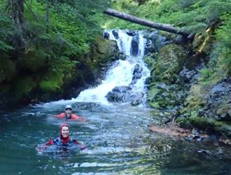
Deadhorse Creek
| Rating: | |||||||||||||||||||||||||||||||
|---|---|---|---|---|---|---|---|---|---|---|---|---|---|---|---|---|---|---|---|---|---|---|---|---|---|---|---|---|---|---|---|
| | Raps:9-12, max ↨150ft
Red Tape:No permit required Shuttle:Required 15 min Vehicle:Passenger Rock type:Andesite, Basalt | ||||||||||||||||||||||||||||||
| Start: | |||||||||||||||||||||||||||||||
| Parking: | |||||||||||||||||||||||||||||||
| Shuttle: | |||||||||||||||||||||||||||||||
| Condition Reports: | 30 Aug 2025
"Incredible day featuring the best rappels I done here in the PNW! Def not a canyon for anyone uncomfortable with being in heavy flow! Sharp edges, sli |
||||||||||||||||||||||||||||||
| Best season: | Aug-Sep
|
||||||||||||||||||||||||||||||
| Regions: | |||||||||||||||||||||||||||||||
Introduction[edit]
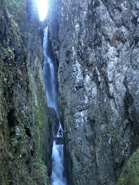
Deadhorse Creek is located within Mount Baker-Snoqualmie National Forest in Whatcom County, Washington. It is a tributary of Wells Creek and the North Fork Nooksack River. Deadhorse Creek forms the drainage basin between Cougar Divide and Skyline Divide. It is sourced primarily from semi-permanent ice (Hadley Glacier) and snowmelt. Deadhorse Creek is remarkable in that it includes a tall, narrow crack in addition to canyon development typical of the region. The technical challenges of this stream include its committing nature, high flow, and big, narrow pitches.
Special note for season openers and anchor maintainers[edit]
It is recommended that the first group of the season be prepared to install sustainable anchors (unlinked 316 stainless steel bolt anchors or v-threads) in the event that the existing bolt anchors are damaged. Safe natural anchor options are extremely limited at the bolted pitch heads. Also be prepared to replace webbing and quick links on the natural anchors.
Waterflow[edit]
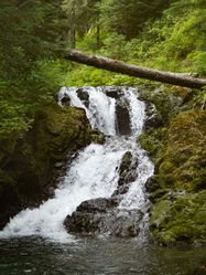
Despite the roar and ominous appearance at the top of the three big pitches, the flow is dispersed such that the descending canyoner does not necessarily experience the full force of the water. Beginners will likely be intimidated and have difficulty. Advanced canyoners experienced with swift water may be able to safely negotiate more flow than in the “Very High” reference photo. Once in the deep chasm of this canyon, the wind and spray can make it very cold, so it is advisable to avoid unnecessary immersion until after you have progressed below the final big pitch. As of 2021, there were no unavoidable hydraulics.
Checkpoint (bridge)[edit]
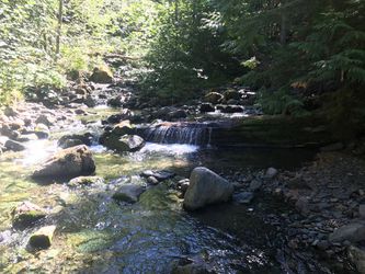
The checkpoint photo just upstream of the bridge is not indicative of the actual flow in the canyon because several hundred feet upstream of the bridge checkpoint, Deadhorse Creek bifurcates, with part of the flow going north to the North Fork Nooksack River, and part going east into Wells Creek. This is not indicated on most maps but is shown on the Ropewiki map. Anticipate the flow in the canyon to be approximately 3-4 times that of the flow at the bridge checkpoint, since the majority of the flow is diverted away from the bridge.
Checkpoint (waterfall)[edit]
Once at the drop-in, use the waterfall checkpoint photo to accurately assess the flow in the canyon.
Drainage basin[edit]
The upper elevations of the drainage basin, below Chowder Ridge, include semi-permanent ice and snow of the western reaches of Hadley Glacier. The north aspects in this area hold snow/ice late into the season, or don't fully melt out - depending on the year. The high elevation of the drainage basin, typically massive snowpack, and generally north-facing aspect combine to make this a mid-to-late season canyoning objective with a relatively narrow window of opportunity.
- Area:
5.7 mi2 / 14.7 km2
- Max elevation:
6,890 ft / 2,100 m
Approach[edit]
Drive[edit]
From WA-542 Mount Baker Highway traveling east, turn right (southwest) on Glacier Creek Rd/NF-39. Make an immediate left turn (east) on Deadhorse Creek Rd/NF-37 (gravel, easily passable in passenger car as of Sep 2017) and drive 8 miles to the bridge over Deadhorse Creek. Parking space for several vehicles is located on the right shoulder, just before the bridge.
Google Maps directions to Parking (exit)
Shuttle[edit]
To reach the approach parking, continue up NF-37 for another 2.4 miles. At the fourth switchback, there is space on the shoulder for one or two vehicles.
Google Maps directions to Parking (approach).
Hike[edit]
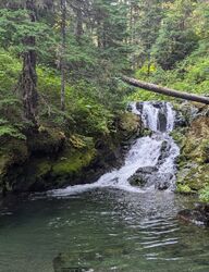
The approach is fairly flat, a bit brushy in places, and quite mild overall. Push through some unfriendly vegetation near the road for a short distance, then enjoy the pine needle and moss laden ground underneath the forest canopy. The remainder of the approach includes a marshy meadow and some bushwhacking through tall blueberry bushes before reaching the creek bed. The drop-in is just downstream of a small cascade with a deep pool. This is the reference photo. Compare flow before suiting up at the gravel beach here.
Descent[edit]
WARNING: This canyon is very committing.
- Waterflow is typically high - even in Aug/Sep.
- Team communication in Crack of Doom is very difficult.
- Beyond the the first
100 ft / 30mpitch, escape may not be possible. - Satellite communicators may have difficulty acquiring satellites due to the narrowness and sheer vertical walls.
Descent details[edit]
DCL = Down Canyon Left, DCR = Down Canyon Right
| Anchor | ||
|---|---|---|
| ||
| ||
| ||
| ||
| DCR - 1 bolt station | ||
Ahead, the canyon narrows into a deep crack about 20 ft / 7 m wide. You are approaching Crack of Doom.
| ||
Crack of Doom Pitch 1
| ||
Crack of Doom Pitch 2
Below Crack of Doom, the canyon widens and includes mostly small rappels and downclimbs. | ||
| DCR - boulder wrap | ||
| DCL - pinch | ||
| DCL - log | ||
Exit[edit]
Follow the creek downstream about 20 minutes until it bifurcates (splits). The left fork (DCL) leads to the bridge and parking area. The right fork goes to a separate drainage (Wells Creek), so take heed! Downstream of the split, a fairly clear path is available in the forest DCR all the way to the road.
Red tape[edit]
No permits or passes are required (the parking locations are not at a trailhead).
Beta sites[edit]
Waterfall websites:
Trip reports and media[edit]
- Group of 3 took us 5.5 hours car-to-car. The flow was slightly higher than in the “Very High” reference photo, yet the 3 big rappels all had relatively forgiving lines. We all agreed this was more like “High” flow. The first descent team probably spent considerable time equipping the canyon and were more fearful of the unknown. As it is now, we encountered 3 bolt stations, all in good condition, did 2 retrievable anchors and replaced 4 pieces of webbing. We brought a drill but did not see any reason it would be needed. Standard creeping and rope management skills seemed to make rope pulls and core shot a non-issue, or we just got lucky. What a stunning gorge! With walls hundreds of feet high and very close together. The three big rappels had our FULL ATTENTION. Kudos to the first descent to crew.
2025 run https://youtu.be/y2Qwd-gzBmU?si=k_snANeNI3nHwTYB
Background[edit]
Geology[edit]
The rocks in this section of Deadhorse Creek are of the Nooksack Formation. Based on the USGS geologic map, the upper section of the route is composed of argillite and sandstone (lithic-volcanic), and the Wells Creek Volcanic Member (dacite, andesite) begins at the Crack of Doom.
Geologic Map of the Mount Baker 30- by 60-Minute Quadrangle, Washington
First Descent[edit]
Deadhorse Creek was first descended on 2 September 2017 by Michelle Nilles, Jesse Houser, Dan Yeisley, and Tiffanie Lin. Luca Chiarabini had planned to be there, and in a multitude of ways, he was. Many thanks to Aaron Young and Bryan Swan for providing the waterfall photos and documentation for this spectacular set of falls.
Accommodations[edit]
Dispersed camping is available at several nearby locations, although the area is popular and campsites may be full on weekends and holidays in peak season.
There are a couple nearby national forest campgrounds:
- Silver Fir Campground
- Douglas Fir Campground
- Excelsior Group Camp appears to be closed indefinitely due to the November 2021 washout and was removed from the USFS website.
Lodging can also be found in Glacier.
Dining[edit]
Wake 'n Bakery in Glacier has great coffee and a hearty breakfast. North Fork Brewery in Deming is a local favorite for pizza, beer, and cider.
Cell Service[edit]
As of 2017, there is no cell service along Mount Baker Highway, so plan accordingly. Graham's Store in Glacier has WiFi, although it is limited/intermittent, and some devices have trouble connecting.
