References:Deadhorse Creek-20170906171425

From ropewiki.com
Jump to navigation Jump to search
  • Deadhorse Creek-20170906171425 pic.jpg
  • Location: Deadhorse Creek
    Reported by: Jesseahouser
    Date: 2 Sep 2017
    Comment: Taken from a point just upstream of the bridge where water flows over a log. This is not indicative of the actual flow in the canyon. The photo is presented as an initial datapoint to determine if correlation exists with true flow in the canyon.
    Waterflow: Very High
    Very Low Low Moderate-Low Moderate Moderate-High High Very High Extreme
    0% - 40% 40% - 70% 70% - 90% 90% - 110% 110% - 130% 130% - 160% 160% - 200% >200%

    • Very Low: Water flow should not represent any danger (class B = a2).
    • Low: Not as fun, but should be safe even for beginners (class B/C = a3).
    • Moderate-Low: A bit low, still fun but not very challenging (class C1- = a4-).
    • Moderate: Challenging but not dangerous for intermediate canyoneers (class C1 = a4).
    • Moderate-High: A bit high, quite challenging but not too dangerous (class C1+ = a4+).
    • High: High water, only for experienced swift water canyoneers (class C2 = a5).
    • Very High: Dangerously high water, only for expert swift water canyoneers (class C3 = a6).
    • Extreme: Extremely dangerous high water, may be unsafe even for experts (class C4 = a7).

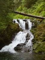
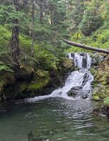
    Historical reference pictures used in Waterflow analysis[edit]


    (log in to submit reference picture)

    5 Sep 2020
    High
    7 Sep 2024
    High
    2 Sep 2017
    Very High
    2 Sep 2017
    Very High
    Deadhorse Creek-20200907212650 pic.jpg Deadhorse Creek-20240909194428 pic.jpg Deadhorse Creek-20170905221818 pic.jpg Deadhorse Creek-20170906171425 pic.jpg