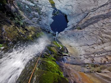
Deadman Canyon (Pinaleno Mountains)
| Rating: | |||||||||||||||||||||||||||||||
|---|---|---|---|---|---|---|---|---|---|---|---|---|---|---|---|---|---|---|---|---|---|---|---|---|---|---|---|---|---|---|---|
| | Raps:2-3, max ↨220ft
Red Tape:No permit required Shuttle:None Vehicle:4WD - High Clearance Rock type:Granite | ||||||||||||||||||||||||||||||
| Location: | |||||||||||||||||||||||||||||||
| Condition Reports: | 12 May 2023
"The first rappel was spectacular at this flow and canyon overall was better than anticipated. Plenty of brush and poison ivy throughout the watercours |
||||||||||||||||||||||||||||||
| Best season: | spring or fall, BEST in spring
|
||||||||||||||||||||||||||||||
| Regions: | |||||||||||||||||||||||||||||||
Introduction[edit]
Though the two waterfall rappels that define Deadman Canyon are fun and scenic, there is not much else to the canyon besides them.
Although forgiving by Arizona standards, the canyon is fairly chocked with brush. Large patches of poison ivy are also present. Pants and long sleeves advised.
Approach[edit]
From Phoenix, drive east on the US60 through the city of Globe, then take US70 towards Safford. Just after reaching the small city of Thatcher, turn right (south) on Reay Lane (turns into Hoopes Ave near the golf course) between mile posts 335 and 336. After 3.4 miles turn right onto Brinkerhoff St which quickly becomes Frye Creek Rd and bends to the south. Turn right where the road turns to dirt to stay on Frye Creek Rd (also apparently FR 650, we didn't see any signs) and follow this bumpy, rocky, slow road south, then southwest for about 3.5 miles.
There is only one intersection of note along the way - shortly after a large water tank on your right will be a T or Y in the road, take the right branching road to stay on course. At the 3.5 mile mark is a junction with FR 6629 which continues up a rocky ridge towards Deadman Mesa.
Either park at the intersection and hike the remaining 1.4 miles up FR 6629 or drive the road to the trailhead - depending on your vehicle. The road isn't much worse for this stretch (at least when we were there - conditions might change frequently here), but it was certainly steeper. Two small, rickety old posts mark the beginning of the trail on the right once you reach the top of Deadman Mesa.
Walk through the posts to locate the beginning of Deadman Trail. The area suffered significant burn damage in the Frye Creek fire of June 2017 making the trail quite difficult to see, though very frequent cairns make the way easy to follow. Follow the rock cairns for about 2.5 miles until the path begins to descend towards the bottom of Deadman Canyon and head down to the canyon floor as soon as you see an easy way to do so.
Descent[edit]
Hike down canyon through the brush and along the slickrock to arrive in short order at the first rappel.
R1: 220' off single bolt and hanger on canyon right fairly close to the edge.
- From the anchor to the pool below is about 160 feet; at the far end of the pool is another drop of about 40 feet.
- A 220-foot rope will just barely make it to the bottom of this second drop. An extra 20-30' of rope (or webbing) may be needed to retrieve your rope from the bottom.
- It is also possible (perhaps advised) to pull the ropes from the first stage and downclimb around the final drop on canyon left.
This first rappel is a memorable one - a beautiful winding fall with a long polished chute for a fast and fun hip-slide. Beyond this vertical sequence is a half a mile of mostly uneventful creek hiking and brush thrashing (along with some downclimbs and small slides) before you reach the second rappel.
R2: 70' off rock chock canyon right, or 60' off a boulder nearer to the lip.
- This second scenic falls drops about 20 feet to a platform then another 30 feet to the canyon floor, giving you a nice shower on the way down as the falls pour off a large chock stone rock above you.
- Potential for rope retrieval issues depending on flow level (cracks in the watercourse).
After the second drop is another stretch of bushwhacking and rock hopping, this time about .7 miles before you reach the exit trail.
Exit[edit]
A minor trail can be found on canyon left right around where "Gaging Station" is written on the topo maps - you will also see a large corrugated metal pipe in the canyon where the trail starts. The trail is fairly easy to follow, and will take you back up to the road and trailhead at the top of Deadman Mesa; passing through (and closing behind you!) one wire gate along the way.
