Deadwood Gulch
| Rating: | |||||||||||||||||||||||||||||||
|---|---|---|---|---|---|---|---|---|---|---|---|---|---|---|---|---|---|---|---|---|---|---|---|---|---|---|---|---|---|---|---|
| | Raps:7, max ↨125ft
Red Tape:No permit required Shuttle:Required 7 min Vehicle:Passenger Rock type:Gneiss, Schist | ||||||||||||||||||||||||||||||
| Start: | |||||||||||||||||||||||||||||||
| Parking: | |||||||||||||||||||||||||||||||
| Shuttle: | |||||||||||||||||||||||||||||||
| Condition Reports: | 15 Aug 2022
"All rock in the watercourse was incredibly slippery which slowed our movement considerably and made for a few challenging downclimbs. 4/3 wetsuit w/ j |
||||||||||||||||||||||||||||||
| Best season: | Jul-Sep
|
||||||||||||||||||||||||||||||
| Regions: | |||||||||||||||||||||||||||||||
Introduction[edit]
A fun, short canyon just outside the town of Silverton. The technical route described here drops 600 feet in elevation in about a half mile. Minimal approach and exit distances with a 10 minute shuttle. Great to combine with the Durango Waterpark (Lower Cascade Creek (Durango)), South Fork Mineral Creek, Cataract Creek or another short canyon in the Silverton area for a two-in-one day.
Note that the rock in this canyon is extremely slippery and downclimbing through the watercourse can therefore be quite challenging (warrants R rating). Some anchors are also situated high above the watercourse and require some exposed scrambling to reach.
This waterfall is a confirmed nesting site for the Black Swift, listed as a Species of Special Concern by the U.S. Forest Service and U.S. Fish and Wildlife Service. The swifts migrate from Brazil annually to occupy this site from late May until late September, raising a single chick. The swifts are susceptible to disturbance from human activities near their nests, including noise and movement, direct disturbance or destruction of their nests, and trampling of vegetation. Canyoneering/climbing at this waterfall during the Black Swift nesting season (late May - late September/first frost) is likely to cause direct damage to nests, eggs, and young, and disturb adult swifts enough to cause them to abandon their nest and offspring. Click here for more information on the Black Swift.
Approach[edit]
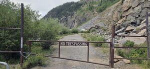
Leave a Shuttle vehicle at (37.79177, -107.66905). A gate was installed next to this parking location clearly indicating No Trespassing near the old mine.
From the gas station on Highway 550 in Silverton, go south on 550 for 0.1 miles. Just after passing over the bridge crossing Mineral Creek, turn left on a dirt road, County Road 31. Go down CR31 for 1.0 miles to a large dirt parking area.
Drive back to Hwy 550 and turn left toward Durango, leaving Silverton to the West.
Park the top vehicle at a pull off West of Hwy 550 next to the watercourse (37.78466, -107.67297).
Hike downstream through the metal culvert under the road or cross the road and hike down the slope.
Descent[edit]
Be sure to put on gloves and helmet before you begin your descent. This is a good practice in any canyon, but especially in Deadwood Gulch as there are many sharp rocks strewn along the ground and under the undergrowth that are not easily seen, and as mentioned above the rock is very slippery. After exiting the culvert, pick your way down the side of the watercourse.
Just below the high powerlines you will come to the first rappels in quick sequence:
R1: 35' off a tree on Canyon Right.
R2: 50’ off a tree high Canyon Right. Unfortunately, this rappel line misses the watercourse. Be on the lookout for R3 high canyon left - it is easy to miss and continuing to the lower stage may limit anchor opportunities.
R3: 70' off a tree high Canyon Left.
R4: 50’ off a tree high Canyon Left.
R5: 80’ off a tree high Canyon Right. This fall line is out of the flow and lands just above the old remnants of Detroit Mine. You will notice an open mine shaft on canyon right and significant mine debris blocking the watercourse. CAUTION! This debris has numerous rusty nails sticking up and contains rusty sheet metal with sharp edges. Stay well clear of this waste pile by going carefully around high canyon right and onto a ledge (ledge is approximately level with the mine shaft).
R6: 65' off a tree anchor about 50 feet down along this ledge. Before rappelling you may want to continue all the way across the ledge for a commanding view of the Animas River, the Durango-Silverton railroad tracks, with the town of Silverton as the backdrop. If you are lucky you may hear the train whistle and see the old, narrow gauge train rolling down the tracks from your high perch.
R7: 125' off tree on Canyon Right. Alternatively, an anchor could be set off a tree canyon left which may better position you in the flow but requires crossing the debris-riddled watercourse.
Exit[edit]
Find a social trail canyon left at the base of the last rap. Walk this trail until the Durango and Silverton Narrow Gauge Railroad bridge over the Animas River comes into view and depart the trail toward the river. Do not walk the 4WD road which leads back to the mine.
Hike along the river on social trails toward the train tracks, which is signed No Trespassing over the bridge. Follow the tracks over land to the North back toward the bottom parked vehicle, avoiding the private land. Duck back through the vegetation on a social trail to the parking area.
Red tape[edit]
Beta sites[edit]
Trip reports and media[edit]
First (Published) Descent 8/8/15 Kelton Manzanares, Logan DeGrand, and Mike Zampino. Old anchors and evidence of anchors were found at the last few rappels.
Background[edit]
Be considerate and leave solid anchors throughout this canyon as this has been climbed in winter. This is not a location for releasable anchors to keep harmony between those who participate other seasonal activities in the same space.


