Eastern Sun
| Rating: | |||||||||||||||||||||||||||||||
|---|---|---|---|---|---|---|---|---|---|---|---|---|---|---|---|---|---|---|---|---|---|---|---|---|---|---|---|---|---|---|---|
| | Difficulty:3A III (v3a1 III) Raps:7, max ↨165ft
Red Tape:No permit required Shuttle:Required 45 min Vehicle:4WD - High Clearance | ||||||||||||||||||||||||||||||
| Location: | |||||||||||||||||||||||||||||||
| Condition Reports: | 19 Oct 2023
"Descended Eastern Sun then up Virgin River and set up tent at bottom of Mighty Mouse and ran through that in evening. Next morning did Deadeye Dick. B |
||||||||||||||||||||||||||||||
| Best season: | May-Oct
|
||||||||||||||||||||||||||||||
| Regions: | |||||||||||||||||||||||||||||||
Introduction[edit]
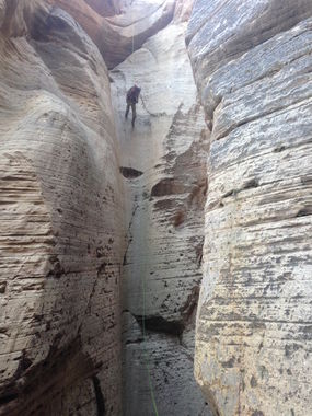
One of the few dry canyons in the Zion area. The deep, narrow gash in the desert floor appears out of nowhere, akin to Englestead, making for a breathtaking view at the first rappel station. One rappel after another, reminiscent of Birch Hollow. If you are on the east side of the park, a good option if you have done all of the 5-star and 4-star canyons. Nothing special here. Canyoneering USA recommends a fiddlestick.
Approach[edit]
4 miles cross-country, 2 hours 10 minutes at a brisk pace
Descent[edit]
R1: Rock Pinch, canyon right, 165 feet, down a dry flute
R2: Rock Pinch, mid-canyon, 40 foot rappel
R3: Rock Pinch, canyon left, 38 foot rappel
R4: Log, mid-canyon, 30 foot rappel
R5: Canyon right, downclimb 20 feet top stage, get on rappel, 20 foot rappel
Then three 20 foot downclimbs. Last one has rock pinch anchor for handline. Dry flute offers plenty of friction.
R6: Deadman, mid-canyon, 20 foot rappel
R7: Deadman, mid-canyon, 45 foot total, 2-stage, top stage over wet pothole can be bridged over. No need to keep feet dry as the hike up the North Fork is right around the bend and your feet will be wet for the next 2 1/2 hours.
Exit[edit]
Hike 6 miles up North Fork. Past abandoned hunter's cabin. Through double metal gate. To farmer's pump house on right. Or continue 1/2 mile to drop-off for Narrows Through Hike and bathroom there.
Red tape[edit]
Permit is required as the lower end crosses into the National Park boundary.
Beta sites[edit]
 Zion Canyoneering Book by Tom Jones : Eastern Sun
 BluuGnome.com : Eastern Sun Canyon
 CanyoneeringUSA.com : Eastern Sun Canyon
 Super Amazing Map : Eastern Sun
Trip reports and media[edit]
8/19/15, 7 hours + 2 hours waiting for shuttle and drive out
Background[edit]
First descent made by Kip Marshall, Bruce Snow, Gaydon Leavitt and Tom Jones on 7/29/12
