Empress Canyon
| Rating: | |||||||||||||||||||||||||||||||
|---|---|---|---|---|---|---|---|---|---|---|---|---|---|---|---|---|---|---|---|---|---|---|---|---|---|---|---|---|---|---|---|
|
| |||||||||||||||||||||||||||||||
| | Difficulty:3B I (v3a2 II) Raps:1, max ↨92ft
Red Tape:No permit required Shuttle:None Vehicle:Passenger Rock type:Sandstone | ||||||||||||||||||||||||||||||
| Start: | |||||||||||||||||||||||||||||||
| Parking: | |||||||||||||||||||||||||||||||
| Condition Reports: | |||||||||||||||||||||||||||||||
| Best season: | Sep-May
|
||||||||||||||||||||||||||||||
| Regions: | |||||||||||||||||||||||||||||||

Introduction
Empress canyon is an easy beginners canyon situated in the beautiful Jameson valley. It is a spectaular slot canyon with some optional jumps, down climbs, a slide and a 30m abseil. Between 12 and 2 in spring and summer, the canyon is very crowded and you can wait up to an hour to rappel. You should probably wear a wetsuit as the water is quite cold year round.
Approach
Driving: Use GPS app of choice to drive to [Conservation Hut car park].
Walking: From the conservation hut follow the National Pass Track until you reach a T- junction at the bottom of a set of steep metal stairs, turn right taking the nature track. You will cross a bridge, this will be your first look into the canyon, continue onwards until you reach the stepping stones across Valley of the Waters Creek. The stepping stones mark the start of the canyon, there is a log book in a freestanding metal stand which you can fill in. There are numerous commercial operations that use this canyon, completing an entry in the logbook will help groups avoid traffic jams at the abseil.
Descent
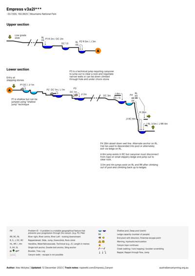
The canyon immediately narrows, there are some tricky down climbs, short swims, some optional jumps and a 3-4m slide. The slide will take you to the top of the rappels. There are conspicuously oversized linked chainsets and access bolts on both river left and right installed by NPWS.
The river left anchor is typically easier as it does not go straight through the waterfall, dropping 15m to a ledge from which you can jump or 28m to a pool at the bottom. The right hand side goes down 28m to the bottom pool.
Topo
Exit
There is an obvious track at the bottom that leads back to a junction with the descent track, turn right here and follow the signs back up to Conservation Hut carpark.
Red tape
Beta sites
- http://ozultimate.com/canyoning/track_notes/empress.htm
- http://www.immortaloutdoors.com/articles/empress_canyon
- http://www.alternatezone.com/canyoning/empress.htm
- http://www.nationalparks.nsw.gov.au/things-to-do/guided-tours/abseiling-and-empress-falls-canyon
 Descente-Canyon.com : Empress
 CanyonMag.net : Empress Canyon
Trip reports and media
 Wikiloc.com : Empress Canyon