Falls Creek (San Jacinto Mountains)
| Rating: | ||||||||||||
|---|---|---|---|---|---|---|---|---|---|---|---|---|
| | Difficulty:4B IV (v4a2 IV) Raps:5-11, max ↨180ft
Red Tape:No permit required Shuttle: Vehicle:Passenger | |||||||||||
| Location: | ||||||||||||
| Condition Reports: | 14 Feb 2021
"Walked along the paved PCT at first and then cut over to the gully. The climb up the gully, while steep, wasnt too bad. After that, most vegetation h |
|||||||||||
| Best season: | ||||||||||||
| Regions: | ||||||||||||
Introduction[edit]
This is a fabled forbidden canyon with a long history of access problems. The lower section of the canyon lies within DWA private property (purple zone in the map) and therefore is forbidden. However, the upper section of the canyon lies outside of the DWA domain and can be accessed without breaking the law.
The water is very cold, so waterproof jacket and pants and thick gloves are recommended. Wetsuits are not required since all swimming pools can be easily avoided. Best time will be Spring and Fall. The hike up would be brutal in summer. Days may be too short in Winter. This canyon is NOT FOR BEGINNERS. The approach and return routes are strenuous and require strong navigational skills. If you attempt this adventure you should probably have an early start but be prepared to exit in the dark.
This canyon may flow strong in spring after a big snow winter, so make sure you check the waterflow before attempting a descent. Falls Creek is gauged, so you will know EXACTLY how much water is flowing.
Approach[edit]
The upper section of the technical canyon starts near the isthmus of Fall and Snow Creek. Other beta recommends a mountaineering approach to access this area, we include it in the map but advise against using it. Section 28, which is open to hiking, offers a ravine that provides a more direct access to the crest. The base of the ravine can be accessed by paved road or by a sandy wash. I recommend to walk the wash for the approach because it is shorter and more direct but to take the paved road for the exit because it goes by a water fountain and a paved road will be easier to walk on after dark. However, feel free to change the options to fit your timeframe and preferences.
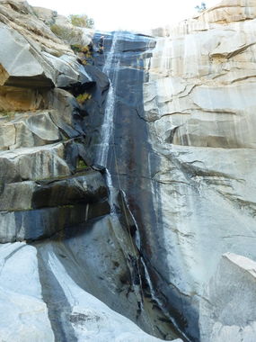
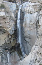
The climb up the ravine is steep, but is without exposure and fairly easy. Once you reach the first Vista Point you may see cairns marking the way up to the crest. From the Vista Points you will have a fantastic view of the 400' monster waterfall, which sadly lies within the forbidden zone.
Once at the top of the crest the progression is mostly flat traversing across boulders and brush all the way to the isthmus. In the vicinity of the drop in point you may choose to do the extension, which will add 6 rappels and a few more hours to your journey.
Descent[edit]
Upper Extension:
- R1: two step, 150', bush high DCL (can be downclimbed)
- R2-R5: undocumented, but all can be downclimbed
- R6: 60' to a shallow pool (possible to downclimb)
Upper Section:
- R1: 30' from a tree with fiddlestick (no webbing left behind as hiker may access this area); possible to downclimb
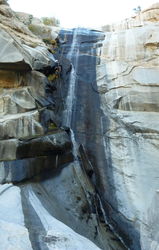
- R2: 180' from a tree DCR at the edge of the waterfall (title photo)
- R3: 80' from a tree DCL to a shallow pool, possible to get splashed
- R4: 80' from a tree DCR to a waist deep pool that may be partially averted on DCR
- R5: 160' from tree DCR, inclined slope with a short vertical end, careful with the pulldown; can be downclimbed
Lower Section: (this section is in the forbidden zone, please respect the closure)
- R1: 60' into very cold pool. Supposed to be a bolt cyn right but hard to find. rap is easily down-climbable on canyon right and it avoids a COLD mandatory swim. *
- R2: 400' can be done as 2-pitch, 180/220. Bolts are very exposed and belay is needed to get to them, canyon left of center. 2nd pitch is at a small alcove, not really good footing so its a semi-hanging rebelay. it is right below the upper bolt station, if you stay on a straight line from the top you cant miss them. One good bolt and one likely very rusted piton.
- R3: 120' bolts canyon left, into a pool that I think is a short swimmer.
- R4: 215' single bolt canyon left for the first 65', down a narrow chute to a ledge with 2 bolts for the remaining 150'.
- R5: 65' off 2 bolts canyon right, at the edge.
- R6: 200' 2 pitch, 65' off single bolt to small ledge with 2 bolts for the remaining 125-130'.
Bing Maps has very high resolution Bird View aerial pictures of the area that allows to properly identify some of the waterfalls. You can see the Bing Map of the route at http://www.bing.com/maps/?mapurl=http://ropewiki.com/images/3/3c/Falls_Creek_%28Snow_Creek%29.kml
Exit[edit]
The currently documented exit is hard, it requires class 4 exposed climbing that some may not be comfortable with. From aerial pictures there seems to be a better spot further downstream that may prove to be a much easier exit. The "easy exit" was explored on 14 February 2021 and turned out to be reasonably easy, taking 0:40.
Red tape[edit]
The DWA has a full time custodian living on the premises, guard dogs, surveillance cameras, etc. If you are caught in this area you may be cited and/or arrested for trespassing. They used to crack down on people accessing section 28 too, but after a confrontation with local Snow Creek Village residents it was clarified that DWA can only prosecute trespassers of section 33. More information at http://www.americancanyoneers.org/socal/mt-san-jacinto-access/. Full story at http://www.summitpost.org/phpBB3/desert-water-agency-dwa-property-t57995.html
Apparently DWA used to give permission to access section 33 to Search&Rescue groups and even private individuals that requested a permit, but sadly that practice was discontinued. Please respect the closure and stay clear of section 33. If you want to try to request a permit contact DWA management at http://www.dwa.org/Management-and-Departments
Beta sites[edit]
- http://www.mtsanjacinto.info/viewtopic.php?t=708
 SummitPost.org :
- http://www.traditionalmountaineering.org/Photos_SnowCreekRoute_sm.htm
- http://socalhikes.com/2010/08/snow-creek-to-san-jacinto/
- http://christianlupercio.com/blog/2013/11/5/snow-creek-attempt
Trip reports and media[edit]
Background[edit]
Sonny Lawrence and Luca Chiarabini did what may well be a first descent of Upper Falls Creek on 16 Nov 2014 aided by information provided by Christian Lupercio, Dave Red and Scott Swaney. We never saw any other anchors, built new ones at every drop. We ascended through a previously undocumented route up a ravine from section 28 and returned through the mountaineering route because Sonny wanted to see how it compared (horrible!). The Upper Extension was descended in February 2021.


