Fish Creek (Swallowtail)
| Rating: | |||||||||||||||||||||||||||||||
|---|---|---|---|---|---|---|---|---|---|---|---|---|---|---|---|---|---|---|---|---|---|---|---|---|---|---|---|---|---|---|---|
| | Raps:7, max ↨270ft
Red Tape:No permit required Shuttle:None Vehicle:Passenger | ||||||||||||||||||||||||||||||
| Start: | |||||||||||||||||||||||||||||||
| Parking: | |||||||||||||||||||||||||||||||
| Condition Reports: | 22 Jul 2023
"With 95F on the NOAA forecast, the air and water was warm enough to be pleasant without raincoats. The first-descent related routefinding added at lea |
||||||||||||||||||||||||||||||
| Best season: | May - Sep
|
||||||||||||||||||||||||||||||
| Regions: | |||||||||||||||||||||||||||||||
Introduction[edit]
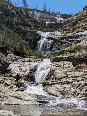
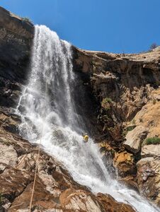
Swallowtail is a great way to enjoy some splashy early-season fun. Its rappels are long, particularly slippery, and full of fun surprises. Unlike its neighboring canyons, these rappels tend to have diffuse flow and no significant entrapment hazards, making it an acceptable canyon for beginners with experienced guidance.
In return for your enjoyment on the way down, you will pay handsomely on the exit, which is an unrelenting bushwhack straight up the side of the San Joaquin gorge.
Approach[edit]
From Minarets road parking, hike west along the ridgeline until you see the first drop, then descend into the drainage.
Descent[edit]
R1: 270’ off a bolt DCL near the lip. No good way to break into 200’ sections, but bypassable DCL.
R2: 90'(?) off a boulder pinch DCL
R3: 110’ off a boulder pinch DCR near the lip
R4: 200’ off a boulder DCR. Watch out for a rope-eating rock at the bottom of the falls on the pull
R5: 70’ off a flake DCR
R6: 160’ off a boulder pile that may wash away DCL near the lip. Anchoring DCR would keep you more in the flow
R7: 30’ from a chockstone just left of the drainage near the lip
Exit[edit]
Continue down canyon until you’re about 300’ from the San Joaquin, then look DCL for the megacairn indicating the exit route. This would be a great time to dry out your gear to dry and wait for the sun to dip below the horizon. When you’re ready, hike up the DCL ridge, eventually intersecting with the approach trail and retracing your steps to the car.
This exit hike kinda sucks. The brush isn’t as bad as it could be (unless more grows in as the area recovers from the Creek fire), and the poison oak is pretty avoidable, but it’s still a hot 2300’ of elevation gain up a loose 70% slope.
Red tape[edit]
Minarets road is sometimes closed for repairs without updating Caltrans or Google Maps. Before leaving, consult the USFS and look for a map of closures under alerts and warnings.
Beta sites[edit]
Trip reports and media[edit]
Background[edit]
First descent by Epeairs, Sqshemet, and Feroz.
Named after the lovely pale swallowtails seen in the area, and because there's way too many Fish Creeks. Like, there's even another Fish Creek just up the San Joaquin.

