Fortress
| Rating: | |||||||||||||||||||||||||||||||
|---|---|---|---|---|---|---|---|---|---|---|---|---|---|---|---|---|---|---|---|---|---|---|---|---|---|---|---|---|---|---|---|
| | Difficulty:3B III (v2a2 II) Raps:1-3, max ↨26ft
Red Tape:No permit required Shuttle:None Vehicle:Passenger Rock type:Sandstone | ||||||||||||||||||||||||||||||
| Start: | |||||||||||||||||||||||||||||||
| Parking: | |||||||||||||||||||||||||||||||
| Condition Reports: | |||||||||||||||||||||||||||||||
| Best season: | Dec - Mar
|
||||||||||||||||||||||||||||||
| Regions: | |||||||||||||||||||||||||||||||
Introduction[edit]
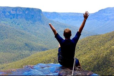
Fortress canyon is famous for the view at the end, which is the top of a 70m waterfall (which you do not descend) looking out over the Grose Valley. It is an easy canyon ideal for beginner groups or those looking for a short trip. A wetsuit is recommended.
Approach[edit]
Fortress Ridge Car Park (Google Maps link) at Corner of Mt Hay Road and Fortress Ridge trail. MGA556726
Download the GPX.
- Superior/Upper entrance (-33.63854, 150.36235)
- Inferior/Lower entrance (-33.63660, 150.35567)
Superior/Upper entrance[edit]
The Superior/Upper entrance is the classic entrance of Fortress is at -33.63854, 150.36235. This has historically been the most common entry for the canyon. It places you almost 1km upstream of the best part of the canyon. The ~1km to the start of the Inferior/Lower entry is mainly creek walking and the odd dip. This creek walk can be skipped by entering at the Inferior/Lower entry.
Inferior/Lower entrance[edit]
The Inferior/Lower entrance of Fortress enters the canyon very close to the 2m jump and start of the best bit of canyon. The Inferior entrance requires diverting from the entrance track at -33.64307, 150.35849 and heading off track North West along the ridge towards -33.63660, 150.35567. A side creek/gully enters Fortress canyon here.
At the top of the corner bluff at -33.63660, 150.35567 head upstream on the river right of the side creek/gully for a little bit (no more than 50m) to scramble the cliff edge and enter the side gully.
Proceeding down the side creek you will reach a small waterfall/8m abseil. Descend waterfall using anchor on river right to enter Fortress.
Descent[edit]
Superior/Upper section[edit]
Walk alongside the creek, or walk in it where you need to, occasionally climbing over branches, logs and rocks. The first, short section of canyon starts with a short down climb that can also be jumped, followed immediately by a 20m swim. The canyon opens up again following this and is predominately a creek walk with the odd wade or dip.
Inferior/Lower section[edit]
The lower section of canyon starts with a scramble down a large boulder that takes you to a 2m water jump. First person should check depth.
After some more scrambling and wading you come to the third and most impressive canyon constriction. It starts with a 6m abseil from a bolt on the left hand side of the canyon. This can also be jumped, but the water is not particularly deep (usually less than 2m) and there are rocks that need to be avoided.
After some more swimming and scrambling the canyon comes to an end. Continue along the creek for about 100m to the very end, where it plunges over an impressive waterfall. This is a spectacular spot for lunch.
Exit[edit]
The canyon ends at the top of a 70m waterfall known as Fortress Creek Falls, MGA427752 | -33.63413, 150.35075 with great views. To exit go back upstream 50m and exit on to easy track to the west, keep left at the top cliff line to access the Fortress Ridge Track and follow that back to car. There are some spectacular views available from the track, or with a quick detour onto The Fortress.
Red tape[edit]
Beta sites[edit]
https://ozultimate.com/canyoning/track_notes/fortress.htm
Trip reports and media[edit]
https://sleepwhenwearedead.net/2016/01/10/empress-and-fortress-canyons-10-01-16/
