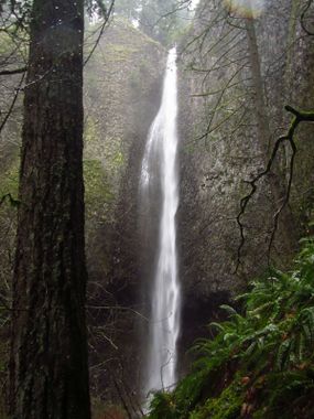
Gable Creek
| Rating: | |||||||||||||||||||||||||||||||
|---|---|---|---|---|---|---|---|---|---|---|---|---|---|---|---|---|---|---|---|---|---|---|---|---|---|---|---|---|---|---|---|
| | Raps:2-3, max ↨240ft
Red Tape:No permit required Shuttle:None Vehicle:Passenger | ||||||||||||||||||||||||||||||
| Start: | |||||||||||||||||||||||||||||||
| Parking: | |||||||||||||||||||||||||||||||
| Condition Reports: | 17 Jan 2026
"Only ran the big drop, rest of the creek with wind storm and high water was a complete mess of crap. Need a chainsaw and machete. Flow was not as high |
||||||||||||||||||||||||||||||
| Best season: | July-Sep (avg for this region)
|
||||||||||||||||||||||||||||||
| Regions: | |||||||||||||||||||||||||||||||
Introduction[edit]
A little-known creek close-in to Portland. The creek has two nice waterfalls (one of them being over 200ft high), but they're a fair distance apart. Expect to spend most of your time creek-walking and bushwhacking -- sometimes both at once for long stretches -- making this one a somewhat high pay-to-play. The big falls can be run by itself relatively easily, although hiking in for a single waterfall may not be worth your time.
- Watershed: 0.3mi^2.
- The checkpoint for Gable is along the road you drive in on to the trailhead.
Approach[edit]
Park at the end of the county road. Walk up past a gate into High Valley (former hippie commune in the 1980's; land is now owned by the DNR). Turn left immediately on a trail and follow it up onto the ridge. Keep going up. At about 900ft elevation, bear left on an old logging grade and drop down to the creek above the upper falls.
- There are a great many informal, unsigned trails in the Gable Creek drainage. It's easy to become lost. Bring a map & GPS-capable device.
Descent[edit]
Gable Creek reduces to a trickle in the summer months, and, as a result, it's completely overgrown in some areas. Expect serious bushwhacking... sometimes bushwhacking while wading in the creek (aka "splash-whacking"). A machete might be useful.
- R1: 40'. Check out the neat cave-like space below the falls. It's bigger than it looks.
- 35ft drop choked with vegetation. Bypass DCL or, if in need of punishment, rappel.
There used to be an old trail DCL above the creek, but there's not much left of it. As of 2022, it was faint and hard to follow. Thrash, bushwhack, scrabble, wade, and squelch your way downstream.
- R2: Gable Falls ~210ft from a small tree DCL just above the brink.
- High water: ~240ft from a tree high DCR. Rappel over a knob about 10ft above the brink. This acts as a natural redirect to keep you out of the main flow. Take precautions to protect your rope as the top of the falls has sharp edges and lots of loose rock. Anyone present at the base of the falls may risk getting struck by rockfall.
There is one more 10ft drop immediately downstream, but it's not worth your time. Most parties will exit via the trail after R2.
Exit[edit]
After the last rappel, follow the trail back to the ridge. Do not keep going down the creek or you'll end out in someone's backyard.
Red tape[edit]
Gable Creek lies inside the Columbia Falls Natural Area Preserve (NAP) which is managed by the Washington State Department of Natural Resources (DNR). In theory, NAP areas are as close to wilderness as it gets. Historically, however, this area has been open to access, and has an extensive trail network. (These trails are even featured in one hiking guidebook to the Columbia Gorge.) There are no official signs or information about land management posted at this site. Both sides of Gable Creek were logged back in the day, and people have been hiking in this area as far back as the 1930's. The trailhead for Gable is actually on National Forest land and was the site of a hippy commune in the 1980's. The lower valley was an orchard and today has a serious problem with invasive blackberry.
- Hikers and waterfall photographers visit this area far more than canyoneers.
- For more information, see Columbia Falls Natural Area Preserve. The webpage mentions basalt cliffs and steep talus slopes. This appears to be a reference to Archer Valley, the next drainage east of Gable, which is home to several endangered plant and animal species. According to the website, the valley is closed to visitors.
Beta sites[edit]
 CanyoneeringNorthwest.com (archive.org) : Gable Creek
 Super Amazing Map : Gable Creek
Trip reports and media[edit]
https://m.youtube.com/watch?v=UbnXmUXWGBo&t=4s
Background[edit]
Gable was probably first descended by Evan Topinka in Sept 2008.
